Copper Lake Borehole EM Surveys Yield Strong Conductors Situated at Depth, on the Marshall Lake Copper-Zinc-Silver-Gold VMS Property, Northern Ontario
TORONTO, May 31, 2022 (GLOBE NEWSWIRE) -- Copper Lake Resources Ltd. (TSX-V: CPL, Frankfurt: WOI, OTC: WTCFZ) (“Copper Lake” or the “Company”) is pleased to announce that is has obtained very encouraging results generated from recently completed borehole electromagnetic (BHEM) surveys, on its Marshall Lake copper-zinc-silver-gold volcanogenic massive sulphide (VMS) property (the “Property”), located northeast of Thunder Bay, Ontario. The BHEM surveys were undertaken on three strategically located drill holes, to assist in vectoring towards thicker accumulations of sulphide mineralization at the site of a new high-grade VMS discovery, known as the VTEM/Deep IP discovery (see Copper Lake news releases dated May 10, 2022 & April 19, 2022).
Borehole Electromagnetic Survey Results
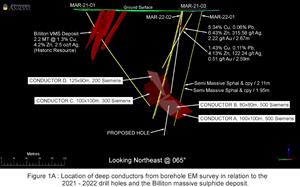
All of drill holes Mar-21-01, Mar-21-03 and Mar-22-02 detected strong conductors near the ends of the holes. Modelling suggests that all responses are likely due to a single strongly conductive source, with collective dimensions of at least 250 metres by 150 metres (see Figure 1A). The four strong conductors detected by the survey are situated at depth, 250 metres or more below surface. Hole Mar-22-01 was no longer accessible for surveying.
Specifically, conductors A and B are well-defined very strong conductors situated 325 metres below surface. Additionally, conductors C and D are also strong conductors detected in holes Mar-21-01 & Mar-21-03. The fact that all three of the drill holes picked up the same strong conductive response at depth, suggests that the conductor may be of greater size than what was modelled from the BHEM surveys.
The presence of such strong conductors at depths of greater than 300 metres below surface is very encouraging, as it confirms the potential for discovering much greater thicknesses of high-grade VMS mineralization at depth.
Additional diamond drilling is clearly warranted to test these strong conductors and the priority hole will test the heart of the conductive source including conductors A and B, as illustrated on Figure 1A.
Summer Exploration Program Plans
Given the presence of strong conductors at depth, situated within the confines of the broader conductivity and chargeability anomalies defined by the deep IP/magnetotelluric survey, strong consideration is being given to completing a ground large-loop pulse electromagnetic (PEM) survey covering the entirety of the large IP anomaly. Large loop electromagnetics will provide EM data to depths greater than previous surveys (>300 metres) and will help to define specific drill targets within the broader IP anomaly (Figures 1B & 1C).
The first priority for diamond drilling this summer, will be to test the strong conductors situated at depth below the new VTEM/Deep IP discovery, in an effort to further delineate this new zone of VMS mineralization.
The second priority will be an initial drill test of the Deeds Island VMS target. A prominent residual gravity anomaly (200 metres by 100 metres) at this site is closely associated with a strong zinc geochemical anomaly, a zone of strong hydrothermal alteration and a number of airborne EM conductors. The gravity anomaly is currently being modelled in 3D, to help define specific high-priority drill targets. The Deeds Island target, located 6 km to the east of the Billiton deposit is an attractive VMS target that has never been previously tested by diamond drilling.
QUALIFIED PERSON
Donald Hoy, M. Sc., P. Geo., Copper Lake’s Vice President of Exploration, is the Qualified Person responsible for the technical content contained in this news release.
ABOUT COPPER LAKE RESOURCES
Copper Lake Resources Ltd. is a publicly traded Canadian mineral exploration and development company with interests in two projects both located in Ontario. www.copperlakeresources.com
The Marshall Lake high-grade VMS copper, zinc, silver and gold project, comprises an area of approximately 220 square km located 120 km north of Geraldton, Ontario and is accessible by all-season road from the Trans-Canada Highway and just 22 km north of the main CNR rail line. Copper Lake has a 75% interest in the joint ventured property, which consists of 233 claims and 52 mining leases. The project also includes 148 claim cells staked in 2018 and 2020 that are 100% owned and not subject to any royalties, which add approximately 30 square km to the original property.
In addition to the original Marshall Lake property above, Marshall Lake also includes the Sollas Lake and Summit Lake properties, which are 100% owned by the Company and are not subject to any royalties. The Sollas Lake property consists of 20 claim cells comprising an area of 4 square km on the east side of the Marshall Lake property where historical EM airborne geophysical surveys have outlined strong conductors on the property hosted within the same favorable felsic volcanic units. The Summit Lake property currently consists of 100 claim cells comprising an area of 20.5 square km, is accessible year-round, and is located immediately west of the original Marshall Lake property. The Marshall Lake project is located in the traditional territories of the Aroland and Animbiigoo Zaagi igan Anishinaabek (“AZA”) First Nations.
Copper Lake also has a 71.41% joint venture interest in the Norton Lake nickel, copper, cobalt, and palladium PGM property, located in the southern Ring of Fire area, is approximately 100 km north of the Marshall Lake Property. The Norton Lake property has a NI 43-101 compliant Measured and Indicated resource of 2.26 million tonnes @ 0.67% Ni, 0.61% Cu, 0.03% Co and 0.46 g/t Pd. The Norton Lake property is located in the traditional territories of the Eabametoong (“Fort Hope”) and Neskantaga First Nations.
On behalf of the Board of Directors,
Copper Lake Resources Ltd.
Terry MacDonald, CEO
(416) 561-3626
tmacdonald@copperlakeresources.com
Neither the TSX Venture Exchange nor its Regulation Services Provider (as that term is defined in the policies of the TSX Venture Exchange) accepts responsibility for the adequacy or accuracy of this release.
A photo accompanying this announcement is available at
https://www.globenewswire.com/NewsRoom/AttachmentNg/e3543d97-b3ec-4951-a5fe-03f6a7c6e403
https://www.globenewswire.com/NewsRoom/AttachmentNg/ba21fd71-cbf6-474f-82de-bcb04656cd48
https://www.globenewswire.com/NewsRoom/AttachmentNg/ac0f1c75-fc27-4db6-9d25-295c27faeec2


