Drilling at the Tamarack Project Continues to Point Towards a New Zone of Shallow Nickel Mineralization Outside of Talon Metals' Resource Area
Road Town, Tortola, British Virgin Islands--(Newsfile Corp. - November 2, 2020) - Talon Metals Corp. (TSX: TLO) ("Talon" or the "Company") is pleased to provide an update on the Tamarack Nickel-Copper-Cobalt Project ("Tamarack Project"), located in Minnesota, USA. The Tamarack Project comprises the Tamarack North Project and the Tamarack South Project.
HIGHLIGHTS
- Drill hole 20TK0271, which is approximately 350 meters outside of the Company's resource area, has successfully intersected 2.59 meters (8.5 feet) of massive sulphide mineralization at a shallow depth starting at 242.84 meters, within a larger mineralized interval of 20.98 meters (68.8 feet) from 234.64 meters to 245.55 meters (assays pending) (see Figure 1).
- As a result of the continued drilling success in this zone (referred to as the CGO East area), the Company plans to:
- continue its drilling efforts outside of the Company's resource area (within the CGO East area) during the upcoming winter months, when the land has frozen over and is ideal for drilling, and
- bring a second drill rig on site in November so the Company can expand its drilling efforts.
"Talon's ongoing drill program at the Tamarack Project continues to produce massive sulphides," said Brian Goldner, Head of Exploration of the Company. "We are really looking forward to receiving the assays for new drill hole 20TK0271, which was an off-hole BHEM anomaly from drill hole 20TK0266. Drill hole 20TK0271 intercepted shallow massive sulphide mineralization approximately 350 meters away from the Company's resource area, with an additional thick mineralized intercept just above it. We have also secured a second drill rig scheduled to arrive in November so we can drill out the deposit more aggressively."
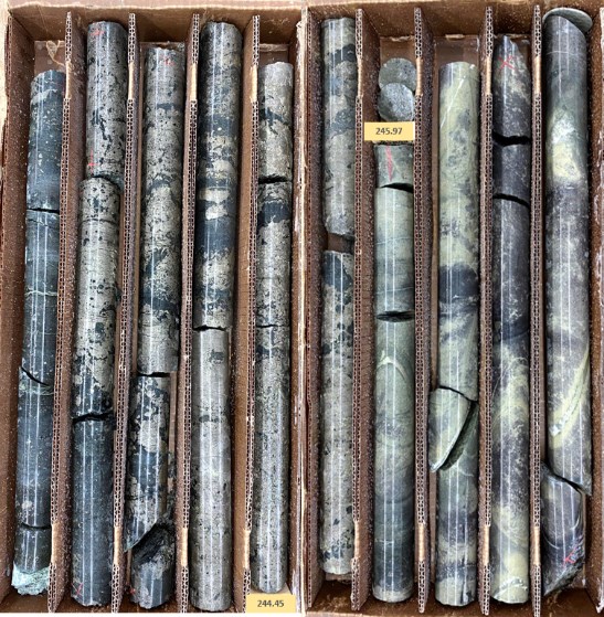
FIGURE 1: MASSIVE SULPHIDE MINERALIZATION STARTING AT 242.84 METERS (Drill hole 20TK0271)
To view an enhanced version of this graphic, please visit:
https://orders.newsfilecorp.com/files/2443/67319_f859dba4b4dd6959_002full.jpg
SUMMARY
As part of the Company's ongoing drilling program at the Tamarack Project, four (4) holes have been drilled in an area that represents a large step-out to the north of the Company's resource area, approximately 350 meters away. The area is referred to as the "CGO East" area, and is generally characterized by sheet-like massive sulphide mineralization that is typically up to 2.2 meters (7.2 feet) thick, grading up to 4% nickel, overlain by an additional thick sequence of disseminated sulphide mineralization that is typically 5 to 40 meters (16 to 131 feet) thick, grading between 0.5% - 0.8% nickel. The CGO East area is large, with the potential to host shallow, wide sheets of mineralization that may stretch over an area of 500 meters (east-west) by 900 meters (north-south).
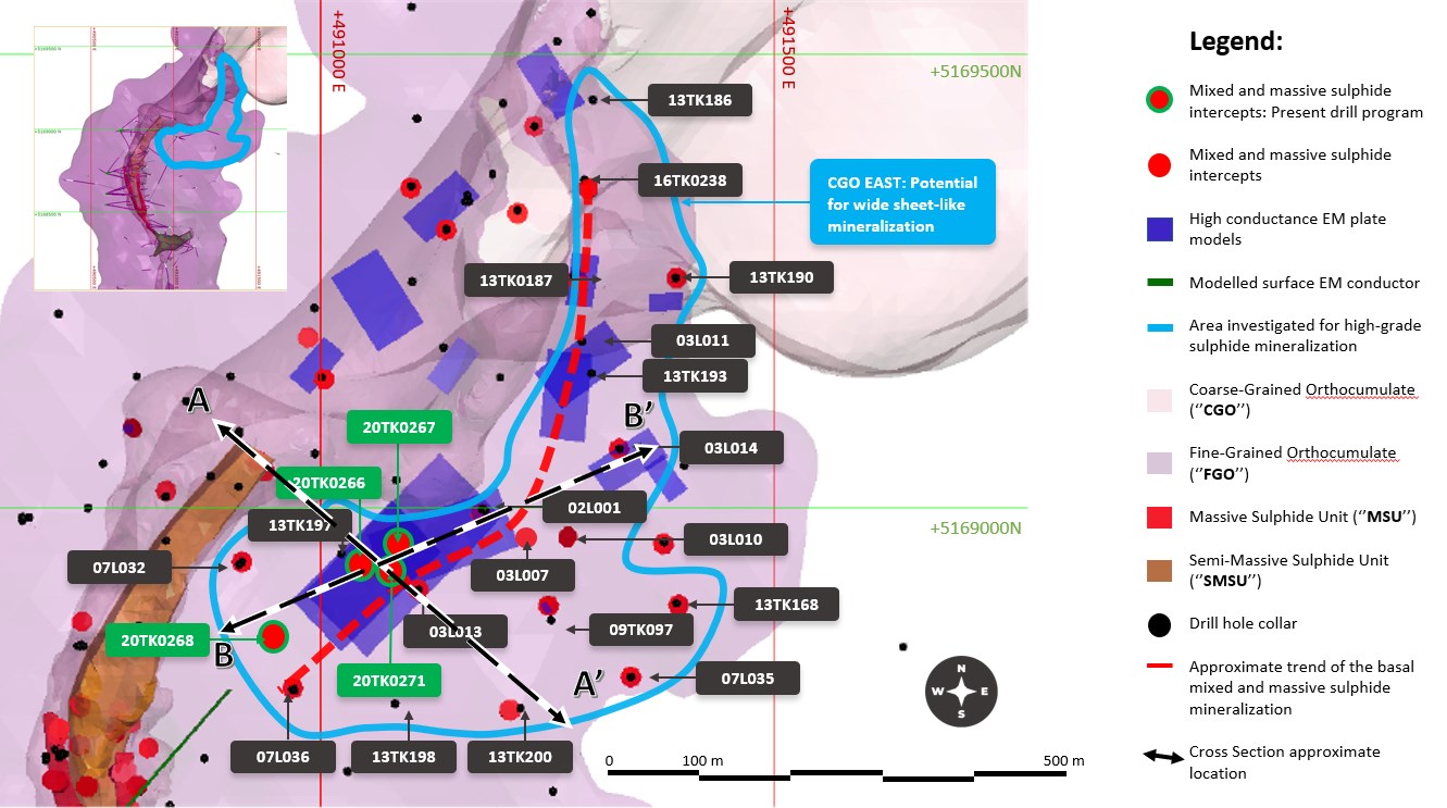
Figure 2: Plan view map of the CGO East mineralization. The solid blue line shows the potential extent of the sulphide mineralization in the area. The dashed red line represents an approximate 800 meter trend. A-A' segment shows the approximate location of the cross-section in Figure 3 below. B-B' shows the approximate location of the longitudinal section in Figure 4 below.
To view an enhanced version of this graphic, please visit:
https://orders.newsfilecorp.com/files/2443/67319_f859dba4b4dd6959_003full.jpg
The Company has focussed on this area for a number of key reasons, including:
- The mineralization within this area does not currently form part of the Company's current resource. If a resource can ultimately be delineated within this area, this could add significant tonnage to the Company's resource and mine plan, and also increase the mine life of the Tamarack Project.
- The mineralization within this area is shallow, with grades that have, so far, been above the Company's cut-off grade. If a resource can ultimately be delineated within this area, the mineralization could potentially be amenable to mining early in the mine life, and generate early cash flows as part of future mining operations.
TECHNICAL DISCUSSION
The drilling within the CGO East area has been focussed on a trend of approximately 800 meters (2,625 feet) that has been defined by a combination of geophysics and historical drill holes. Each end of the 800 meter trend is represented by drill holes 16TK0238 in the north and 07L036 in the south:
- Drill hole 16TK0238 intersected sulphide mineralization from 80 meters to 119.92 meters (total of 39.92 meters (131 feet) of mineralization), including 2.2 meters (7.2 feet) at 1.75% Ni, 0.89% Cu, 0.06% Co, 0.31 g/t PGE's + 0.12g/t Au, starting at 117.72 meters (2.26% NiEq[1] or 6.02% CuEq[2]). This drill hole is located approximately 900 meters from the Company's resource area.
- Drill hole 07L036 intersected sulphide mineralization in the form of basal massive sulphides, with 0.5 meters (1.6 feet) of 2.28% Ni, 1.54% Cu, 0.09% Co, 0.71g/t PGE's + 0.43 g/t Au, starting at 264.75 meters (3.21% NiEq or 8.57% CuEq). This drill hole is located approximately 230 meters from the Company's resource area.
Based on these previous drill results, the Company expects this 800 meter trend to be a parallel zone of mineralization, starting 250 meters away from the Company's current resource area.
The Company has completed four (4) drill holes in between these previous drill holes and along the 800 meter trend, with results thus far as follows:
- Drill hole 20TK0266 intersected sulphide mineralization from 203 meters to 247.75 meters (total of 44.75 meters (146.8 feet) of mineralization). To date, the Company has received partial assays for 11.75 meters (38.5 feet) at 1.03% Ni, 0.72 % Cu, 0.03 % Co, 0.14 g/t Pd, 0.31 g/t Pt and 0.25 g/t Au (1.50 % NiEq or 3.99 CuEq), starting at 236 meters, including 1.25 meters (4.1 feet) of 2.3% Ni, 1.09 %Cu, 0.09% Co, 0.15 g/t Pd, 0.27 g/t Pt and 0.3 g/t Au (2.98% NiEq or 7.96 % CuEq) starting 246.5 meters. Assays for the remainder of the mineralized interval remain pending.
- Drill hole 20TK0267 intersected sulphide mineralization from 224.33 meters to 249.02 meters (total of 24.69 meters (81 feet) of mineralization), including 1.94 meters (6.4 feet) of mixed and massive sulphides starting at 247.08 meters (assays pending).
- Drill hole 20TK0268 intersected sulphide mineralization from 287.12 to 312.59 meters (total of 25.07 meters (82 feet) of mineralization). The mineralization consists of patchy disseminated sulphides and mixed blebby sulphides from 312.19 to 312.59 meters (assays pending).
- Drill hole 20TK0269 was abandoned in overburden.
- Drill hole 20TK0271 intersected 2.59 meters (8.5 feet) of massive sulphide mineralization from 242.84 meters, within a larger mineralized interval of 20.98 meters (68.3 feet) from 234.64 meters to 245.55 meters (assays pending).
It is believed that the sheet-like mineralization within the CGO East area likely forms a mineralized channel where thicker intervals of basal massive sulphides have been observed (see Figure 2 above). In cross-section, drill holes 13TK0197, 20TK0266 (new hole), 20TK0271 (new hole) and drill hole 03L013 suggest a potential mineralization width of approximately 110 meters (361 feet) across the trend (see Figure 3 below).

Figure 3: Cross-section looking North-East of the CGO East area. The sulphide mineralization is located at the footwall of the Fine-Grained Orthocumulate (FGO) and the country rocks meta-sediments.
To view an enhanced version of this graphic, please visit:
https://orders.newsfilecorp.com/files/2443/67319_f859dba4b4dd6959_004full.jpg
In a longitudinal section, drilling has so far demonstrated 150 meters (492 feet) of strike-length of the 800 meter strike-length potential (see Figure 4 below)

Figure 4: Longitudinal section looking North-West of the CGO East area. The sulphide mineralization is located at the footwall of the Fine-Grained Orthocumulate (FGO) and the country rocks meta-sediments.
To view an enhanced version of this graphic, please visit:
https://orders.newsfilecorp.com/files/2443/67319_f859dba4b4dd6959_005full.jpg
TABLE 1: Summary of Drilling Results - CGO East mineralization
| Drill Hole | From | To | Length | Results | |||||||
| # | (m) | (m) | (m) | Ni (%) | Cu (%) | Co (%) | Pd (g/t) | Pt (g/t) | Au (g/t) | NiEq (%) | CuEq (%) |
| 20TK0266 | 203 | 236 | 33 | Assays pending | |||||||
| 20TK0266 | 236 | 247.75 | 11.75 | 1.03 | 0.72 | 0.03 | 0.14 | 0.31 | 0.25 | 1.5 | 3.99 |
| including | 246.5 | 247.75 | 1.25 | 2.3 | 1.09 | 0.09 | 0.15 | 0.27 | 0.3 | 2.99 | 7.96 |
| 20TK0267 | 224.33 | 249.02 | 24.69 | Assays pending | |||||||
| 20TK0268 | 287.12 | 312.59 | 25.07 | Assays pending | |||||||
| 20TK0271 | 224.64 | 247.75 | 20.98 | Assays pending | |||||||
Length refers to drill hole length and not True Width.
True Width is unknown at the time of publication.
All samples were analysed by ALS Minerals. Nickel, copper, and cobalt grades were first analysed by a 4-acid digestion and ICP AES (ME-MS61). Grades reporting greater than 0.25% Ni and/or 0.1% Cu, using ME-MS61, trigger a sodium peroxide fusion with ICP-AES finish (ICP81). Platinum, palladium and gold are initially analyzed by a 50g fire assay with an ICP-MS finish (PGM-MS24). Any samples reporting >1g/t Pt or Pd trigger an over-limit analysis by ICP-AES finish (PGM-ICP27) and any samples reporting >1g/t Au trigger an over-limit analysis by AAS (Au-AA26).
NiEq% = Ni%+ Cu% x $3.00/$8.00 + Co% x $12.00/$8.00 + Pt [g/t]/31.103 x $1,300/$8.00/22.04 + Pd [g/t]/31.103 x $700/$8.00/22.04 + Au [g/t]/31.103 x $1,200/$8.00/22.04
CuEq% = Cu%+ Ni% x $8.00/$3.00 + Co% x $12.00/$3.00 + Pt [g/t]/31.103 x $1,300/$3.00/22.04 + Pd [g/t]/31.103 x $700/$3.00/22.04 + Au [g/t]/31.103 x $1,200/$3.00/22.04
Quality Assurance, Quality Control and Qualified Persons
Please see the technical report entitled "NI 43-101 Technical Report Updated Preliminary Economic Assessment (PEA) of the Tamarack North Project - Tamarack, Minnesota" with an effective date of March 12, 2020 prepared by independent "Qualified Persons" (as that term is defined in National Instrument 43-101 ("NI 43-101") Leslie Correia (Pr. Eng), Andre-Francois Gravel (P. Eng.), Tim Fletcher (P. Eng.), Daniel Gagnon (P. Eng.), David Ritchie (P. Eng.), Oliver Peters (P. Eng.), Christine Pint (P.G.) and Brian Thomas (P. Geo.) for information on the QA/QC, analytical and testing procedures at the Tamarack Project. Copies are available on the Company's website (www.talonmetals.com) or on SEDAR at (www.sedar.com). The laboratory used is ALS Minerals who is independent of the Company.
Lengths are drill intersections and not necessarily true widths. True widths cannot be consistently calculated for comparison purposes between holes because of the irregular shapes of the mineralized zones. Drill intersections have been independently selected by Talon. Drill composites have been independently calculated by Talon. The geological interpretations in this news release are solely those of the Company.
The locations and distances highlighted on all maps in this news release are approximate.
Dr. Etienne Dinel, Vice President, Geology of Talon, is a Qualified Person within the meaning of NI 43-101. Dr. Dinel is satisfied that the analytical and testing procedures used are standard industry operating procedures and methodologies, and he has reviewed, approved and verified the technical information disclosed in this news release, including sampling, analytical and test data underlying the technical information.
About Talon
Talon is a TSX-listed base metals company in a joint venture with Rio Tinto on the high-grade Tamarack Nickel-Copper-Cobalt Project located in Minnesota, USA, comprised of the Tamarack North Project and the Tamarack South Project. Talon has an earn-in to acquire up to 60% of the Tamarack Project. The Tamarack Project comprises a large land position (18km of strike length) with numerous high-grade intercepts outside the current resource area. Talon is focused on expanding its current high-grade nickel mineralization resource prepared in accordance with NI 43-101; identifying additional high-grade nickel mineralization; and developing a process to potentially produce nickel sulphates responsibly for batteries for the electric vehicles industry. Talon has a well-qualified exploration and mine management team with extensive experience in project management.
For additional information on Talon, please visit the Company's website at www.talonmetals.com or contact:
Sean Werger
President
Talon Metals Corp.
Tel: (416) 361-9636 x102
Email: werger@talonmetals.com
Forward-Looking Statements
This news release contains certain "forward-looking statements". All statements, other than statements of historical fact that address activities, events or developments that the Company believes, expects or anticipates will or may occur in the future are forward-looking statements. These forward-looking statements reflect the current expectations or beliefs of the Company based on information currently available to the Company. Such forward-looking statements include statements relating to the timing and results of the exploration program, including assay results, grades, drilling plans and the use of a second drill rig; the potential to add significant tonnage to the Company's resource and mine plan; the potential for an increase in the mine life and the generation of early cash flows; and the potential for a new parallel zone of shallow mineralization, starting 250 meters away from the Company's current resource area. Forward-looking statements are subject to significant risks and uncertainties and other factors that could cause the actual results to differ materially from those discussed in the forward-looking statements, and even if such actual results are realized or substantially realized, there can be no assurance that they will have the expected consequences to, or effects on the Company.
Any forward-looking statement speaks only as of the date on which it is made and, except as may be required by applicable securities laws, the Company disclaims any intent or obligation to update any forward-looking statement, whether as a result of new information, future events or results or otherwise. Although the Company believes that the assumptions inherent in the forward-looking statements are reasonable, forward-looking statements are not guarantees of future performance and accordingly undue reliance should not be put on such statements due to the inherent uncertainty therein.
Table 2: New Drill Hole Quick Lithology Logs
| Hole ID | From (m) | To (m) | Length (m) | Lithology | % Sulphides |
| 20TK071 | 0 | 37.34 | 37.34 | Overburden | |
| 37.34 | 224.64 | 187.3 | FGO/MZNO | Traces | |
| 224.64 | 242.93 | 18.29 | FGO/MZNO | 5 to 20% | |
| 245.06 | 247.75 | 2.69 | MSU | 85% | |
| 247.75 | 299.62 | 51.87 | SED | ||
| 20TK0268 | 0 | 43.59 | 43.59 | Overburden | |
| 43.59 | 287.12 | 243.53 | FGO/MZNO | Traces | |
| 287.12 | 312.19 | 25.07 | FGO/MZNO | 2-10% | |
| 312.19 | 312.59 | 0.4 | FGO/MZNO | 25% | |
| 312.59 | 388.77 | 76.18 | SED |
Table 2: Quick lithology log of drill holes 20TK0271 and 20TK0268 (Fine-grained orthocumulate/Mixed Zone (FGO/MZNO); Mixed massive sulphides (MMS); Massive sulphides (MSU); Meta-sedimentary rocks (SED)
Table 3: Collar Locations of Historical Drill Holes in CGO East Area
| CGO EAST | ||||||
| HOLEID | Easting (m) | Northing (m) | Elevation (masl) | Azm | Dip | End Depth (m) |
| 20TK0266 | 491022.0 | 5168949.1 | 388 | 110.0 | -82.5 | 283.5 |
| 20TK0267 | 491021.2 | 5168949.1 | 388 | 78.7 | -70.1 | 295.5 |
| 20TK0268 | 491021.9 | 5168951.8 | 388 | 218.05 | -66.17 | 388.77 |
| 20TK0269 | 491022.0 | 5168949.0 | 388 | Hole abandoned | ||
| 20TK0270 | 490738.0 | 5168854.0 | 388 | 336.28 | -83.11 | 347.62 |
| 20TK0271 | 491019.0 | 5168955.0 | 388 | 111.02 | -78.49 | 299.62 |
Collar coordinates are UTM Zone 15N, NAD83.
Azimuth and Dip are downhole survey averages for the hole.
For daughter holes; collar coordinates and elevations are same as mother hole; approximate wedge depth given; azimuth and dip are the survey averages below the wedge.
[1] Where used in this news release NiEq% = Ni%+ Cu% x $3.00/$8.00 + Co% x $12.00/$8.00 + Pt [g/t]/31.103 x $1,300/$8.00/22.04 + Pd [g/t]/31.103 x $700/$8.00/22.04 + Au [g/t]/31.103 x $1,200/$8.00/22.04
[2] Where used in this news release CuEq% = Cu%+ Ni% x $8.00/$3.00 + Co% x $12.00/$3.00 + Pt [g/t]/31.103 x $1,300/$3.00/22.04 + Pd [g/t]/31.103 x $700/$3.00/22.04 + Au [g/t]/31.103 x $1,200/$3.00/22.04
To view the source version of this press release, please visit https://www.newsfilecorp.com/release/67319