Exciting Large-Scale Target in Sulphide Zone Confirmed by Geophysics at Marimaca
VANCOUVER, British Columbia, July 14, 2020 (GLOBE NEWSWIRE) -- Marimaca Copper Corp. (“Marimaca Copper” or the “Company”) (TSX: MARI) is pleased to announce the results of a high resolution, drone mounted, magnetic survey at the Company’s flagship Marimaca Copper Project (“Marimaca” or “the Project”) in Chile. This work follows on from the updated geological interpretation for Marimaca (refer to release 8 June 2020), which indicates strong potential for sulphide mineralization beneath the Marimaca Oxide Deposit (“MOD”).
Highlights
- Large magnetic anomaly, which provides a copper sulphide target for follow-up exploration, located underneath the MOD, within the interpreted extensions of the same structures that host copper mineralization at surface
— Total volume of the favourable magnetic anomaly is approximately 175 million cubic metres
— Equivalent to circa 475 million tonnes assuming an average specific gravity of 2.7g/cm³ - Magnetic susceptibility testing of drill samples from Marimaca and a review of key geological and mineralogical features shows strong relationship between chalcopyrite and magnetite mineralization at depth
- Deeper drilling at Marimaca encountered broad zones of higher-grade sulphide material immediately adjacent to, or at the border of, the new interpreted magnetic anomaly
- The next step, prior to drilling, is to confirm the existence of sulphide related to the magnetite bodies by means Induce Polarization / Resistivity lines crossing the magnetic anomaly
- Success of drone mounted magnetic survey provides impetus to extend surveys to cover the area surrounding Marimaca to target potential repetitions of similar style mineralization
The drone mounted magnetic survey identified a significant magnetic anomaly beneath the current MOD, which dips to the east with the same geometry as the interpreted extension of the surface structures that host the copper mineralization at Marimaca. The strong correlation of the magnetic response and the primary sulphide bearing mineralized zones (mainly chalcopyrite), which was identified during the magnetic susceptibility testing of drill samples from Marimaca, provides a clear indication of a major copper sulphide target. The total volume of the magnetic anomaly, as generated by the Geosoft’s™ Magnetic Vector Inversion modelling method, is approximately 175 million cubic metres, which equates to approximately 475 million tonnes assuming a specific graphic of 2.7g/cm3.
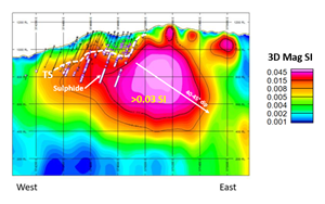
Figure 1: Cross Section with Interpreted Sulphide Zone, Previously Completed Sulphide Drill Results and Vector Inversion Magnetic Anomaly > 0.03 SI:
https://www.globenewswire.com/NewsRoom/AttachmentNg/bd116ea6-7bf6-4839-9ec6-38886a15890d
Sergio Rivera, VP Exploration of Marimaca Copper commented:
“The results of this magnetic survey, which have provided stunning clarity with respect to the magnetic anomaly and large structures around the Marimaca deposit, have confirmed our interpretation of the potential for down dip extensions at Marimaca. We are excited by this potential and will look to complete a complementary Induced Polarization/Resistivity survey to further assist in targeting sulphide mineralization.
“These results build on the exceptional work of our geological team in identifying geological markers which we hope will help us to target additional oxide and sulphide zones in the future. The application of this modern geophysical tool, combined with our largely completed geological mapping and geochemistry, will provide the groundwork for identifying interesting anomalies for follow-up exploration work.”
Marimaca Copper Project Overview
As previously announced, the Company released an updated Mineral Resource Estimate (“MRE”) for Marimaca of 70 million tonnes, with an average grade of 0.60% copper, within the Measured & Indicated Categories (approximately 420Kt of contained copper) and 40 million tonnes, with an average grade of 0.52% copper, within the Inferred Category (approximately 224kt of contained copper) (refer to release 2 December 2019). This represents an increase of almost 100% from the MRE released in April 2018 and makes the Project one of the most significant copper oxide discoveries in Chile in the last decade.
The Company is currently undertaking a PEA for the Project, which is anticipated to be released in the coming weeks. The Project is expected to benefit from low upfront capital development costs and, due to the favourable geometry of the orebody and relatively simple oxide processing through SX-EW, Management believes the Project will have very competitive operating costs, delivering compelling economics in the PEA.
Summary of Geology and Ongoing Exploration Potential
Geological Interpretation
The Marimaca Copper Project is interpreted to be a medium-high level exposed Iron-Oxide Copper Gold (“IOCG”) deposit. It comprises a dominant structural feature of broad areas of sheeted dykes and fracture zones, oriented north-north-east and dipping 45-60° to the east (see Figure 2), which host the copper mineralisation at surface.
The MOD has been extensively drilled and the surrounding area has been covered by detailed surface mapping and geochemical sampling. The Company completed a lower resolution magnetic survey in 2016, followed by a high-resolution drone mounted earlier this year which showed magnetic anomalies fairly coincident with the broader MOD. This has provided a large base of information from which geological interpretations can be made. Based on the recent reassessment of the geological model for Marimaca (refer to release 8 June 2020) the Company believes it has the potential for significant sulphide mineralization at depth. Furthermore, the interpretation of its genesis being the result of in-situ oxidation of primary copper sulphides, with a low pyrite content, suggests that the grades in the sulphide zone would in the same range as observed for the MOD.
Figure 2: Marimaca Deposit East Dipping Sheeted Fractures Controlling Mineralization (looking North):
https://www.globenewswire.com/NewsRoom/AttachmentNg/f3ba27b5-e519-4b46-bf33-b8240307c4cb
Marimaca benefits from nearly 90,000 metres of drilling, which provides large quantities of data to build a detailed geological model. A review of the structure of the deposit, obtained from surface mapping and core from diamond drilling completed at Marimaca, shows that the structural controls of the mineralization continue in the deeper parts of the deposit, perhaps extending to considerable depths.
In addition, several of the deeper drill holes at Marimaca, completed during the Phase II resource drilling program, intercepted sulphide mineralization below the MOD resource area. These results (refer to release 8 June 2020) highlighted broad zones of higher-grade copper sulphide mineralization including:
- 42 metres averaging 0.57% CuT from 272m downhole in ATR-30;
- 26 metres averaging 0.97% CuT from 178m downhole in ATR-78;
- 16 metres averaging 1.40% CuT from 122m downhole in ATR-79;
- 44 metres averaging 1.05% CuT from 206m downhole in ATR-82;
- 26 metres averaging 0.84% CuT from 148m downhole in ATR-84;
- 36 metres averaging 1.68% CuT from 84m downhole in ATR-85;
- 38 metres averaging 1.04% CuT from 180m downhole in ATR-93; and
- 48 metres averaging 1.30% CuT from 78m downhole in ATR-94.
Magnetic Susceptibility Measurements and Relationship with Primary Copper Sulphides
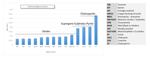
A strong relationship between chalcopyrite and magnetite is observed throughout the deposit area. The Company has completed magnetic susceptibility work on over 42,800 samples representing 85km of available drilling. The results, which have been analysed on the basis of rock types as well as mineral sub-zones across the Marimaca deposit, show a clear correlation of high- magnetic susceptibility in the zones with primary sulphide and the feeder zones associated with this mineralization as compared to the oxide zones (see Figure 3).
Of the dataset analysed, the 1,458 samples which included chalcopyrite mineralization show a mean magnetic susceptibility significantly greater than the other mineral subzones of the Project. This observation was also true for other sulphides including covellite and chalcocite.
Figure 3: Summary of Magnetic Susceptibility Analysis by Mineral Completed on Drill Core from Marimaca:
https://www.globenewswire.com/NewsRoom/AttachmentNg/4cfcce87-9004-4ce2-b1bc-7a5d44441e80
Magnetic Survey Results
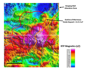
The Company completed a drone mounted, high resolution, magnetic survey over an area of 2km by 2km which is directly coincident with the MOD and its immediate surrounding area. The survey was completed on 25m line spacings oriented east-west with north-south control lines every 250m, and with an average flight altitude of 20m above the ground, for a total of 1,600 line kilometres of survey data (see Figure 4).
Figure 4: Pole Reduced Drone Mag Results on 2km x 2km Area over Marimaca Copper Project with location of main dykes and structures and the >0,1% CuT oxide surface outline. Cross section from Figures 1 and 5 is located for reference:
https://www.globenewswire.com/NewsRoom/AttachmentNg/71843d66-0683-4d47-b32f-53a2c721c464
The results show a large magnetic anomaly adjacent to and underlying the current MOD Mineral Resource Estimate (“MRE”) area. The magnetic anomaly, which extends to circa 700m below the MOD MRE area, appears to be controlled or truncated by the late stage, west-northwest trending Manolo fault. The magnetic anomaly also appears oriented on a north-south to north-north east strike, which is consistent with the strike of the MOD at surface.
In the following cross section obtained from the Magnetic Vector Inversion (Geosoft™) Model , it can clearly be seen that the magnetic anomaly dips to the east with an angle of approximately 45 degrees, which is consistent with the structures observed in surface mapping and also in the deeper diamond drilling completed at Marimaca, which show structures dipping to the east at between 45 and 60 degrees. The sulphide intercepts, which are shown in Figure 5 in white, appear to be immediately adjacent to the magnetic anomaly.
Figure 5: Cross Section Showing Down Dip Extension of Magnetic Anomaly:
https://www.globenewswire.com/NewsRoom/AttachmentNg/4d1ddb99-a773-48f6-a198-ad7f15bed693
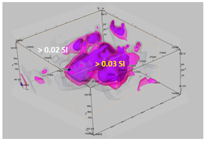
The 25m spacing and low flight altitude has allowed the creation of a detailed 3-Dimensional interpretation of magnetic anomaly in the Project area. Based on this interpretation, the total volume of the magnetic anomaly which provides a target to follow-up for copper sulphide exploration, with greater than 0.03 SI, is approximately 175 million cubic metres, which equates to a tonnage of circa 475 million tonnes assuming a specific gravity of 2.7g/cm³.
Figure 6: 3-Dimensional View of Magnetic Anomaly > 0.03 SI as obtained from the Magnetic Vector Inversion (Geosoft™) Model Looking North-East:
https://www.globenewswire.com/NewsRoom/AttachmentNg/1afaaa1e-14ff-4800-9ba7-4caa5704d75c
Qualified Persons
The technical information in this news release, including the information that relates to geology, drilling and mineralization was prepared under the supervision of, or has been reviewed by Sergio Rivera, Vice President of Exploration, Marimaca Copper Corp, a geologist with more than 36 years of experience and a member of the Colegio de Geologos de Chile and of the Institute of Mining Engineers of Chile, and who is the Qualified Person for the purposes of NI 43-101 responsible for the design and execution of the drilling program.
The Qualified Person for content other than geological information in this news release is Luis Tondo, Chief Executive Officer and Director of Marimaca Copper, a mining engineer with more than 30 years of experience and a Fellow of The Australasian Institute of Mining and Metallurgy, who is the Qualified Person for the purposes of NI 43-101.
Both QPs confirm that they have visited the Marimaca Project on numerous occasions, are responsible for the information contained in this news release and consent to its publication.
Marimaca Copper and the Marimaca Project
Marimaca is fast becoming recognised as one of the most significant copper discoveries in Chile in recent years as it represents a new type of deposit which challenges accepted exploration wisdom and promises to open up new frontiers for discoveries elsewhere in the country. Marimaca is hosted by intrusive rocks while the numerous manto deposits in the same region are hosted by volcanics. With a lack of new copper exploration discoveries in Chile, the growing Marimaca resource is a high-profile development project as it is situated in the coastal belt at low elevation close to Antofagasta and Mejillones. This prime location could enable its future development at a relatively modest capital investment. Marimaca will benefit from nearby existing infrastructure including roads, powerlines, ports, a sulphuric acid plant, a skilled workforce and seawater.
Contact Information
For further information please visit www.marimaca.com or contact:
Tavistock
+44 (0) 207 920 3150
Jos Simson/Emily Moss
marimaca@tavistock.co.uk
Forward Looking Statements
This news release includes certain “forward-looking statements” under applicable Canadian securities legislation. These statements relate to future events or the Company’s future performance, business prospects or opportunities. Forward-looking statements include, but are not limited to, the impact of a rebranding of the Company, the future development and exploration potential of the Marimaca Project. Actual future results may differ materially. There can be no assurance that such statements will prove to be accurate, and actual results and future events could differ materially from those anticipated in such statements. Forward-looking statements reflect the beliefs, opinions and projections on the date the statements are made and are based upon a number of assumptions and estimates that, while considered reasonable by Marimaca Copper, are inherently subject to significant business, economic, competitive, political and social uncertainties and contingencies. Many factors, both known and unknown, could cause actual results, performance or achievements to be materially different from the results, performance or achievements that are or may be expressed or implied by such forward-looking statements and the parties have made assumptions and estimates based on or related to many of these factors. Such factors include, without limitation: risks related to share price and market conditions, the inherent risks involved in the mining, exploration and development of mineral properties, the uncertainties involved in interpreting drilling results and other geological data, fluctuating metal prices, the possibility of project delays or cost overruns or unanticipated excessive operating costs and expenses, uncertainties related to the necessity of financing, the availability of and costs of financing needed in the future as well as those factors disclosed in the Company’s documents filed from time to time with the securities regulators in the Provinces of British Columbia, Alberta, Saskatchewan, Manitoba, Ontario, New Brunswick, Nova Scotia, Prince Edward Island and Newfoundland and Labrador. Accordingly, readers should not place undue reliance on forward-looking statements. Marimaca Copper undertakes no obligation to update publicly or otherwise revise any forward-looking statements contained herein whether as a result of new information or future events or otherwise, except as may be required by law.


