Group Ten Reports 8 Meters of 3.65 g/t Platinum, Palladium, and Gold, and 26.8m of 0.98% Nickel and 0.45% Copper, in Drill Results from the Iron Mountain Target Area of the Stillwater West Project in Montana, USA
VANCOUVER, British Columbia, May 07, 2019 (GLOBE NEWSWIRE) -- Group Ten Metals Inc. (TSX.V: PGE; US OTC: PGEZF; FSE: 5D32) (the “Company” or “Group Ten”) announces results from the Iron Mountain target area on the east side of the Stillwater West PGE-Ni-Cu Project, adjacent to Sibanye-Stillwater’s high-grade Platinum Group Element (“PGE”) mines in Montana, USA. This is the fourth in a series of planned news releases to report results of 2018 exploration programs and on-going data synthesis and modeling work at the Company’s flagship project. Highlights include:
- Past shallow drilling at the HGR target includes 8.0 meters of 3.65 g/t platinum, palladium and gold, plus 0.16% combined nickel and copper and 0.013% cobalt for 4.46 g/t total platinum equivalent (“TotPtEq”) or 1.08% total nickel equivalent (“TotNiEq”), starting at surface. Mineralization in this interval is directly comparable to the observed grades on Platreef deposits in the Bushveld Complex of South Africa at Anglo American’s Mogalakwena Mine and Ivanhoe’s Platreef Mine, in a similar geological setting;
- Deeper drilling in the 1970s at the HGR target returned long intervals of nickel-copper sulphide mineralization - which were not sampled at the time for other metals including PGEs - intercepting 259.1 meters grading 0.25% Ni and 0.20% Cu (0.35% TotNiEq or 1.44 g/t TotPtEq), starting at 15.2 meters depth and ending in mineralization, including 26.8 meters at 0.98% Ni and 0.45% Cu (1.21% TotNiEq or 4.96 g/t TotPtEq) in Hole 355-64;
- Re-sampling of core from 1970s drill holes at the HGR target reports palladium values from intercepts of significant nickel-copper sulphide mineralization ranging up to 2.7 g/t in Hole 355-64. Additional drilling is required to better define the content of PGEs and other target commodities at the HGR target;
- 2018 and historic rock samples returned high-grade results with 17 samples over 2 g/t PGE plus gold, ranging up to 95.8 g/t platinum, palladium, and rhodium (27.8 g/t Pt, 62.2 g/t Pd, 5.78 g/t Rh) at the HGR target.
- Past drilling at the HGR target defines an approximately 750 meter by 400 meter area within a larger area defined by coincident geophysical (conductive high) and geochemical soil anomalies that appears to connect with similar anomalies at the Iron Mountain Central target about one kilometer to the west. The HGR target is open for expansion in all directions, including to the east in the direction of an adjacent kilometer-scale geophysical conductive high anomaly that remains untested, and to the west along the layered stratigraphy of the Stillwater Complex towards the Iron Mountain Central target; and
- Results confirm that the geophysical conductive highs are targeting high-sulphide mineralization, and that the scale of the conductive anomalies is comparable to deposits at Platreef. The Iron Mountain target area is a priority for follow-up work in 2019 based on the potential to rapidly expand known mineralized zones.
Michael Rowley, President and CEO, commented, "The Iron Mountain target includes some of the most compelling examples to date of the potential we see across the 25-kilometer-long Stillwater West Project, with multiple long intervals of nickel and copper sulphide mineralization including thick intercepts enriched in platinum, palladium, cobalt, gold, and rhodium. Drill data compiled and modeled by Group Ten report 33 intervals with over 50 gram-meter Total Platinum Equivalent (TotPtEq) grade-thickness, and 13 with over 100 gram-meter TotPtEq, in the Iron Mountain target area, with many holes beginning and ending in mineralization.
“Shallow, more recent drill holes show grades comparable to deposits at Platreef over significant widths, including multi-gram per tonne platinum, palladium, and gold, along with nickel, copper and cobalt values, starting at surface. Deeper drilling from the 1970s demonstrates wide intervals of nickel and copper sulphide mineralization with associated PGEs that were previously only selectively sampled. Taken together, the drilling and surface sampling at the Iron Mountain target area demonstrate the presence of Platreef-style grade with potential bulk tonnage scale at Stillwater West. Drill-defined mineralization at the HGR and Central targets is open for expansion in all directions, including to the east towards a geophysical conductor that has never been drill tested, and to the west following the magmatic layers of the Stillwater Complex.
“The Iron Mountain target area, along with the Chrome Mountain and Camp Zone target areas, is a top priority for work in 2019 as we see the potential to rapidly expand known mineralization and quickly advance targets to resource delineation stage. We look forward to reporting further updates in the very near future.”
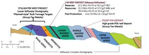
Figure 1 – Cross-Section Through the Stillwater Igneous Complex Showing the
Layered Stratigraphy and Known Deposits
A photo accompanying this announcement is available at http://www.globenewswire.com/NewsRoom/AttachmentNg/d948c803-a326-4956-ae43-42e260bf5d9c
Iron Mountain Overview
The 2018 exploration program, the Company’s first at Stillwater West, focused on exploration of the lower Stillwater Complex (Figure 1) where Group Ten sees the potential for much larger mineralized systems than has been previously recognized in the district based on work to date and known geological similarities between the Stillwater Igneous Complex and the Bushveld Igneous Complex in South Africa. The northern limb of the Bushveld, a region known as the Platreef, has seen rapid development as a world leader in low-cost platinum and palladium supply since the 1990s with the discovery and development of Anglo American’s Mogalakwena PGE-Ni-Cu Mine, and Ivanhoe’s Platreef PGE-Ni-Cu mine that is now construction.
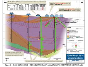
Group Ten is targeting a “Platreef-style” setting in which bulk-tonnage sulphide mineralization in the Lower Stillwater Complex may be associated with interaction between the layered magmatic system and the basement country rocks. Interaction and assimilation of basement country rocks is an important component of the Platreef deposits in the Bushveld Complex, where the country rocks may be in place as the footwall or occur as large rafts within the layered magmatic stratigraphy. The potential for this setting at Iron Mountain is supported by deep conductive geophysical targets at the two most advanced targets, being the Iron Mountain Central and HGR targets. A series of deeper drill holes at the HGR target demonstrate further potential by drilling through iron formation, in what had been interpreted as basement country rocks, before returning to mineralized layered ultramafic rocks below (see cross-section in Figure 8).
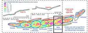
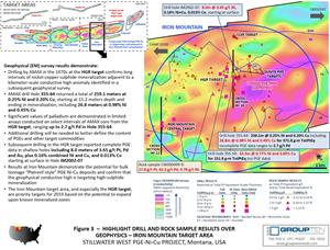
As shown in Figure 2, the approximately 2.9-kilometer-wide Iron Mountain target area is one of eight major target areas identified by Group Ten as having potential for large PGE-Ni-Cu Platreef-style deposits across the Ultramafic and Basal Series of the Stillwater Complex. These target areas are highlighted by strong, multi-kilometer electro-magnetic conductive signatures that are characteristic of large bodies of interconnected to strongly disseminated sulphides. The presence of significant nickel and copper sulphide mineralization corresponding to, and associated with, the electromagnetic conductors within these target areas is confirmed in historic drill results compiled by the Company. Assay data is less comprehensive for other elements, although thick intervals enriched in platinum, palladium, gold, cobalt and chromium are demonstrated in target areas where data exists. No systematic drill test of the conductive high geophysical anomalies has been conducted to date in the Iron Mountain target area (see Figure 3).
Figure 2 – Fourteen Target Areas Across the 25-Kilometer Length of the Stillwater West Project
A photo accompanying this announcement is available at http://www.globenewswire.com/NewsRoom/AttachmentNg/2713671e-1124-42c6-8922-6dd9960cd05e
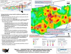
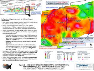
The potential for significant PGE-Ni-Cu deposits is further strengthened by the correlation of the conductive geophysical targets with highly elevated levels of platinum, palladium, gold, nickel, copper, and chromium in soils and rock sampling across much of the Stillwater West Project. Soil geochemistry results for the Iron Mountain target area are presented in Figures 4 and 5.
Tables 1 and 2 summarize data from 46 drill holes within the Iron Mountain target area which demonstrate strong mineralization with 13 drill holes returning intercepts of greater than 100 gram-meter TotPtEq grade-thickness (or 24 percent-meter TotNiEq). Grade-thickness values are based solely on nickel and copper data in six of those holes, including Hole 355-64 which was drilled in 1976 at the HGR target and returned an exceptional 371.8 gram-meter TotPtEq (or 90.7 percent-meter TotNiEq). Grade-thickness values, determined as grade x thickness, of 25 gram-meter or more are considered economically significant, and values of 100 to 300 gram-meter are considered exceptional. Grade-thickness values at the adjacent J-M Reef mines average approximately 34 gram-meter palladium and platinum1.
Rock sample results from the Iron Mountain target area confirm the presence of significant platinum, palladium, nickel, copper and cobalt mineralization with 17 samples over 2 g/t PGE plus gold - and four over 10 g/t PGE plus gold - ranging to 95.8 g/t combined platinum, palladium, and rhodium in one sample at the HGR target (Table 3). In addition, test work indicates a consistent ratio of rhodium content relative to platinum values, with 13 samples returning rhodium results of 0.47 g/t or higher. Rhodium values have not been included in the calculation of metal equivalents in the tables above and below.
HGR Target
The HGR target is the most advanced within the Iron Mountain target area, with 21 drill holes returning over 25 gram-meter TotPtEq grade-thickness within an approximately 750 meter by 400 meter area within a larger area defined by coincident geophysical (conductive high) and geochemical soil anomalies that is open in all directions and appear to connect with similar anomalies at the Iron Mountain Central target (see Figures 3 to 5). Mineralized intervals range from 26.7 to 259.1 meters across these holes at grades ranging from 0.12% to 1.43% combined nickel and copper, with an average length of 94 meters at 0.2 6% combined nickel and copper. Assay data for other commodities are limited as the older, deeper holes were generally assayed only selectively for nickel and copper, although subsequent PGE assays were completed on select intervals. Shallower, more recent holes provide complete assay data.
Ten AMAX drill holes from the 1970s intersected significant intervals of nickel and copper sulphide mineralization near the Basal contact of the Stillwater Complex, including Hole 355-59 which returned 33.5 meters of 0.77% Ni and 0.65% Cu. Hole 355-64, drilled approximately 160 meters south of 355-59, returned 26.8 meters of 0.98% Ni and 0.45% Cu within a broader interval of 259.1 meters of 0.25% Ni and 0.20% Cu that starts at 15.2 meters depth and ends in mineralization (see Table 1 and cross-section in Figure 8). Although AMAX did not systematically analyze for PGEs, subsequent work reported values ranging up to 2.7 g/t Pd in Hole 355-64. Based on the observed ratio of platinum to palladium in drill core with complete assay results in the HGR target area, total PGE values are projected to range be approximately 4 g/t for this sample.
Eighteen more recent holes provide valuable confirmation of the PGE potential of the HGR target by reporting complete assay data including 8.0 meters of 3.65 g/t 3E and 0.14% Ni, 0.03% Cu and 0.013% Co starting at surface in Hole IM2002-07, an 84.5-meter hole drilled in 2002 about 110 meters from 355-64. Hole IM2002-07 is also about 60 meters from Hole 355-62, which returned 220.8 meters of 0.16% Ni and 0.03% Cu.
The PGE potential of the HGR target area is further confirmed by Hole IM2002-12 which returned 4.1 meters of 3.09 g/t PGE+Au plus 0.14% Ni, 0.02% Cu, and 0.009% Co.
The HGR target area is a priority for work in 2019 as it demonstrates the widest and highest-grade mineralization intercepted to date at Stillwater West, with grades that are directly comparable to the Platreef. HGR shows excellent potential to advance quickly to resource delineation stage with further drilling at known mineralized zones that are open at depth and along strike, where Group Ten is targeting areas to the east and west, outside of the core HGR target area as defined by drilling to date. To the east, the Company is targeting a kilometer-scale conductive high anomaly identified in a subsequent geophysical survey that remains untested (see Figure 3).
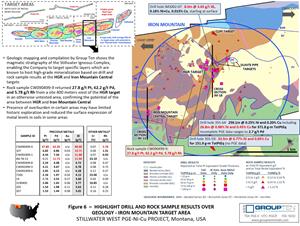
The area west of the HGR target area also remains untested and is highly prospective with rock sample results of up to 27.8 g/t platinum, 62.2 g/t palladium, and 5.78 g/t rhodium in one sample taken about 400 meters west of the HGR target, towards the Iron Mountain Central target. Geologic compilation and mapping by Group Ten, as summarized in Figure 6, demonstrates that the layered magmatic stratigraphy of the Stillwater Complex runs laterally through both target areas, potentially connecting the high-grade results within specific layers at both targets and highlighting the potential of the area in between, which has not been drill tested.
Iron Mountain Central Target
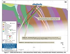
Work to date at the Iron Mountain Central target centers on three drill holes with over 100 gram-meter TotPtEq grade-thickness in long intervals of platinum, palladium, gold, and cobalt in nickel and copper sulphide mineralization: IM2007-01 returned 226.2 meters at 226.1 gram-meter TotPtEq; IM2007-02 returned 123.5 meters at 130.1 gram-meter TotPtEq; and IM2007-03 returned 124.4 meters at 127.0 gram-meter TotPtEq (see Table 1). Consistent cobalt values of 0.013% to 0.016% are shown across these intervals, adding potentially significant co-product value.
The Iron Mountain Central target is open for expansion to the east towards the HGR target where an area approximately one kilometer by 640 meters returned highly elevated platinum, palladium and gold levels in soil that are coincident with a geophysical conductive high anomaly that remains untested (Figures 3 and 4). A much larger nickel and copper in soil anomaly is also shown across the area, following the broader Peridotite Zone (Figure 5). In addition, geological mapping and modeling work by Group Ten has targeted specific layers of the stratigraphy within the complex for high-grade mineralization based on known results at both Iron Mountain Central target and the HGR target to the east, generating compelling targets on the intervening ground.
Intrusive Dunite Targets
Geologic mapping by the Company in 2018 identified multiple intrusive dunites across the Stillwater West Project, including the Iron Mountain target area (see Figures 3 to 6). Intrusive dunites formed the first mines in South Africa’s Bushveld Igneous Complex and were known for their spectacular PGE grades, along with other commodities. No systematic exploration has been completed for intrusive dunites at in the Stillwater Complex, although occurrences have been noted in past geophysical and geological sampling surveys. Follow up of these targets is a priority for Group Ten based on their potential for both grade and size.
| Table 1 – Drill Results, HGR Target at Iron Mountain | ||||||||||||||
| INTERVAL | PRECIOUS METALS | BASE METALS | TOTAL METAL EQUIVALENTS | GRADE THICKNESS | ||||||||||
| HOLE ID | From | To | Width | Pt | Pd | Au | 3E | Ni | Cu | Co | NiEq | TotPtEq | TotNiEq | Grade x Width |
| (m) | (m) | (m) | (g/t) | (g/t) | (g/t) | (g/t) | (%) | (%) | (%) | (%) | (Pt g/t) | (Ni %) | (gram-meters) | |
| 355-18 | 79.2 | 125.0 | 45.7 | n/a | n/a | n/a | n/a | 0.25 | 0.17 | n/a | 0.33 | 1.38 | 0.33 | 62.9 |
| 355-53 | 64.0 | 155.4 | 91.4 | n/a | n/a | n/a | n/a | 0.07 | 0.12 | n/a | 0.13 | 0.54 | 0.13 | 49.2 |
| 355-59 | 171.6 | 205.1 | 33.5 | n/a | n/a | n/a | n/a | 0.77 | 0.65 | n/a | 1.10 | 4.53 | 1.10 | 151.9 |
| 355-61 | 194.2 | 254.8 | 60.7 | n/a | n/a | n/a | n/a | 0.11 | 0.11 | n/a | 0.16 | 0.66 | 0.16 | 40.3 |
| 355-62 | 15.2 | 236.1 | 220.8 | n/a | n/a | n/a | n/a | 0.16 | 0.03 | n/a | 0.17 | 0.72 | 0.17 | 158.0 |
| 355-63 | 2.4 | 170.1 | 167.6 | n/a | n/a | n/a | n/a | 0.16 | 0.06 | n/a | 0.19 | 0.79 | 0.19 | 132.3 |
| 355-63 | 76.2 | 150.0 | 73.8 | n/a | n/a | n/a | n/a | 0.26 | 0.09 | n/a | 0.30 | 1.24 | 0.30 | 91.8 |
| 355-64 | 15.2 | 274.3 | 259.1 | n/a | n/a | n/a | n/a | 0.25 | 0.20 | n/a | 0.35 | 1.44 | 0.35 | 371.8 |
| including | 152.4 | 265.2 | 112.8 | n/a | n/a | n/a | n/a | 0.39 | 0.41 | n/a | 0.59 | 2.44 | 0.59 | 275.4 |
| including | 207.9 | 234.7 | 26.8 | n/a | n/a | n/a | n/a | 0.98 | 0.45 | n/a | 1.21 | 4.96 | 1.21 | 133.1 |
| 355-66 | 4.6 | 141.4 | 136.9 | n/a | n/a | n/a | n/a | 0.14 | 0.35 | n/a | 0.31 | 1.28 | 0.31 | 175.5 |
| 355-67 | 143.3 | 173.7 | 30.5 | n/a | n/a | n/a | n/a | 0.22 | 0.22 | n/a | 0.33 | 1.35 | 0.33 | 41.1 |
| and | 185.9 | 238.1 | 52.1 | n/a | n/a | n/a | n/a | 0.30 | 0.28 | n/a | 0.44 | 1.82 | 0.44 | 94.6 |
| 355-68 | 182.9 | 243.8 | 61.0 | n/a | n/a | n/a | n/a | 0.23 | 0.14 | n/a | 0.30 | 1.24 | 0.30 | 75.4 |
| including | 198.1 | 207.3 | 9.1 | n/a | n/a | n/a | n/a | 0.63 | 0.19 | n/a | 0.72 | 2.98 | 0.72 | 27.3 |
| 355-70 | 15.2 | 210.3 | 195.1 | n/a | n/a | n/a | n/a | 0.16 | 0.11 | n/a | 0.21 | 0.87 | 0.21 | 169.9 |
| including | 182.9 | 210.3 | 27.4 | n/a | n/a | n/a | n/a | 0.26 | 0.39 | n/a | 0.46 | 1.89 | 0.46 | 52.0 |
| IM2002-01 | 0.0 | 26.7 | 26.7 | 0.08 | 0.12 | 0.01 | 0.22 | 0.15 | 0.04 | 0.013 | 0.21 | 1.10 | 0.27 | 29.4 |
| IM2002-02 | 0.0 | 50.3 | 50.3 | 0.05 | 0.06 | 0.01 | 0.12 | 0.12 | 0.03 | 0.012 | 0.17 | 0.84 | 0.20 | 42.3 |
| IM2002-03 | 0.0 | 78.3 | 78.3 | 0.04 | 0.06 | 0.01 | 0.11 | 0.10 | 0.03 | 0.010 | 0.15 | 0.74 | 0.18 | 58.0 |
| IM2002-04 | 0.0 | 91.4 | 91.4 | 0.10 | 0.14 | 0.01 | 0.25 | 0.13 | 0.03 | 0.013 | 0.18 | 1.01 | 0.24 | 92.1 |
| including | 0.0 | 18.6 | 18.6 | 0.21 | 0.45 | 0.03 | 0.68 | 0.16 | 0.04 | 0.013 | 0.23 | 1.62 | 0.39 | 30.1 |
| IM2002-05 | 0.0 | 45.7 | 45.7 | 0.09 | 0.15 | 0.01 | 0.24 | 0.12 | 0.03 | 0.011 | 0.17 | 0.96 | 0.23 | 43.7 |
| IM2002-06 | 0.0 | 68.9 | 68.9 | 0.06 | 0.09 | 0.01 | 0.17 | 0.12 | 0.03 | 0.012 | 0.18 | 0.90 | 0.22 | 62.3 |
| IM2002-07 | 0.0 | 84.5 | 84.5 | 0.16 | 0.27 | 0.01 | 0.44 | 0.12 | 0.02 | 0.013 | 0.18 | 1.17 | 0.28 | 98.8 |
| including | 0.0 | 8.0 | 8.0 | 1.24 | 2.35 | 0.06 | 3.65 | 0.14 | 0.03 | 0.013 | 0.19 | 4.46 | 1.08 | 35.5 |
| IM2002-08 | 0.0 | 96.6 | 96.6 | 0.09 | 0.18 | 0.02 | 0.29 | 0.13 | 0.05 | 0.015 | 0.21 | 1.15 | 0.28 | 111.3 |
| including | 8.6 | 22.0 | 13.4 | 0.28 | 0.63 | 0.04 | 0.95 | 0.19 | 0.05 | 0.023 | 0.30 | 2.17 | 0.53 | 29.0 |
| including | 9.2 | 11.0 | 1.7 | 1.18 | 2.58 | 0.13 | 3.90 | 0.28 | 0.07 | 0.030 | 0.41 | 5.63 | 1.37 | 9.7 |
| IM2002-09 | 0.0 | 76.2 | 76.2 | 0.08 | 0.13 | 0.01 | 0.22 | 0.14 | 0.02 | 0.013 | 0.19 | 1.00 | 0.24 | 76.2 |
| IM2002-10 | 0.0 | 91.4 | 91.4 | 0.06 | 0.08 | 0.01 | 0.16 | 0.13 | 0.04 | 0.012 | 0.18 | 0.91 | 0.22 | 83.6 |
| IM2002-11 | 0.0 | 89.6 | 89.6 | 0.05 | 0.09 | 0.02 | 0.16 | 0.13 | 0.04 | 0.012 | 0.19 | 0.94 | 0.23 | 84.0 |
| IM2002-12 | 11.3 | 93.4 | 82.1 | 0.13 | 0.32 | 0.02 | 0.47 | 0.12 | 0.03 | 0.010 | 0.17 | 1.18 | 0.29 | 96.7 |
| including | 51.2 | 86.8 | 35.7 | 0.27 | 0.70 | 0.05 | 1.02 | 0.16 | 0.05 | 0.011 | 0.22 | 1.93 | 0.47 | 68.8 |
| including | 59.9 | 71.1 | 11.1 | 0.45 | 1.04 | 0.05 | 1.54 | 0.15 | 0.03 | 0.011 | 0.20 | 2.39 | 0.58 | 26.6 |
| including | 65.5 | 69.7 | 4.1 | 0.92 | 2.12 | 0.05 | 3.09 | 0.14 | 0.02 | 0.009 | 0.19 | 3.87 | 0.94 | 16.0 |
| IM2002-13 | 0.0 | 78.4 | 78.4 | 0.06 | 0.11 | 0.01 | 0.18 | 0.14 | 0.05 | 0.016 | 0.22 | 1.07 | 0.26 | 84.2 |
| including | 22.7 | 67.4 | 44.8 | 0.07 | 0.15 | 0.02 | 0.24 | 0.16 | 0.07 | 0.020 | 0.26 | 1.30 | 0.32 | 58.1 |
| IM2002-14 | 0.0 | 103.7 | 103.7 | 0.06 | 0.09 | 0.01 | 0.17 | 0.13 | 0.02 | 0.012 | 0.18 | 0.91 | 0.22 | 94.6 |
| including | 18.6 | 45.5 | 26.9 | 0.15 | 0.23 | 0.02 | 0.41 | 0.13 | 0.02 | 0.012 | 0.18 | 1.16 | 0.28 | 31.3 |
| IM2006-08 | 50.9 | 114.9 | 64.0 | 0.01 | 0.01 | 0.00 | 0.02 | 0.13 | 0.00 | n/a | 0.13 | 0.56 | 0.14 | 35.8 |
| and | 219.5 | 269.7 | 50.2 | 0.01 | 0.01 | 0.00 | 0.02 | 0.13 | 0.00 | n/a | 0.13 | 0.56 | 0.14 | 28.1 |
| IM2006-09 | 20.7 | 201.2 | 180.4 | 0.01 | 0.01 | 0.01 | 0.02 | 0.14 | 0.01 | n/a | 0.14 | 0.60 | 0.15 | 108.0 |
| IM2006-10 | 111.0 | 166.4 | 55.5 | 0.01 | 0.01 | 0.00 | 0.02 | 0.12 | 0.00 | n/a | 0.12 | 0.51 | 0.12 | 28.4 |
| and | 246.3 | 312.1 | 65.8 | 0.01 | 0.01 | 0.00 | 0.01 | 0.13 | 0.00 | n/a | 0.13 | 0.57 | 0.14 | 37.2 |
| IM2006-11 | 27.4 | 81.1 | 53.7 | 0.03 | 0.02 | 0.01 | 0.06 | 0.13 | 0.02 | n/a | 0.14 | 0.64 | 0.15 | 34.2 |
Table 2 – Drill Results, Iron Mountain Central Target
| INTERVAL | PRECIOUS METALS | BASE METALS | TOTAL METAL EQUIVALENTS | GRADE THICKNESS | ||||||||||
| HOLE ID | From | To | Width | Pt | Pd | Au | 3E | Ni | Cu | Co | NiEq | TotPtEq | TotNiEq | Grade x Width |
| (m) | (m) | (m) | (g/t) | (g/t) | (g/t) | (g/t) | (%) | (%) | (%) | (%) | (Pt g/t) | (Ni %) | (gram-meters) | |
| IM2007-01 | 31.7 | 111.0 | 79.3 | 0.05 | 0.14 | 0.01 | 0.20 | 0.09 | 0.02 | 0.010 | 0.14 | 0.76 | 0.18 | 60.1 |
| and | 62.2 | 95.1 | 32.9 | 0.07 | 0.23 | 0.02 | 0.31 | 0.11 | 0.04 | 0.011 | 0.17 | 1.00 | 0.24 | 33.0 |
| and | 121.9 | 348.1 | 226.2 | 0.06 | 0.12 | 0.03 | 0.22 | 0.12 | 0.04 | 0.013 | 0.19 | 1.00 | 0.24 | 226.1 |
| including | 171.9 | 201.8 | 29.9 | 0.10 | 0.16 | 0.10 | 0.36 | 0.14 | 0.07 | 0.015 | 0.23 | 1.33 | 0.32 | 39.7 |
| including | 262.7 | 293.8 | 31.1 | 0.07 | 0.14 | 0.02 | 0.23 | 0.15 | 0.05 | 0.015 | 0.23 | 1.17 | 0.28 | 36.3 |
| including | 312.1 | 348.1 | 36.0 | 0.11 | 0.26 | 0.04 | 0.41 | 0.17 | 0.06 | 0.016 | 0.25 | 1.45 | 0.35 | 52.1 |
| IM2007-02 | 16.5 | 56.7 | 40.2 | 0.02 | 0.03 | 0.00 | 0.06 | 0.11 | 0.00 | 0.012 | 0.15 | 0.66 | 0.16 | 26.4 |
| and | 78.3 | 201.8 | 123.5 | 0.07 | 0.15 | 0.02 | 0.23 | 0.12 | 0.05 | 0.016 | 0.20 | 1.05 | 0.26 | 130.1 |
| including | 108.5 | 128.0 | 19.5 | 0.10 | 0.23 | 0.02 | 0.34 | 0.15 | 0.07 | 0.017 | 0.24 | 1.33 | 0.32 | 26.0 |
| IM2007-03 | 0.0 | 124.4 | 124.4 | 0.07 | 0.18 | 0.02 | 0.27 | 0.12 | 0.04 | 0.013 | 0.18 | 1.02 | 0.25 | 127.0 |
| including | 48.8 | 100.6 | 51.8 | 0.12 | 0.29 | 0.02 | 0.44 | 0.15 | 0.06 | 0.015 | 0.23 | 1.40 | 0.34 | 72.5 |
Intercepts with grade-thickness values over 25 gram-meter TotPtEq are presented above. Total Platinum Equivalent (TotPtEq g/t) and Total Nickel Equivalent calculations reflect total gross metal content using metals prices as follows (all USD): $6.00/lb nickel (Ni), $3.00/lb copper (Cu), $20.00/lb cobalt (Co), $1,000/oz platinum (Pt), $1,000/oz palladium (Pd), and $1,250/oz gold (Au). Values have not been adjusted to reflect metallurgical recoveries. Total metal equivalent values include both base and precious metals, where available. Results labelled ‘n/a’ were not assayed for that metal. Total platinum equivalent grade-thickness was determined by multiplying the thickness (in meters) by the Total Platinum Equivalent grade (in grams/tonne) to provide gram-meter values (g-m) as shown. Total nickel equivalent grade-thickness was determined by multiplying the thickness (in meters) by the Total Nickel Equivalent grade (in percent) to provide percent-meter values as shown. IM series drill holes were conducted by Group Ten’s QP and are not considered historic. 355 series drill are considered historic and have not been independently verified by Group Ten.
Table 3 – Rock Sample Results, Iron Mountain
| PRECIOUS METALS | BASE METALS | TOTAL METAL EQUIVALENTS | OTHER METALS* | |||||||||
| SAMPLE ID | Pt | Pd | Au | 3E | Ni | Cu | Co | NiEq | TotPtEq | TotNiEq | Rh | |
| (g/t) | (g/t) | (g/t) | (g/t) | (%) | (%) | (%) | (%) | (Pt g/t) | (Ni %) | (g/t) | ||
| CW090499-9 | 27.80 | 62.20 | n/a | 90.00 | 0.087 | 0.031 | 0.003 | 0.112 | 90.46 | 21.99 | 5.78 | |
| 107 | 6.82 | 6.86 | 0.03 | 13.71 | 0.043 | 0.009 | 0.003 | 0.056 | 13.95 | 3.39 | 1.31 | |
| CW092499-1 | 4.54 | 7.34 | n/a | 11.88 | 0.079 | 0.008 | 0.004 | 0.097 | 12.28 | 2.98 | 0.93 | |
| IM-78-13 | 0.21 | 11.73 | n/a | 11.94 | n/a | n/a | n/a | n/a | 11.94 | 2.90 | n/a | |
| CW090499-8 | 2.24 | 4.48 | n/a | 6.72 | 0.143 | 0.062 | 0.004 | 0.188 | 7.49 | 1.82 | 0.47 | |
| CW092499-3 | 3.11 | 3.67 | n/a | 6.78 | 0.050 | 0.007 | 0.003 | 0.061 | 7.03 | 1.71 | 0.75 | |
| CW092499-6 | 2.05 | 4.23 | n/a | 6.28 | 0.039 | 0.008 | 0.002 | 0.050 | 6.49 | 1.58 | 0.37 | |
| 7269 | 2.16 | 1.97 | 0.02 | 4.15 | 0.112 | 0.009 | 0.024 | 0.197 | 4.96 | 1.21 | n/a | |
| 14 | 0.78 | 2.55 | 0.27 | 3.60 | 0.181 | 0.058 | 0.011 | 0.247 | 4.69 | 1.14 | 0.09 | |
| 3190405 | 2.06 | 1.65 | 0.06 | 3.77 | 0.099 | 0.018 | 0.018 | 0.168 | 4.48 | 1.09 | n/a | |
| 205 | 1.54 | 1.98 | 0.11 | 3.63 | 0.088 | 0.040 | 0.005 | 0.125 | 4.17 | 1.01 | 0.28 | |
| 1500 | 0.00 | 0.00 | 2.50 | 2.50 | 0.000 | 0.001 | 0.068 | 0.228 | 4.07 | 0.99 | 0.30 | |
| 207 | 1.53 | 1.44 | 0.08 | 3.05 | 0.035 | 0.020 | 0.002 | 0.053 | 3.29 | 0.80 | 0.25 | |
| CW092499-8 | 1.56 | 1.18 | n/a | 2.74 | 0.090 | 0.002 | 0.007 | 0.115 | 3.21 | 0.78 | 0.37 | |
| 203 | 0.98 | 1.50 | 0.05 | 2.52 | 0.121 | 0.025 | 0.008 | 0.160 | 3.19 | 0.77 | 0.22 | |
| 1565 | 1.06 | 1.01 | 0.02 | 2.08 | 0.000 | 0.001 | 0.069 | 0.232 | 3.04 | 0.74 | 0.10 | |
| CW090999-1 | 0.93 | 1.87 | n/a | 2.80 | 0.028 | 0.008 | 0.002 | 0.040 | 2.96 | 0.72 | 0.47 | |
| CW090999-8 | 0.93 | 0.93 | n/a | 1.87 | 0.064 | 0.000 | 0.025 | 0.148 | 2.48 | 0.60 | 0.47 | |
| 1523 | 0.36 | 1.58 | 0.01 | 1.94 | 0.000 | 0.001 | 0.035 | 0.118 | 2.43 | 0.59 | 0.10 | |
| CW090999-12 | 0.93 | 0.93 | n/a | 1.87 | 0.095 | 0.002 | 0.008 | 0.122 | 2.37 | 0.58 | 0.47 | |
| CW090999-9 | 0.93 | 0.93 | n/a | 1.87 | 0.070 | 0.001 | 0.007 | 0.093 | 2.25 | 0.55 | 0.47 | |
| CW090999-2 | 0.93 | 0.93 | n/a | 1.87 | 0.064 | 0.001 | 0.004 | 0.076 | 2.18 | 0.53 | 0.47 | |
| CW090999-7 | 0.93 | 0.93 | n/a | 1.87 | 0.034 | 0.003 | 0.003 | 0.044 | 2.05 | 0.50 | 0.47 | |
| CW090999-6 | 0.93 | 0.93 | n/a | 1.87 | 0.032 | 0.000 | 0.003 | 0.042 | 2.04 | 0.50 | 0.47 | |
| CW090999-4 | 0.93 | 0.93 | n/a | 1.87 | 0.028 | 0.011 | 0.001 | 0.038 | 2.02 | 0.49 | 0.47 | |
| 1076 | 0.05 | 0.01 | 0.00 | 0.06 | 0.002 | 0.000 | 0.143 | 0.477 | 2.02 | 0.49 | 0.10 | |
| 1521 | 0.80 | 0.67 | 0.00 | 1.47 | 0.000 | 0.001 | 0.040 | 0.132 | 2.01 | 0.49 | 0.10 | |
Results over 2 g/t TotPtEq are presented above. Total Platinum Equivalent (TotPtEq g/t) and Total Nickel Equivalent were determined as per Table 1.
Cliff Target
Reconnaissance geological sampling and mapping by Group Ten in 2018 identified a zone of distinctive mineralization located near the upper contact of the Ultramafic Series, which is comprised of pegmatoidal magmatic rocks with visible sulphides. This stratigraphic package has been traced on the surface across at least 300 meters of strike length and remains open. Limited sampling from the Cliff target returned consistently anomalous PGE, nickel, copper, and cobalt mineralization in 2018 field work. Follow up prospecting and mapping work is planned for 2019, with particular focus on highly elevated levels of metals shown in soil anomalies immediately to the east (see Figures 4 and 5).
Reef-Type Targets
The Company is also targeting higher-grade PGE reef-type mineralization which has been documented in the Iron Mountain target area. The layered magmatic stratigraphy of the Stillwater West Project allows Group Ten to target both reef-type PGE-Ni-Cu mineralization in the upper layers and sulfide-hosted bulk tonnage mineralization in the lower layers, based on the model developed to date.
Next Steps
Group Ten has completed the initial phase of data synthesis and modeling work on the priority Chrome Mountain, Camp Zone, and Iron Mountain target areas, where the Company sees the potential to expand known drill-defined mineralization in terms of both scale and grade. Planning is underway for the next phase of drill testing with the objective of offsetting higher grade mineralized intercepts which may be rapidly advanced to a resource delineation stage. Additional synthesis and modelling work is underway on less advanced areas at Stillwater West. News flow will be on-going to report on this effort in addition to announcing exploration plans.
About Stillwater West
The Stillwater West PGE-Ni-Cu Project positions Group Ten as the second largest landholder in the Stillwater Complex, adjoining and adjacent to Sibanye-Stillwater’s world-leading Stillwater, East Boulder, and Blitz platinum group elements (PGE) mines in south central Montana, USA. With more than 41 million ounces of past production and current M&I resources, plus another 49 million ounces of Inferred resources1,2, the Stillwater Complex is recognized as one of the top regions in the world for PGE-Ni-Cu mineralization, alongside the Bushveld Complex and Great Dyke in southern Africa, which are similar layered intrusions. The J-M Reef, and other PGE-enriched sulphide horizons in the Stillwater Complex, share many similarities with the highly prolific Merensky and UG2 Reefs in the Bushveld Complex, while the lower part of the Stillwater Complex also shows the potential for much larger scale disseminated and high-sulphide PGE-nickel-copper type deposits, possibly similar to Platreef in the Bushveld Complex3. Group Ten’s Stillwater West property covers the lower part of the Stillwater Complex along with the Picket Pin PGE Reef-type deposit in the upper portion, and includes extensive historic data, including soil and rock geochemistry, geophysical surveys, geologic mapping, and historic drilling.
| Note 1: | Report on Montana Platinum Group Metal Mineral Assets of Sibanye-Stillwater, November 2017, Measured and Indicated Resources of 57.2 million tonnes grading 17.0 g/t Pt+Pd containing 31.3 million ounces and 92.5 million tonnes grading 16.6 g/t containing 49.4 million ounces. Grade thickness was determined by applying the reported minimum mining width of 2.0 meters to the M&I grade of 17 g/t Pt+Pd for an average grade-thickness of approximately 34 gram-meter (g-m). |
| Note 2: | Public production records from Stillwater Mining Company from 1992 to present. |
| Note 3: | Magmatic Ore Deposits in Layered Intrusions—Descriptive Model for Reef-Type PGE and Contact-Type Cu-Ni-PGE Deposits, Michael Zientek, USGS Open-File Report 2012–1010. |
About Group Ten Metals Inc.
Group Ten Metals Inc. is a TSX-V-listed Canadian mineral exploration company focused on the development of high-quality platinum, palladium, nickel, copper, cobalt, and gold exploration assets in top North American mining jurisdictions. The Company’s core asset is the Stillwater West PGE-Ni-Cu project adjacent to Sibanye-Stillwater’s high-grade PGE mines in Montana, USA. Group Ten also holds the high-grade Black Lake-Drayton Gold project in the Rainy River District of northwest Ontario and the highly prospective Kluane PGE-Ni-Cu Project on trend with Nickel Creek Platinum’s Wellgreen deposit in Canada‘s Yukon Territory.
About the Metallic Group of Companies
The Metallic Group is a collaboration of leading precious and base metals exploration companies, with a portfolio of large, brownfields assets in established mining districts adjacent to some of the industry’s highest-grade producers of platinum and palladium, silver, and copper. Member companies include Group Ten Metals (TSX-V: PGE) in the Stillwater PGM-Ni-Cu district of Montana, Metallic Minerals (TSX-V: MMG) in the Yukon’s Keno Hill Silver District, and Granite Creek Copper (TSX-V: GCX) in the Yukon’s Carmacks Copper District. The founders and team members of the Metallic Group include highly successful explorationists formerly with some of the industry’s leading explorer/developers and major producers and are undertaking a systematic approach to exploration using new models and technologies to facilitate discoveries in these proven historic mining districts. The Metallic Group is headquartered in Vancouver, BC, Canada and its member companies are listed on the Toronto Venture, US OTC, and Frankfurt stock exchanges.
FOR FURTHER INFORMATION, PLEASE CONTACT:
Michael Rowley, President, CEO & Director
Email: info@grouptenmetals.com Phone: (604) 357 4790
Web: http://grouptenmetals.com Toll Free: (888) 432 0075
Quality Control and Quality Assurance
2018 rock chip samples were analyzed by Bureau Veritas Mineral Laboratories in Vancouver, B.C. Samples were crushed and split, and a 250 g split pulverized with 85% passing 200 mesh. Gold, platinum, and palladium were analyzed by fire assay (FA350) with ICP finish. Selected major and trace elements were analyzed by peroxide fusion with ICP-EB finish to insure complete dissolution of resistate minerals. Following industry QA/QC standards, blanks, duplicate samples, and certified standards were also assayed.
2002-2008 drilling was conducted by Group Ten’s QP while working for Beartooth Platinum. Pre-2001 drill results are considered historic and have not been independently verified by Group Ten. Mr. Mike Ostenson, P.Geo., is the qualified person for the purposes of National Instrument 43-101, and he has reviewed and approved the technical disclosure contained in this news release.
Forward-Looking Statements
Forward Looking Statements: This news release includes certain statements that may be deemed "forward-looking statements". All statements in this release, other than statements of historical facts including, without limitation, statements regarding potential mineralization, historic production, estimation of mineral resources, the realization of mineral resource estimates, interpretation of prior exploration and potential exploration results, the timing and success of exploration activities generally, the timing and results of future resource estimates, permitting time lines, metal prices and currency exchange rates, availability of capital, government regulation of exploration operations, environmental risks, reclamation, title, and future plans and objectives of the company are forward-looking statements that involve various risks and uncertainties. Although Group Ten believes the expectations expressed in such forward-looking statements are based on reasonable assumptions, such statements are not guarantees of future performance and actual results or developments may differ materially from those in the forward-looking statements. Forward-looking statements are based on a number of material factors and assumptions. Factors that could cause actual results to differ materially from those in forward-looking statements include failure to obtain necessary approvals, unsuccessful exploration results, changes in project parameters as plans continue to be refined, results of future resource estimates, future metal prices, availability of capital and financing on acceptable terms, general economic, market or business conditions, risks associated with regulatory changes, defects in title, availability of personnel, materials and equipment on a timely basis, accidents or equipment breakdowns, uninsured risks, delays in receiving government approvals, unanticipated environmental impacts on operations and costs to remedy same, and other exploration or other risks detailed herein and from time to time in the filings made by the companies with securities regulators. Readers are cautioned that mineral resources that are not mineral reserves do not have demonstrated economic viability. Mineral exploration and development of mines is an inherently risky business. Accordingly, the actual events may differ materially from those projected in the forward-looking statements. For more information on Group Ten and the risks and challenges of their businesses, investors should review their annual filings that are available at www.sedar.com.
Neither the TSX Venture Exchange nor its Regulation Services Provider (as that term is defined in the policies of the TSX Venture Exchange) accepts responsibility
Photos accompanying this announcement are available at
http://www.globenewswire.com/NewsRoom/AttachmentNg/c9dfbdf5-4841-41df-a791-ad0ee649caba
http://www.globenewswire.com/NewsRoom/AttachmentNg/6fd24457-c178-4d45-a75a-776667aa3f86
http://www.globenewswire.com/NewsRoom/AttachmentNg/fb803301-e7b2-4604-877f-7075e682a6a7
http://www.globenewswire.com/NewsRoom/AttachmentNg/2b8a11ad-6e79-4764-b2ee-944eb5203fa4
http://www.globenewswire.com/NewsRoom/AttachmentNg/848e5726-1115-4eec-b133-d753c31acd94
http://www.globenewswire.com/NewsRoom/AttachmentNg/8b28b1a6-cfef-443a-9a69-137e74badd73
