Irving Encounters High-Grade Gold in its First Drill Hole at the East Yamagano Project, Kyushu, Japanand Receives Additional Results from the Omu Project
VANCOUVER, BC / ACCESSWIRE / May 7, 2024 / Irving Resources Inc. (CSE:IRV)(OTCQX:IRVRF) ("Irving" or the "Company") is pleased to announce that the first diamond drill hole completed at the East Yamagano epithermal gold-silver vein project, Kyushu, Japan, has encountered high-grade gold mineralization. At a down hole depth of 184.0 metres, a 5.0-metre interval grading 9.62 gpt Au including 1.0 metre grading 45.90 gpt Au was encountered in hole 23SY-001 (please refer to the table below). A second interval of 1.33 metres grading 5.81 gpt Au was encountered beginning at 407.0 metres down hole depth. Both zones of mineralization are comprised of stockwork quartz-carbonate veinlets measuring a few millimetres up to a couple centimetres width. Visible gold was observed in fractures (Figures 1 and 2). This style of veining was reportedly common in the adjacent historical Yamagano Mine. True widths of the mineralized intervals in hole 23SY-001 cannot be determined at this time.
Hole 23SY-001 was collared approximately 550 metres east of the easternmost main historical Yamagano Mine workings and was drilled in a 30° east northerly direction at -55 degrees (Figures 3 and 4). This hole targeted a steeply oriented zone of resistivity evident in AMT data. Volcanic rocks were encountered over the entire length of the hole to its terminal depth of 549.7 metres. Hydrothermal silicification and argilization were observed down most of the length of the hole and appear coincident with the targeted AMT resistive zone. In addition to the gold intervals discussed above, two lower grade stockwork vein intervals were encountered deeper in the hole (please refer to the table below). The area where 23SY-001 is located is partly covered by young, post-mineral volcanic rocks making this high-grade intercept a blind intercept. It should be noted that the silver-to-gold ratio of all intercepts is generally very low, less than 1, a characteristic of gold veins at the nearby Hishikari deposit. Irving finds these early results very encouraging and provides supporting evidence that a potential extension of the Yamagano vein system might be found under cover within the East Yamagano project.
"We are very pleased that our first drill hole at East Yamagano has encountered high-grade gold as hoped," commented Dr. Quinton Hennigh, technical advisor and director of Irving. "The character of the gold we see is similar that which was mined at the adjacent Yamagano Mine. Given this is our first indication of potential vein extensions, we are very keen to resume our exploration program which includes a series of up to four more widely spaced holes that test other AMT resistive zones identified across the project."
Orientations of Drill Holes at East Yamagano:
Hole No. | Collar | Collar | Elevation | Depth | Azimuth | Angle |
23SY-001 | 655124.2 | 3531833 | 419.2 | 549.7 | 30° | -55° |
Significant Mineralized Intercepts in Hole 23SY-001:
Hole | From (m) | To (m) | Length (m) | Au (gpt) | Ag (gpt) | AuEq (gpt) |
23SY-001 | 184.00 | 189.00 | 5.00 | 9.62 | 0.66 | 9.63 |
includes | 188.00 | 189.00 | 1.00 | 45.90 | 1.80 | 45.92 |
407.00 | 408.33 | 1.33 | 5.81 | 0.61 | 5.82 | |
419.00 | 420.00 | 1.00 | 1.53 | 0.81 | 1.54 | |
519.10 | 519.68 | 0.58 | 1.79 | 4.73 | 1.85 |
Au eq = Au + (Ag/80)
Description of the Yamagano Mining License:
- The Yamagano mining district, situated approximately 11 km southwest of the large, high-grade Hishikari gold mine, is host to numerous historic gold mine workings, some dating back to 1640AD during the early Edo Period in Japan. Mining focused on a multitude of high-grade epithermal gold veins hosted by volcanic rocks blanketing this region.
- Gold veins at Yamagano appear associated with a particular geophysical feature, an area of anomalously high gravity, thought to represent a buried uplift, or dome, in underlying denser basement sedimentary rocks. Such a geologic feature is believed to have focused gold-depositing hydrothermal fluids to ascend into overlying faults and fissures where they formed extensive high-grade vein networks. A gravity high was recognized very early as an important general control in the so-called Hokusatsu gold deposits including Kushikino gold mine (56 tonnes or 1.80 Moz Au produced) situated approximately 39 km southwest of Yamagano. Based upon this geologic model, initial targeting of the famous Hishikari deposits (more than 260 tonnes or 8.3 Moz Au produced) was driven largely by recognition of an anomalous gravity high underlying that area. Irving believes the gravity high under East Yamagano reflects a buried dome of basement rock and that, given the large footprint of this feature, there is prospectivity for a potential vein system.
Irving holds an option to acquire the Yamagano mining license. On January 23, 2024, Newmont Exploration Pty Ltd, being an indirectly-held wholly-owned subsidiary of Newmont Corporation, ("Newmont") designated the Yamagano and Noto properties for joint venture pursuant to an alliance agreement between Irving and Newmont (please refer to the Company's news release dated January 23, 2024).
Additional Results from the Omu Project
Maruyama Initial Drill Test
Irving drilled one diamond drill hole, 23MAR-001B, testing a breccia pipe underneath the Maruyama silica sinter deposit at the Company's 100% controlled Omu gold-silver project, Hokkaido, Japan. A resistive zone forming the core of the pipe was identified in CSAMT data. This hole was oriented to 325° northwest at an angle of -52 degrees and reached a depth of 542.0 metres. Although this hole did not encounter high-grade precious metal mineralization, five strongly anomalous intervals of mineralization were encountered ranging from 4 to 58 metres in length (please refer to the table below). All of these zones of mineralization were associated with variably hydrothermally silicified diatreme breccia material (Figure 5). Given the very large size of the Maruyama sinter and its underlying breccia pipe, Irving is intrigued by these early results. Additional drill targets are being considered to follow up on these results.
Orientations of Drill Holes at Maruyama:
Hole No. | Collar | Collar | Elevation | Depth | Azimuth | Angle |
23MAR-001B | 643058.4 | 4936206 | 349.568 | 504 | 325° | -52° |
Anomalous Mineralized Intercepts in Hole 23MAR-001B:
Hole | From (m) | To (m) | Length (m) | Au (gpt) | Ag (gpt) | AuEq (gpt) |
23MAR-001B | 247.30 | 251.30 | 4.00 | 0.67 | 1.58 | 0.69 |
286.00 | 299.50 | 13.50 | 0.43 | 2.24 | 0.46 | |
338.50 | 343.50 | 5.00 | 0.48 | 5.71 | 0.55 | |
372.58 | 430.55 | 57.97 | 0.38 | 2.26 | 0.41 | |
458.90 | 475.00 | 16.10 | 0.43 | 6.06 | 0.51 |
Au eq = Au + (Ag/80)
East Omui Extension Drill Test
Three diamond drill holes, 23OMI-003, 23OMI-004 and 23OMI-005m were completed in an area east of the Omui mining license testing for vein extensions (Figure 6). Various steeply oriented resistive anomalies observed in CSAMT data were targeted (refer to table below for drill hole orientations). Narrow vein interecepts were encountered in each of these three holes, albeit generally lower grade and narrower than veins encountered in recent drilling within the centre area of the Omui mining license (please refer to the table below). Best results from each hole include (true widths are not known at this time):
- 1.00 m grading 7.13 gpt Au and 0.31 gpt Ag (7.13 gpt AuEq) in hole 23OMI-003
- 1.00 m grading 1.47 gpt Au and 143.00 gpt Ag (3.26 gpt AuEq) in hole 23OMI-004
- 0.70 m grading 2.85 gpt Au and 145.00 gpt Ag (4.66 gpt AuEq) in hole 23OMI-005
Also noteworthy, a 24.5 m silicified interval grading 0.40 gpt Au and 25.81 gpt Ag (0.72 gpt AuEq) was encountered at the top of hole 23OMI-004. Such shallow silicified rock is common to the west where it has been encountered in multiple drill holes around the Nanko area. Such rock is probably the erosional remains of a sinter terrace that once capped the feeder veins of Nanko. Irving is considering its next step for drilling in this area as well as other locations where veins are projected to extend beyond the Omui mining license.
Orientations of Drill Holes at the East Omui Extension:
Hole No. | Collar | Collar | Elevation | Depth | Azimuth | Angle |
23OMI-003 | 653064.436 | 4932451.533 | 141.762 | 753.50 | 165° | -50° |
23OMI-004 | 652206.562 | 4932654.854 | 151.834 | 851.06 | 0° | -52° |
23OMI-005 | 652007.927 | 4932674.760 | 157.956 | 677.00 | 175° | -60° |
Significant Mineralized Intercepts in Holes Completed at the East Omui Extension:
Hole | From (m) | To (m) | Length (m) | Au (gpt) | Ag (gpt) | AuEq (gpt) |
23OMI-003 | 37.50 | 38.50 | 1.00 | 7.13 | 0.31 | 7.13 |
23OMI-004 | 3.50 | 28.00 | 24.50 | 0.40 | 25.81 | 0.72 |
includes | 25.00 | 26.00 | 1.00 | 1.47 | 143.00 | 3.26 |
52.00 | 58.00 | 6.00 | 0.94 | 27.92 | 1.29 | |
includes | 54.00 | 55.00 | 1.00 | 1.96 | 27.00 | 2.30 |
23OMI-005 | 12.00 | 14.00 | 2.00 | 1.33 | 6.41 | 1.41 |
72.00 | 72.40 | 0.40 | 1.17 | 48.90 | 1.78 | |
81.70 | 82.40 | 0.70 | 2.85 | 145.00 | 4.66 |
Au eq = Au + (Ag/80)
All samples discussed in this news release are ½ split sawn diamond core samples. Irving submitted samples to ALS Global, Perth, Australia for analysis. Au and Ag were analyzed by fire assay with AA finish. Overlimit samples were assayed by fire assay with gravimetric finish. Multielements were analyzed by mass spectrometry following four acid digestion. Irving routinely inserts standard and blank samples in assay batches submitted to the laboratory. Company staff are responsible for geologic logging and sampling of core. Au equivalent is calculated by adding Au (gpt) to Ag (gpt)/80.
Results referred to in this news release are not necessarily representative of mineralization throughout each respective project.
Quinton Hennigh (Ph.D., P.Geo.) is the qualified person pursuant to National Instrument 43-101 Standards of Disclosure for Mineral Projects responsible for, and having reviewed and approved, the technical information contained in this news release. Dr. Hennigh is a technical advisor and a director of Irving Resources Inc. and has verified the data disclosed including sampling, through review of photographs of core prior to and after sawing and sampling, and analytical, through review of standard and blank analyses.
About Irving Resources Inc.:
Irving is a junior exploration company with a focus on gold in Japan. Irving resulted from completion of a plan of arrangement involving Irving, Gold Canyon Resources Inc. and First Mining Finance Corp.
Additional information can be found on the Company's website: www.IRVresources.com.
Akiko Levinson,
President, CEO & Director
For further information, please contact:
Tel: (604) 682-3234
Toll free: 1 (888) 242-3234
Fax: (604) 971-0209
info@IRVresources.com
Forward-looking information
Some statements in this news release may contain forward-looking information within the meaning of Canadian securities legislation including, without limitation, statements as to planned exploration activities. Forward-looking statements address future events and conditions and, as such, involve known and unknown risks, uncertainties and other factors which may cause the actual results, performance or achievements to be materially different from any future results, performance or achievements expressed or implied by the statements. Such factors include, without limitation, customary risks of the mineral resource exploration industry, the availability to Irving of sufficient cash to fund any planned drilling and other exploration activities, as well as the performance of services by third parties.
THE CSE HAS NOT REVIEWED AND DOES NOT ACCEPT RESPONSIBILITY FOR THE ACCURACY OR ADEQUACY OF THIS RELEASE.
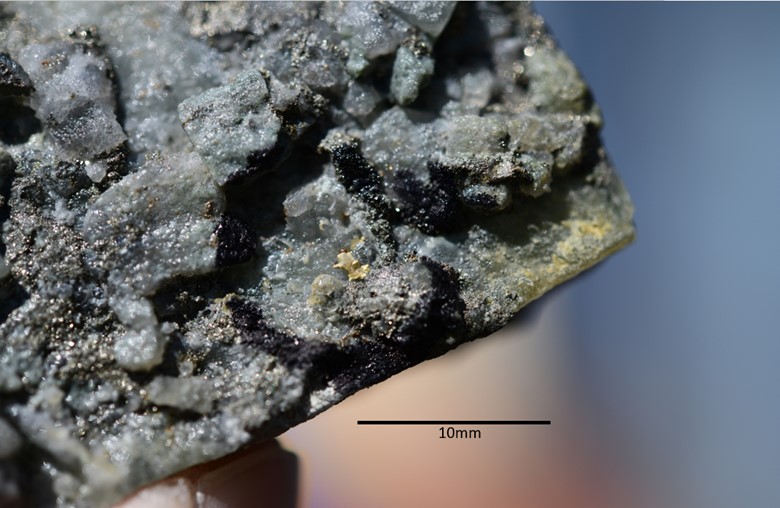
(Figure 1 - Quartz veinlet displaying coarse visible gold.)
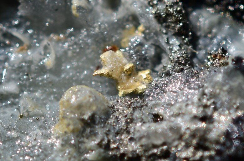
(Figure 2 - Close-up of coarse visible gold particle in Figure 1. Width of picture frame is 7mm.)

(Figure 3 - Plan map showing the outline of the Yamagano Mining Lease (blue, optioned by Irving), the outline of the western part of the East Yamagano claimblock (black), the traces of Yamagano underground mine workings (gray) and the trace of hole 23SY-001 (red).
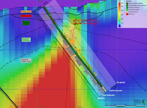
(Figure 4 - Comprehensive cross sectional view of hole 23SY-001 showing gold assay flags. Backdrop is CSAMT resistivity data.)
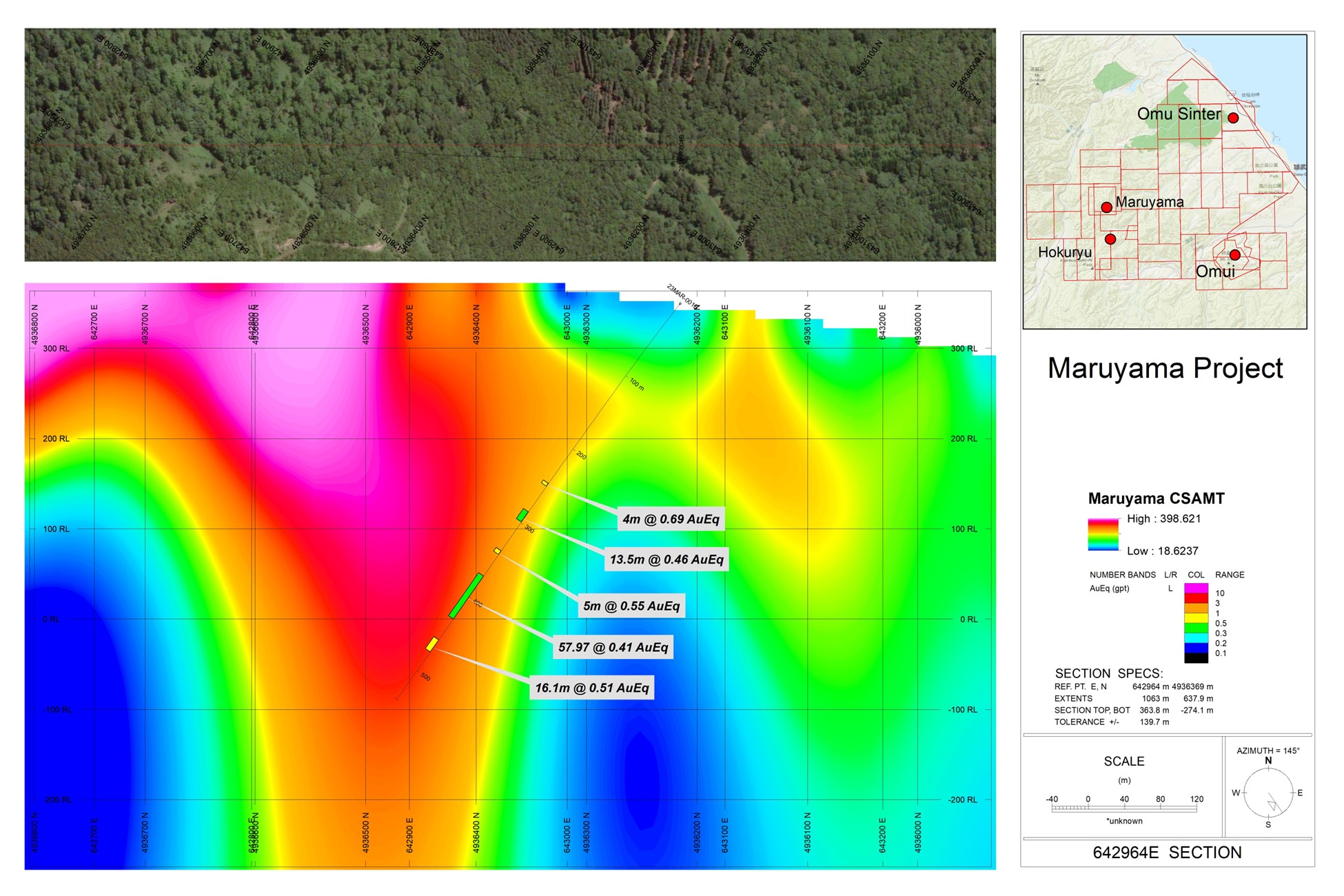
(Figure 5 - Cross sectional view of hole 23MAR-001 showing gold assay flags. Backdrop is CSAMT resistivity data.)
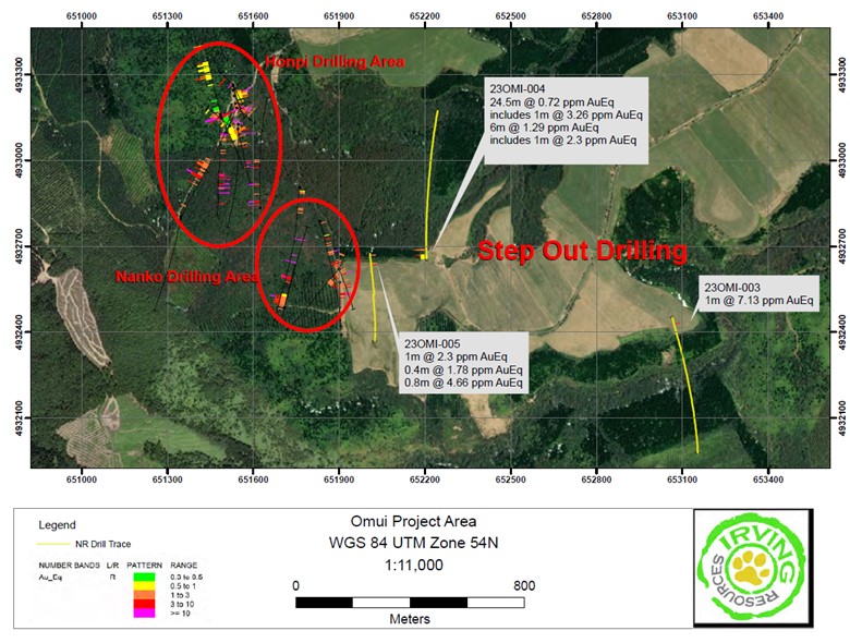
(Figure 6 - Plan view showing the Omui East Extension Target and drill traces for holes 23OMI-003, 23OMI-004 and 23OMI-005 with gold assay flags.)
SOURCE: Irving Resources Inc
View the original press release on accesswire.com