Mammoth Receives Drill Permit for 139 Drill Locations on its Tenoriba Gold Property, Mexico
(TheNewswire)

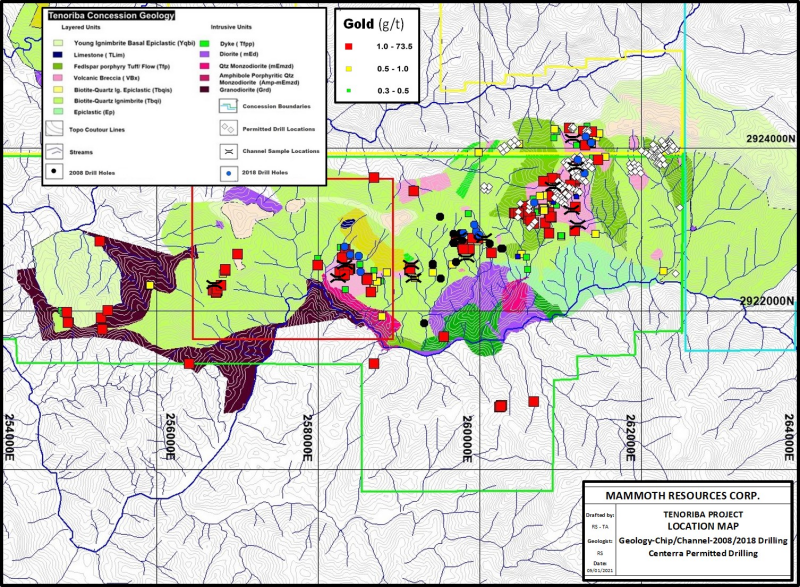
Toronto, Canada – TheNewswire - January 6, 2021 - Mammoth Resources Corp. (TSXV:MTH), (OTC:MMMRF), (the “Company”, or “Mammoth”) is pleased to announce that Mexican environment ministry; Secretaría del Medio Ambiente y Recursos Naturales (SEMARNAT) has approved Centerra’s previously announced drill permit application on Mammoth’s 100% owned Tenoriba gold-silver property located in the prolific Sierra Madre precious metal belt, Mexico. Following this drill permit approval and the recently announced two year surface access agreements (refer to press releases dated November 5, and December 21, 2020), Mammoth has all permissions required to drill up to 139 drill hole locations on the eastern half of the 6 kilometre trend of surface gold-silver mineralization (refer to Figure 1 at the end of this release - “Location Map, Geology-Chip/Channel, 2008/2018 Drilling and Centerra Proposed Drilling” for the location of these 139 drill sites also available on Mammoth’s website, “Projects”, “Maps, Images and Photos”: http://www.mammothresources.ca/s/ProjectImages.asp). Mammoth is required to transfer the Centerra permit approval to itself and this transfer is underway and is expected to imminently be completed.
Thomas Atkins, President and CEO of Mammoth commented on the receipt of this drill permit, stating: “Since the recent announcement two weeks ago wherein Mammoth received surface access approval from the second of two ejidos enabling surface access on the Tenoriba project, Mammoth is now in receipt of the drill permit to drill up to 139 locations at its Tenoriba gold-silver property. All permissions are now in hand to enable Mammoth drilling Tenoriba. We’ll soon begin our in-fill geophysics survey intended to cover most of the 60 percent of the surface mineralized area mapped, sampled and drill tested over as much as 6 kilometres of strike length not covered in Mammoth’s initial geophysics program. Data from this in-fill survey will be integrated into a 3D interpretation of historical geophysical data which will include all surface and drill data and this data will be integrated into the recently completed third-party PhD geologist review of Tenoriba thus providing Mammoth geologists the best picture of the drill target opportunities at Tenoriba. With this combined information Mammoth will target its initial 50-hole drill program expected to commence prior to the end of the first quarter 2021. We feel it’s likely we’ll submit an additional drill permit application to cover drill targets in the western half of the 6 kilometres trend of mineralization, not covered in this permit approval, once we’ve incorporated all the information from this soon to begin surface program.”
Having gained surface access approval in late December from the second of two communities (ejidos) governing surface access at Tenoriba, Mammoth will soon initiate its drill targeting confidence program, including in-fill geophysics and some additional confirmation mapping and sampling. The in-fill IP-Mag geophysics survey is intended to cover most of the 60 percent of the remaining surface mineralized area mapped, sampled and drill tested over an approximate 6 kilometre strike length of mineralization at Tenoriba, not covered in Mammoth’s initial geophysics program. Data from this in-fill survey will be incorporated into the 3D interpretation of the historical IP-Mag survey, currently underway. The combination of geophysics, surface and drill data into the 3D model coupled with observations and recommendations from the recent project review by a third-party PhD geologist, will enable Company geologists to have the best picture of the drill target opportunities along this 6 kilometre strike length from which the first 50 drill holes of a planned extensive drilling program at Tenoriba will be targeted. Mammoth plans to commence this drill program before the end of the first quarter 2021. Once all this information is reviewed and additional drill targets identified, it’s likely Mammoth will apply for an extension of the currently approved drill permit enabling the Company to test additional targets in the western half of the 6 kilometre trend of mineralization at Tenoriba.
Mammoth will announce results from these additional activities once results are available.
About Mammoth Resources:
Mammoth Resources (TSX-V: MTH) is a precious metal mineral
exploration Company focused on acquiring and defining precious metal
resources in Mexico and other attractive mining friendly jurisdictions
in the Americas. The Company holds a 100% interest (subject to a 2%
net smelter royalty purchasable anytime within two years from
commencement of commercial production for US$1.5 million) in the
5,333hectare Tenoriba gold property located in the Sierra Madre
Precious Metal Belt in southwestern Chihuahua State, Mexico. Mammoth
is seeking other opportunities to option exploration projects in the
Americas on properties it deems to host above average potential for
economic concentrations of precious metals mineralization.
To find out more about Mammoth Resources and to sign up to receive future press releases, please visit the company's website at: www.mammothresources.ca., or contact Thomas Atkins, President and CEO at:416 509-4326.
Neither the TSX Venture Exchange nor its Regulation
Services Provider (as that term is defined in the policies of the TSX
Venture Exchange) accepts responsibility for the adequacy or accuracy
of this release.
Forward Looking Information: This news release may contain or refer to forward-looking information. All information other than statements of historical fact that address activities, events or developments that the Company believes, expects or anticipates will or may occur in the future are forward-looking statements; examples include the listing of its shares on a stock exchange and establishing mineral resources. These forward-looking statements are subject to a variety of risks and uncertainties beyond the Company's ability to control or predict that may cause actual events or results to differ materially from those discussed in such forward-looking statements. Any forward-looking statement speaks only as of the date on which it is made and, except as may be required by applicable securities laws, the Company disclaims any intent or obligation to update any forward-looking statement, whether as a result of new information, future events or results or otherwise. Although the Company believes that the assumptions inherent in the forward-looking statements are reasonable, forward-looking statements are not guarantees of future performance and, accordingly, undue reliance should not be placed on these forward-looking statements due to the inherent uncertainty therein.
Figure 1 - Location Map, Geology-Chip/Channel-2008/2018 Drilling and Centerra Proposed Drilling
(permitted drill locations are identified by grey diamonds on the map)
Copyright (c) 2021 TheNewswire - All rights reserved.
