Mandalay Resources Corporation Continues to Deliver Positive Exploration Results at its Costerfield and Bj??rkdal Operations
TORONTO, Jan. 14, 2020 (GLOBE NEWSWIRE) -- Mandalay Resources Corporation ("Mandalay" or the "Company") (TSX: MND, OTCQB: MNDJF) is pleased to report continuing positive results from the exploration programs at its Costerfield operation in Victoria, Australia, and at its Björkdal operation in Skellefteå, Sweden. This press release discloses diamond drilling results completed since the Company’s previous exploration release on September 30, 2019. Figures illustrating the results can be found at the end of this press release.
Highlights
Costerfield
- New close spaced drilling has increased confidence in the upper section of the Youle vein, where mining is underway;
- Step out drilling on the Youle vein and at the historic Costerfield mine to the north has discovered mineralized extensions (see Figures 1 to 6 and Tables 1 to 3 below); and
- The first parent and wedge daughter holes on the Costerfield Deeps target have been completed beneath the Youle orebody. Structural knowledge and multielement geochemistry from these holes have been used to target a second parent hole testing the Deeps target under the August Deposits. Drilling of the second program will commence later in 2020.
Björkdal
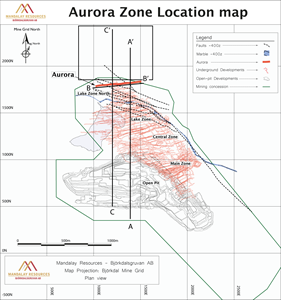
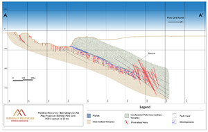
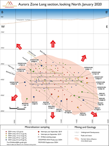
- Extensional drilling at the Aurora zone continues to enlarge the structurally controlled, high-grade mineralization, which trends at depth towards the east (see Figures 7 to 10 and Tables 4 to 7 below);
- Drilling of high-grade targets, including skarn mineralization near underground infrastructure, have improved mine planning to deliver sustainable high head grades from the mine; and
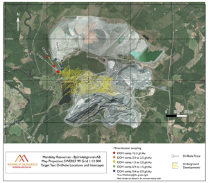
- Target testing holes have confirmed the continuation of mineralization in new veins up to 500 metres (“m”) northward from the presently defined Aurora zone.
Dominic Duffy, President and Chief Executive Officer of Mandalay, commented, “We are pleased to report continued exploration success at both of our sites. The most recent drilling results at Costerfield and Björkdal confirm the significant upside potential value of our operations.”
Mr. Duffy added, “At Costerfield, optimization drilling within the upper part of the Youle vein has confirmed the high-grade resources previously published for the vein and filled in previous wide-spaced intercepts along a strike of 450 m. These results will support improved planning and execution of mining operations and longer life of the Youle vein.”
Mr. Duffy continued, “We have now concluded the daughter hole wedged off the first Costerfield Deeps hole CD001. The results have advanced our geological understanding of this highly prospective area. This has provided the information for planning the second deep parent and daughter holes to target under the Augusta system, which will be drilled in 2020.”
Mr. Duffy concluded, “At Björkdal, drilling to extend orebodies currently being mined has allowed us to bring higher head grade into the mine plan. Both the Aurora zone and skarn mineralization have been significantly extended. Meanwhile, target testing as much as 500 m north of the Aurora zone has intersected new gold bearing veins.”
Mandalay Drilling Programs
Costerfield Drilling Programs
Mandalay continues the three exploration programs at Costerfield that were commenced in May 2019.
Youle Optimization Drilling
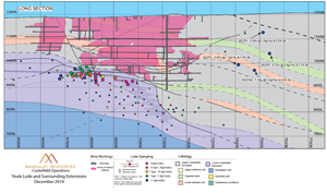
Since the Company’s last exploration press release on September 30, 2019, Mandalay has continued to develop and optimize extraction of the high-grade Youle vein. The resulting geological interpretation and assay results are expected to enlarge the upper portion of the Youle deposit in which mining is currently underway. Furthermore, this drilling has identified a series of sheeted stibnite veins extending up to 10 m into the west wall of the main lode within the upper sections of the mine. Due to the angle of earlier surface drilling, the extent of this veining was not realized until underground drilling occurred.
Five active headings are presently being mined within the upper 40 m of the Youle vein.
Recent results (Tables 1 and 2) from the optimization drilling has identified significant zones of mineralization; coarse, nugget gold occurs in many of the samples. For example, hole KD583 contains a visible gold (“Au”) and stibnite within a quartz matrix (Figure 1). This intercept returned grades of 4,000 g/t Au and 1.5 % antimony (“Sb”) over a width of 0.04 m. Other results include KD603 in which 303.0 g/t Au and 52.1% Sb occur over a width of 0.37 m.
Table 1: Youle Optimization Drilling Highlights
| Hole ID | True Width (m) | Au Grade (g/t) | Sb Grade (%) | AuEq (g/t) over min. 1.8m mining width |
| KD583 | 2.12 | 85.3 | 6.5 | 96.3 |
| KD596 | 1.18 | 159.2 | 38.3 | 146.8 |
| KD602 | 0.43 | 167.0 | 47.2 | 59.3 |
| KD603 | 0.37 | 303.0 | 52.1 | 79.8 |
Figure 1: Youle intercept within KD583 displaying gold and stibnite within a matrix of quartz
https://www.globenewswire.com/NewsRoom/AttachmentNg/21be06be-ae7e-47c7-b29d-172eeeeccdba
Table 2: Youle Optimization Drilling Results (September 2019 – December 2019)
| Hole ID | Hole Completion Date | Total hole Depth | Intercept Easting (Mine Grid) | Intercept Northing (Mine Grid) | Intercept Elevation (Mine Grid) | Drilled Width (m) | True Width (m) | Au Grade (g/t) | Sb Grade (%) | AuEq (g/t) over min. 1.8m mining width | Sampled Structure |
| KD529 | 26/07/2019 | 82.8 | 15414 | 6771 | 966 | 2.58 | 2.42 | 0.8 | 2.5 | 5.0 | Youle + Splays |
| Including | 0.21 | 0.20 | 50.0 | 48.3 | 14.4 | Youle | |||||
| KD530 | 28/07/2019 | 81.0 | 15414 | 6742 | 978 | 0.15 | 0.13 | 2.7 | 6.3 | 1.0 | Youle |
| KD552 | 6/09/2019 | 49.8 | 15400 | 6768 | 957 | 0.27 | 0.17 | 128.0 | 56.6 | 21.3 | Youle |
| KD553 | 9/09/2019 | 44.3 | 15415 | 6771 | 974 | 0.10 | 1.81 | 2.1 | 2.0 | 5.5 | Youle |
| KD554 | 18/09/2019 | 39.4 | 15394 | 6764 | 948 | 0.27 | 0.24 | 38.9 | 35.1 | 13.4 | Youle |
| KD555 | 3/10/2019 | 35.2 | 15389 | 6781 | 941 | 0.41 | 0.35 | 0.2 | 0.3 | 0.1 | Youle |
| KD556 | 26/09/2019 | 70.0 | 15413 | 6792 | 957 | 0.29 | 0.25 | 24.8 | 17.1 | 7.5 | Youle |
| KD557 | 23/09/2019 | 82.0 | 15417 | 6799 | 969 | 0.43 | 0.33 | 6.2 | 3.8 | 2.3 | Youle |
| KD558 | 1/10/2019 | 59.0 | 15411 | 6804 | 967 | 0.08 | 35.6 | 19.7 | 3.0 | Youle | |
| KD559 | 20/11/2019 | 33.0 | 15394 | 6804 | 949 | 2.16 | 1.61 | 4.8 | 4.9 | 11.8 | Youle |
| KD560 | 3/10/2019 | 75.0 | 15397 | 6726 | 961 | 0.17 | 0.13 | 25.6 | 0.2 | 1.9 | Youle |
| KD561 | 14/10/2019 | 50.0 | 15390 | 6731 | 955 | 0.95 | 0.82 | 5.3 | 4.2 | 5.7 | Youle |
| KD562 | 15/10/2019 | 39.3 | 15388 | 6733 | 947 | 0.42 | 0.38 | 33.6 | 22.5 | 15.0 | Youle |
| KD563 | 17/10/2019 | 40.0 | 15393 | 6748 | 949 | 0.85 | 0.82 | 3.5 | 4.7 | 5.2 | Youle |
| KD571 | 5/11/2019 | 125.0 | 15371 | 6682 | 960 | 0.23 | 0.15 | 9.0 | 3.5 | 1.3 | Youle |
| KD572 | 1/11/2019 | 105.2 | 15373 | 6683 | 949 | 0.76 | 0.65 | 0.1 | 0.9 | 0.6 | Youle |
| KD573 | 27/12/2019 | 85.7 | 15352 | 6679 | 936 | 0.21 | 0.20 | 0.7 | 5.4 | 1.1 | Youle |
| KD574 | 22/10/2019 | 70.0 | 15440 | 6757 | 985 | 6.75 | 5.53 | 1.4 | 1.1 | 3.3 | Youle + Splays |
| Including | 0.13 | 0.10 | 47.2 | 25.2 | 4.9 | Youle | |||||
| KD576 | 23/10/2019 | 90.5 | 15420 | 6789 | 984 | 0.16 | 0.10 | 20.1 | 10.4 | 2.1 | Youle |
| KD576 | 23/10/2019 | 90.5 | 15432 | 6800 | 988 | 1.00 | 0.62 | 12.9 | 1.1 | 5.0 | Splay Vein |
| KD580 | 25/10/2019 | 35.0 | 15414 | 6802 | 958 | 0.27 | 0.20 | 65.5 | 21.3 | 11.2 | Youle |
| KD580 | 25/10/2019 | 35.0 | 15407 | 6799 | 955 | 0.61 | 0.45 | 0.9 | 3.1 | 1.6 | Splay Vein |
| KD580 | 25/10/2019 | 35.0 | 15413 | 6801 | 958 | 0.44 | 0.32 | 2.2 | 9.2 | 3.2 | Splay Vein |
| KD583 | 11/11/2019 | 90.3 | 15403 | 6825 | 956 | 3.11 | 2.12 | 85.3 | 6.5 | 96.3 | Youle |
| Including | 0.07 | 0.04 | 4000.0 | 0.5 | 98.5 | Youle | |||||
| KD584 | 13/11/2019 | 72.0 | 15399 | 6826 | 947 | 0.83 | 0.77 | 6.1 | 5.8 | 6.8 | Youle |
| KD585 | 14/11/2019 | 56.0 | 15391 | 6826 | 938 | 3.96 | 3.72 | 20.0 | 10.8 | 38.3 | Youle |
| Including | 0.33 | 0.31 | 194.0 | 55.9 | 49.8 | Youle | |||||
| KD586 | 15/11/2019 | 45.0 | 15382 | 6827 | 930 | 1.04 | 0.98 | 0.2 | 0.0 | 0.1 | Youle |
| KD587 | 18/11/2019 | 45.0 | 15373 | 6828 | 921 | 0.58 | 0.49 | 50.7 | 14.5 | 20.3 | Youle |
| KD588 | 8/11/2019 | 34.9 | 15404 | 6728 | 973 | 0.14 | 0.12 | 2.6 | 12.2 | 1.6 | Splay Vein |
| KD588 | 8/11/2019 | 34.9 | 15407 | 6724 | 974 | 0.21 | 0.18 | 32.1 | 12.3 | 5.4 | Youle |
| KD589 | 13/11/2019 | 54.5 | 15413 | 6953 | 924 | 1.00 | 0.95 | 55.2 | 34.8 | 60.3 | Youle |
| KD593B | 27/11/2019 | 90.0 | 15412 | 6841 | 956 | 1.15 | 0.83 | 30.3 | 9.6 | 21.5 | Youle |
| KD593B | 27/11/2019 | 90.0 | 15408 | 6840 | 956 | 0.46 | 0.44 | 3.7 | 6.1 | 3.4 | Splay Vein |
| KD594 | 25/11/2019 | 90.0 | 15405 | 6857 | 954 | 1.82 | 1.33 | 1.9 | 1.8 | 3.7 | Splay Vein |
| KD595 | 28/12/2019 | 82.0 | 15403 | 6856 | 945 | 7.25 | 4.16 | 3.8 | 3.6 | 9.9 | Youle |
| Including | 0.90 | 0.52 | 14.1 | 8.7 | 8.3 | Youle | |||||
| And Including | 0.71 | 0.41 | 14.5 | 6.8 | 5.9 | Youle | |||||
| KD596 | 24/11/2019 | 70.0 | 15394 | 6856 | 932 | 1.69 | 1.18 | 159.2 | 38.3 | 146.8 | Youle |
| KD598 | 20/11/2019 | 68.3 | 15409 | 6908 | 940 | 7.29 | 6.18 | 3.0 | 3.5 | 8.9 | Youle |
| Including | 0.30 | 0.23 | 59.6 | 42.0 | 17.1 | Youle | |||||
| KD602 | 5/12/2019 | 67.0 | 15417 | 6978 | 926 | 0.48 | 0.43 | 167.0 | 47.2 | 59.3 | Youle |
| KD603 | 5/12/2019 | 55.0 | 15412 | 6959 | 913 | 0.38 | 0.37 | 303.0 | 52.1 | 79.8 | Youle |
Youle Northern Extension Drilling Program
The Youle Extension program is ongoing. The goals are to delineate a complex high-grade zone to the north while expanding on the success of the program as reported in September 2019 and extending mineralization further to the north.
The drilling program continues to increase the Company’s understanding of the gold and antimony concentration, expanding the mineralization a further 600 m to the north. Confirmation of the structural continuity of the favorable mineralized vein sets currently being mined in Youle has been identified in the northern drilling. These mineralized west dipping vein sets will become the focus of exploration drilling in January 2020.
Exploration has continued on the Youle northern extension program, with four diamond holes completed since the September 2019 press release, totaling 1,569 m.
The northern-most hole, BC079 targeted the array of veins that make up the northern component of Youle, with anomalous values of up to 0.86 g/t Au and 2.13% Sb over 0.12 m. This result confirms that quartz-stibnite-gold mineralization persists to the north, the mineralized veins being analogous to currently mined structures in the Youle lode. Drilling is currently underway targeting Youle down plunge to the north at the intersection of the No.4 fault.
Further interpretation and modelling of a gold and antimony bearing laminated quartz vein intercepted in drill hole BC075 in September 2019 (0.42 m @ 7.2 g/t Au and 4.4% Sb), has generated a highly prospective target 400 m to the north of current mining operations on Youle. This west dipping vein has been recognized to be in the same orientation as the most productive lode structures at Youle and Augusta. Drill hole planning is currently underway to test this prospective structure.
Table 3: Youle Northern Drilling Results (September 2019 – December 2019)
| Hole ID | Hole Completion Date | Total hole Depth | Intercept Easting (Mine Grid) | Intercept Northing (Mine Grid) | Intercept Elevation (Mine Grid) | Drilled Width (m) | True Width (m) | Au Grade (g/t) | Sb Grade (%) | AuEq (g/t) over min. 1.8m mining width |
| BC076 | 9/09/2019 | 176.1 | No intercept - hole aborted | |||||||
| BC077 | 25/10/2019 | 437.5 | 15537 | 7425 | 994 | 1.16 | 0.51 | 0.6 | 1.5 | 0.61 |
| BC078 | 10/10/2019 | 536.2 | 15565 | 7465 | 971 | 1.96 | 1.73 | 0.4 | 0.0 | 0.37 |
| BC079 | 31/10/2019 | 419.6 | 15510 | 7542 | 1126 | 0.14 | 0.12 | 0.9 | 2.1 | 0.2 |
Costerfield Deeps Drilling Program
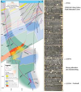
The wedge hole from CD001 has been completed and extensively sampled. CD001W1 reached a final depth of 1,197 m after passing through the large thrust observed in the parent hole CD001. This thrust fault is, believed to be the King Cobra Fault footwall contact intercepted at 1,023 m downhole (Figure 4). The same bleached wall rock alteration halo with minor sulphides identified in CD001 (coincident with elevated gold, antimony and arsenic assays) was found in the wedge from approximately 950 m downhole. Of interest is a zone of intense bleaching and stockwork veining between 1,007 – 1,023 m (Figure 4) which may indicate of a more focused mineralizing fluid system than seen in CD001.
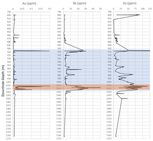
Trace element geochemical analysis was undertaken on lithology and observed alteration of interest including the entire altered and stockworked zone around the interpreted King Cobra Fault. The data shows elevated gold, antimony and arsenic through the target zone supporting and extending the results from the parent drill hole (Figure 5).
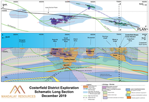
Previous deep drilling has identified high gold grade enrichments underneath the depleted Cuffley deposit, that were hosted within the same stratigraphic sequence targeted by CD001W1, within an anticlinal setting. The Company believes that this environment may, as it does in the south, host significant gold enrichment. These targeted carbonaceous units were identified to be in a truncated state, cut by a series of west-dipping faults with a considerable amount of strike-slip movement. Although clearly elevated in gold and antimony the targeted fluid trap environment was not realized which suggests that the fault system is likely to have acted as a conduit for ore-forming fluids ascending to the Youle deposit. The clearly hydrothermally active setting it still a highly prospective target as demonstrated by the grades previously drilled in CSK007 and CSK012 (Figure 6).
Detailed structural logging though the 2019 deeps drilling has been integrated into the regional prospectively model and, along with underground mapping, drilling and surface mapping, a clear picture of highly prospective envelopes is being uncovered at depth along the 5 kilometre (“km”) mineral field. These targets are the focus of our continuing efforts and drill planning.
Björkdal Drilling Programs
Aurora Drilling Program
Underground drilling has focused on extending the existing Aurora zone. Results to date have revealed the presence of a structurally controlled, high-grade zone, trending at depth towards the east. The up-dip extension of the horizon will be investigated from surface in Q1 2020. The zone is currently being mined on five active levels.
Northern Target Test Drilling
Underground drilling focused on investigating the continuation of the mineralized body towards the north of the current operations. A total of four holes were completed, however, due to bad ground conditions and the ingress of abundant water only three of the four holes reached total depth. The holes intercepted interbedded Dacite, Andesite and Basalt, typical of Björkdal with a number of brittle faults and shears. Results to date confirm the continuation of mineralization up to 500 m away from the current mine workings. A follow up drill campaign will commence in Q1 2020 in order to confirm the intercepts from 2019.
Björkdal Drilling Results
Björkdal Drilling Results
Since the Company’s last exploration press release on September 30, 2019, the Company has assayed 27 drill holes in the Aurora zone at Björkdal (see Table 6) and 4 target test drill holes to the north of the current mining operations (see Table 7). Recent highlights from the Aurora and northern target test drilling assays include the following intercepts:
Table 4: Aurora drilling Highlights
| Hole ID | True Width | Au g/t |
| DOD2019-096 | 6.78 | 2.43 |
| DOD2019-097 | 3.85 | 3.57 |
| MU9-024 | 8.05 | 2.39 |
| MU9-026 | 10.73 | 3.85 |
| MU9-028A | 4.83 | 2.11 |
| MU9-029 | 3.78 | 14.78 |
Table 5: Northern target test drilling Highlights
| Hole ID | True Width | Au g/t |
| MU9-015 | 0.40 | 60.00 |
| MU9-015 | 0.34 | 26.20 |
| MU9-016 | 0.45 | 26.00 |
| MU9-016 | 0.27 | 33.50 |
| MU9-016 | 0.40 | 10.50 |
| MU9-016 | 0.75 | 27.65 |
Table 6: Aurora Drilling Results (September 2019 – January 2020)
| Hole Id | Hole Completion Date | Intercept Northing (Mine Grid) | Intercept Easting (Mine Grid) | Intercept Elevation (Mine Grid) | From (m) | To (m) | Drilled Width (m) | True Width (m) | Au (g/t) | Au (g/t) over min. 3 m mining width |
| DOD2019-053 | 9/07/2019 | 1745 | 1147 | -382 | 109.75 | 113.70 | 3.95 | 3.87 | 1.43 | 1.43 |
| DOD2019-055 | 8/08/2019 | 1743 | 1165 | -392 | 101.90 | 106.25 | 4.35 | 4.34 | 1.42 | 1.42 |
| DOD2019-063 | 4/09/2019 | 1730 | 1217 | -356 | 68.00 | 73.00 | 5.00 | 4.96 | 0.51 | 0.51 |
| DOD2019-092 | 1/09/2019 | 1775 | 1109 | -461 | 139.00 | 142.73 | 3.73 | 2.96 | 0.58 | 0.58 |
| DOD2019-093 | 7/10/2019 | 1797 | 1452 | -433 | 73.60 | 77.00 | 3.40 | 3.35 | 1.72 | 1.72 |
| DOD2019-094 | 10/10/2019 | 1810 | 1472 | -454 | 80.40 | 83.70 | 3.30 | 3.20 | 1.05 | 1.05 |
| DOD2019-095 | 12/10/2019 | 1808 | 1478 | -428 | 84.30 | 89.80 | 5.50 | 5.41 | 1.59 | 1.59 |
| DOD2019-096 | 22/10/2019 | 1814 | 1509 | -465 | 91.00 | 99.12 | 8.12 | 6.78 | 2.43 | 2.43 |
| DOD2019-097 | 26/10/2019 | 1800 | 1508 | -435 | 85.00 | 89.40 | 4.40 | 3.85 | 3.57 | 3.57 |
| MU9-021 | 26/08/2019 | 1869 | 1485 | -575 | 174.20 | 187.45 | 13.25 | 6.37 | 0.51 | 0.51 |
| MU9-022 | 16/09/2019 | 1843 | 1474 | -525 | 124.80 | 136.80 | 12.00 | 7.34 | 1.15 | 1.15 |
| MU9-023 | 30/08/2019 | 1858 | 1458 | -557 | 153.45 | 166.10 | 12.65 | 8.90 | 1.09 | 1.09 |
| MU9-024 | 9/09/2019 | 1896 | 1450 | -622 | 224.00 | 236.10 | 12.10 | 8.05 | 2.39 | 2.39 |
| MU9-025 | 22/09/2019 | 1847 | 1426 | -546 | 140.65 | 147.60 | 6.95 | 2.99 | 0.93 | 0.93 |
| MU9-026 | 27/09/2019 | 1870 | 1380 | -570 | 160.30 | 176.10 | 15.80 | 10.73 | 3.85 | 3.85 |
| MU9-027 | 2/10/2019 | 1875 | 1344 | -581 | 179.65 | 189.35 | 9.70 | 5.51 | 0.71 | 0.71 |
| MU9-028A | 9/10/2019 | 1858 | 1325 | -553 | 156.60 | 163.50 | 6.90 | 4.83 | 2.11 | 2.11 |
| MU9-029 | 31/10/2019 | 1847 | 1282 | -538 | 142.10 | 146.55 | 4.45 | 3.78 | 14.78 | 14.78 |
| MU9-032 | 23/10/2019 | 1852 | 1162 | -557 | 182.20 | 183.40 | 1.20 | 0.50 | 2.54 | 0.42 |
| MU9-033A | 17/10/2019 | 1855 | 1120 | -571 | 179.20 | 181.60 | 2.40 | 1.15 | 3.33 | 1.28 |
Table 7: Northern Target Test Drilling Results (September 2019 – January 2020)
| Hole Id | Hole Completion Date | Intercept Northing (Mine Grid) | Intercept Easting (Mine Grid) | Intercept Elevation (Mine Grid) | From (m) | To (m) | Drilled Width (m) | True Width (m) | Au (g/t) | Au (g/t) over min. 3 m mining width |
| MU9-015 | 23/09/2019 | 1830 | 1161 | -436 | 1.65 | 2.10 | 0.45 | 0.40 | 60.00 | 8.00 |
| MU9-015 | 1845 | 1156 | -443 | 18.70 | 19.25 | 0.55 | 0.34 | 26.20 | 2.97 | |
| MU9-016 | 12/10/2019 | 1830 | 1161 | -437 | 2.60 | 3.10 | 0.50 | 0.45 | 26.00 | 3.90 |
| MU9-016 | 2011 | 1158 | -526 | 203.60 | 204.00 | 0.40 | 0.27 | 33.50 | 3.02 | |
| MU9-016 | 2260 | 1164 | -635 | 476.40 | 476.90 | 0.50 | 0.40 | 10.50 | 1.40 | |
| MU9-016 | 2283 | 1165 | -644 | 500.35 | 501.25 | 0.90 | 0.75 | 27.65 | 6.91 | |
| MU9-017 | 29/10/2019 | 1828 | 1265 | -436 | 12.85 | 13.75 | 0.90 | 0.59 | 4.84 | 0.95 |
| MU9-017 | 1837 | 1265 | -440 | 21.50 | 23.30 | 1.80 | 1.11 | 1.31 | 0.48 | |
| MU9-017 | 1857 | 1265 | -447 | 44.10 | 44.90 | 0.80 | 0.57 | 2.59 | 0.49 | |
| MU9-017 | 1879 | 1265 | -455 | 67.20 | 68.20 | 1.00 | 0.92 | 2.87 | 0.88 | |
| MU9-017 | 1985 | 1266 | -489 | 178.30 | 178.75 | 0.45 | 0.40 | 3.24 | 0.43 | |
| MU9-017 | 2114 | 1271 | -526 | 313.25 | 313.90 | 0.65 | 0.53 | 2.81 | 0.50 | |
| MU9-018 | 18/11/2019 | 1937 | 1227 | -497 | 143.40 | 143.85 | 0.45 | 0.21 | 5.72 | 0.40 |
Figure 2: Inset of the Costerfield Longitudinal Section Illustrating the New Production Optimization Drilling (POD) Results Along with Location of On Vein Development
https://www.globenewswire.com/NewsRoom/AttachmentNg/8d55bd4e-b3b6-4cb5-9b24-f177b359ae78
Figure 3: Longitudinal Section and Plan Section of Youle (Costerfield) Illustrating Location of Recent Intercepts with Detail along the Northern Extension Drilling
https://www.globenewswire.com/NewsRoom/AttachmentNg/a839bd80-2096-442a-a746-0ba7f2a479a6
https://www.globenewswire.com/NewsRoom/AttachmentNg/d39e8cc0-a129-456d-b957-75eaf762da7f
Figure 4: Cross Section of Costerfield Deeps Drill Holes CD001 and CD001W1 with Interpreted Geology, Displaying Relationship to Youle and the Costerfield mine
https://www.globenewswire.com/NewsRoom/AttachmentNg/c597cfee-3b86-475b-8dba-359b03def61d
Figure 5: Downhole trace-level geochemistry of CD001W1, showing correlation of elevated Gold Antimony and Arsenic through Target Zone (Blue band) with constant elevation immediately around and within the King Cobra Fault (Orange band).
https://www.globenewswire.com/NewsRoom/AttachmentNg/384af91f-8b4e-4ed5-b72f-a8d46161b2db
Figure 6: Schematic Regional Long Section of the Costerfield District, Showing the Position of the Costerfield Deeps Drill Hole Cross Section at 6900N (B-B’)
https://www.globenewswire.com/NewsRoom/AttachmentNg/989b9603-eee8-45ba-a458-243049fb491a
Figure 7: Björkdal Mine Scale Overview Map Showing the Location of the Aurora Zone and the Northern target test drilling in relation to mine development
https://www.globenewswire.com/NewsRoom/AttachmentNg/274b65c6-b3a9-4532-835f-766a65cf36ce
Figure 8: Cross sections of Björkdal Mine Area Showing the Location and Current Size of the Aurora Zone (A-A’) and the Northern Target Test Program (C-C’).
https://www.globenewswire.com/NewsRoom/AttachmentNg/df50e044-1f3b-4161-889e-28e2c390c5ea
https://www.globenewswire.com/NewsRoom/AttachmentNg/c2ebb93a-8b70-473d-b6bb-a795c20b472b
Figure 9: Longitudinal Section of the Aurora Zone Illustrating Location of Recent Intercepts
https://www.globenewswire.com/NewsRoom/AttachmentNg/6382124d-f235-45e2-b5f8-a3bd4f0d0fea
Figure 10: Overview map of Björkdalsgruvan showing the location of the target test drilling in relation to mine development.
https://www.globenewswire.com/NewsRoom/AttachmentNg/1caa3a0a-43e5-4664-a91d-dc51a53750f1
Drilling and Assaying
At Costerfield, diamond drill core was logged and sampled by Costerfield geologists. All samples were sent to OnSite Laboratory Services in Bendigo, Victoria, Australia, for sample preparation and assay. Site geological and metallurgical personnel have implemented a QA/QC process that includes the regular submission of standard reference materials and blanks with drill and face samples submitted for assay. Standard reference materials have been certified by Geostats Pty Ltd. (February 6, 2019 Technical Report entitled “Costerfield Operation, Victoria, Australia NI 43-101 Report”, available on SEDAR (www.sedar.com), which contains a complete description of drilling, sampling, and assaying procedures).
At Björkdal, all diamond drill core was logged and sampled by Björkdal geologists. Exploration drill hole samples (prefix MU) were sent to CRS Minlab Oy (CRS) in Kempele, Finland for sample preparation and assaying. Development Optimization drill hole samples (prefix DOD) were at the onsite lab ran by ALS for sample preparation and assaying (see March 28, 2019, Technical Report entitled “Technical Report on the Björkdal Gold Mine, Sweden”, available on SEDAR (www.sedar.com), which contains a complete description of drilling, sampling, and assaying procedures).
Assaying in both the CRS and ALS laboratories was conducted utilizing the Pal1000 (CRS) cyanide leaching processes. Mandalay’s rigorous QA/QC program included the use of standard reference samples, blanks, duplicates, repeats, and internal laboratory quality assurance procedures.
Qualified Person:
Chris Gregory, Vice President of Operational Geology and Exploration at Mandalay Resources, is a Member of the Australian Institute of Geoscientists (AIG), and a Qualified Person as defined by NI 43-101. He has reviewed and approved the technical and scientific information provided in this release.
For Further Information
Dominic Duffy
President and Chief Executive Officer
Edison Nguyen
Manager, Analytics and Investor Relations
Contact:
647.260.1566
About Mandalay Resources Corporation
Mandalay Resources is a Canadian-based natural resource company with producing assets in Australia and Sweden, and care and maintenance and development projects in Chile. The Company is focused on growing production at its gold and antimony operation in Australia, and gold production from its operation in Sweden to generate near term cash flow.
Forward-Looking Statements:
This news release contains "forward-looking statements" within the meaning of applicable securities laws, including statements regarding the exploration and development potential of the Youle deposit (Costerfield) and the Aurora Zone (Björkdal). Readers are cautioned not to place undue reliance on forward-looking statements. Actual results and developments may differ materially from those contemplated by these statements depending on, among other things, changes in commodity prices and general market and economic conditions. The factors identified above are not intended to represent a complete list of the factors that could affect Mandalay. A description of additional risks that could result in actual results and developments differing from those contemplated by forward-looking statements in this news release can be found under the heading “Risk Factors” in Mandalay’s annual information form dated March 28, 2019, a copy of which is available under Mandalay’s profile at www.sedar.com. In addition, there can be no assurance that any inferred resources that are discovered as a result of additional drilling will ever be upgraded to proven or probable reserves. Although Mandalay has attempted to identify important factors that could cause actual actions, events or results to differ materially from those described in forward-looking statements, there may be other factors that cause actions, events or results not to be as anticipated, estimated or intended. There can be no assurance that forward-looking statements will prove to be accurate, as actual results and future events could differ materially from those anticipated in such statements. Accordingly, readers should not place undue reliance on forward-looking statements.


