Marimaca's Roble Target Continues to Show Significant Potential
VANCOUVER, British Columbia, July 01, 2021 (GLOBE NEWSWIRE) -- Marimaca Copper Corp. (“Marimaca Copper” or the “Company”) (TSX: MARI) is pleased to provide an update on the ongoing exploration work being completed, ahead of drilling, at the Roble Target (“Roble”). Roble is located less than 3km to the northeast of the Company’s flagship Marimaca Oxide Deposit (“MOD”), and mineralization may extend over 3km of potential strike. The commencement of drilling at Roble has been delayed primarily because the Company elected to expand the drilling program at the Mercedes Target based on encouraging mineralization observed in drilling, but also due to some delays caused by COVID restrictions.
Highlights
- Additional rock chip reconnaissance sampling at Roble has materially expanded the footprint of outcropping oxide mineralization
- Mapped outcrop extends further north at Roble and south and east at Pele
- Extends strike potential to over 3km with widths at surface ranging from 300m to over 500m
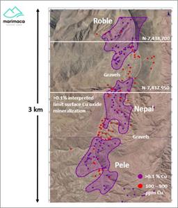
- Three discrete areas of consistently outcropping mineralization, each extending over approximately 600m by 400m, separated by gravel and sand cover
- Potential for connection of the larger Roble system through these covered areas
- Geophysics identified the continuation at depth of significant regional structures which control the location of mineralization in the Marimaca district
- Interpreted structures are strongly coincident with surface trends of outcropping Cu oxide mineralization with greater than 0.1% CuT
- Drilling to commence imminently at Roble with an initial twelve-hole reverse circulation (RC) discovery drilling program
- The Company has expanded the RC drilling campaign at Mercedes from nine holes to eighteen holes due to encouraging mineralization intersected
- Resultant delay to the commencement of drilling at Roble, which is now expected during July
- Additional rigs planned for 2H 2021 based on expanded exploration programs at Marimaca Depth Extensions, Cindy, Mercedes and Roble
Sergio Rivera, VP Exploration of Marimaca Copper, commented:
“We have expanded our reconnaissance work at Roble which continues to indicate a potentially significant mineralized system, with outcropping mineralization now extending over quite a broad 3km corridor of strike. It is highly unusual to identify an undrilled target, with extensive outcropping mineralization, in a mature copper jurisdiction like Chile.
“We have also completed Induced Polarization (IP) surveys to complement the magnetics, surface reconnaissance and sampling work. This shows, quite clearly, the extensive north trending structural controls of the Roble Fault System are identifiable at depth. Notably, the resistivity anomaly is strongly coincident with the northern trend identified in the surface sampling work, highlighting a broad area of greater than 0.1% CuT coincident with the Roble Fault System and the magnetic anomaly identified in previous surveys. For IOCG deposits, large-scale structures controlling mineralization are essential for forming more extensive systems, and we believe the indications are Roble could be a significant system.
“We have been delayed slightly in commencing our drilling campaign at Roble, but we are currently finalizing our planning and infrastructure construction and expect to be drilling Roble during July.”
Overview of Exploration Results
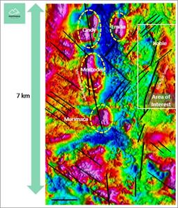
Roble is located less than 3km to the northeast of the Company’s flagship Marimaca Oxide Deposit (“MOD”), within the north-north-east trending Roble Fault System. This is a splay off the regional scale Naguayán Fault System, which is an important control for mineralization at the MOD.
Figure 1: Map with New Targets for Exploration Defined by Magnetic Survey Relative to Marimaca Oxide Deposit
https://www.globenewswire.com/NewsRoom/AttachmentNg/e48c104e-c2c0-4fd0-9278-7f9685e7997c
Roble is associated with a large magnetic anomaly previously identified in the regional, high-resolution, drone mounted magnetics survey (refer to announcement on 23 September 2020). The Company has subsequently completed surface exploration work including rock grid geochemical sampling, reconnaissance mapping and outcrop sampling which defined a large copper-in-rock anomaly and also highlighted the significant extent of outcropping copper oxide mineralization at the surface (refer to announcement on 22 April 2021).
The initial exploration work and subsequent reconnaissance mapping and sampling of outcropping oxide mineralization has defined three distinct zones, each extending approximately 600m along strike by 400m across strike. These zones are separated by post mineralization gravels and sands and the Company believes there is the potential for them to be connected under the areas of cover.
Figure 2: Map Showing Three Discrete Areas with Interpreted Limits of Outcropping Cu Oxide Mineralization > 0.1% CuT on IP-R Survey Lines
https://www.globenewswire.com/NewsRoom/AttachmentNg/42ff55e1-2867-4a89-8cc5-86192ffdafa6
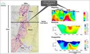
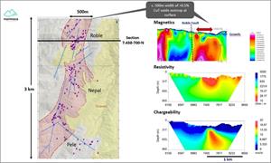
Following the success of the initial surface exploration work, the Company engaged GRS Geophysics to complete two 2.5km Induced Polarization (“IP”) surveys (AMT-MIMDAS) for a total of 5km of survey, with one line located in the central area, the other approximately 750m to the north, on the northern part of the area of interest.
Both lines show attractive coincident resistivity and chargeability anomalies associated with the high magnetic response and clearly highlights the regional scale of Roble Fault System, which the Company believes could be important for controlling copper mineralization in the area. Furthermore, the geophysical anomalies (both magnetic and IP) appear to be strongly coincident with the outcropping copper mineralization mapped in the reconnaissance work, both of which follow the broader northerly trend of the Roble Fault System.
Figure 3: IP and Magnetic Section 7.437.950-N
https://www.globenewswire.com/NewsRoom/AttachmentNg/f3c4c684-f187-4f68-b4aa-043c62d75e8c
Figure 3: IP and Magnetic Section 7.438.700-N
https://www.globenewswire.com/NewsRoom/AttachmentNg/ca23b157-2696-4a03-b69c-b8bea23c1558
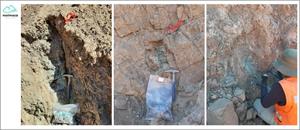
Figure 4: Typical Copper Oxide Exposures
https://www.globenewswire.com/NewsRoom/AttachmentNg/8fef172e-fd71-41cc-98b4-ce3dd518207e
Preparation of drill pads and associated infrastructure at Roble is currently underway and the Company expects to be drilling the target during July 2021. The Company will complete an initial twelve-hole RC drilling program to test key targets at Roble, Nepal and Pele.
Qualified Person
The technical information in this news release, including the information that relates to geology, drilling and mineralization was prepared under the supervision of, or has been reviewed by Sergio Rivera, Vice President of Exploration, Marimaca Copper Corp, a geologist with more than 36 years of experience and a member of the Colegio de Geólogos de Chile and of the Institute of Mining Engineers of Chile, and who is the Qualified Person for the purposes of NI 43-101 responsible for the design and execution of the drilling program.
The QP confirms he has visited the project area, has reviewed relevant project information, is responsible for the information contained in this news release, and consents to its publication.
Contact Information
For further information please visit www.marimaca.com or contact:
Tavistock
+44 (0) 207 920 3150
Jos Simson/Oliver Lamb / Nick Elwes
marimaca@tavistock.co.uk
Forward Looking Statements
This news release includes certain “forward-looking statements” under applicable Canadian securities legislation. There can be no assurance that such statements will prove to be accurate, and actual results and future events could differ materially from those anticipated in such statements. Forward-looking statements reflect the beliefs, opinions and projections on the date the statements are made and are based upon a number of assumptions and estimates that, while considered reasonable by Marimaca Copper, are inherently subject to significant business, economic, competitive, political and social uncertainties and contingencies. Many factors, both known and unknown, could cause actual results, performance or achievements to be materially different from the results, performance or achievements that are or may be expressed or implied by such forward-looking statements and the parties have made assumptions and estimates based on or related to many of these factors. Such factors include, without limitation: risks related to share price and market conditions, the inherent risks involved in the mining, exploration and development of mineral properties, the uncertainties involved in interpreting drilling results and other geological data, fluctuating metal prices, the possibility of project delays or cost overruns or unanticipated excessive operating costs and expenses, uncertainties related to the necessity of financing, the availability of and costs of financing needed in the future as well as those factors disclosed in the annual information form of the Company dated March 29, 2021, the final short form base prospectus and other filings made by the Company with the Canadian securities regulatory authorities (which may be viewed at www.sedar.com). Accordingly, readers should not place undue reliance on forward-looking statements. Marimaca Copper undertakes no obligation to update publicly or otherwise revise any forward-looking statements contained herein whether as a result of new information or future events or otherwise, except as may be required by law.
Neither the Toronto Stock Exchange nor the Investment Industry Regulatory Organization of Canada accepts responsibility for the adequacy or accuracy of this release.

