ONGold Affirms TPK Drill Program Readiness & Reports Exploration Grab Assays up to 17.96 g/t Au Resulting from the 2026 Phase 1 Field Program
Toronto, Ontario--(Newsfile Corp. - August 24, 2026) - ONGold Resources Ltd. (TSXV: ONAU) (OTCQB: ONGRF) (the "Company" or "ONGold") is pleased to report results from its 2026 Phase 1 field exploration program, which consisted of helicopter-supported geological mapping and prospecting, orientation soil sampling at Gold Ridge, Big Dam and Bosworth, and ground geophysical surveying over the Discovery and Discovery West areas at Gold Ridge on the Ti-pi-ha-kaa-ning project (the "TPK Project"). The TPK Project hosts two large independent mineralized systems and comprises 2,835 cell claims covering 76,292 hectares within a highly favourable geological setting. TPK is located on the regional communities' winter-road network, which connects directly to the Musselwhite Gold Mine access road north of Pickle Lake (Figure 1). The Phase 1 program was undertaken to obtain additional field data to inform the Company's planned 2026 permitted drilling program and to complete regional exploration surveys. Wildfires in northwestern Ontario necessitated the rescheduling of the planned summer drilling program to the fall.
Phase 1 Field Program Exploration Highlights:
Gold Ridge:
- Discovery Zone: Structural analysis of drill core has defined a potential southwest-plunging gold-bearing structure at the Discovery Zone. Drill hole GR-25-011, completed in 2025, returned 19.39 g/t Au over a core length of 8.20 m (11.8 to 20.0 m), including 359 g/t Au over 0.30 m (11.8 to 12.1 m). This zone is planned to be further drill tested this fall.
- Sidewinder Zone: The newly discovered Sidewinder Zone, a 70-metre-long gold-bearing quartz-vein shear zone at Gold Ridge, returned grab assays up to 10.69 g/t Au with anomalous copper, including 10.69 g/t Au, 6.48 g/t Au and 5.21 g/t Au. Sidewinder has not been previously drill tested.
- Discovery West: A recently completed ground electromagnetic ("EM") and gravity geophysical survey identified a new EM target approximately 250 metres north of known gold and copper mineralization intersected by drill hole GR-25-012. The target may represent the northern strike extension of the quartz-stockwork vein system that returned 0.30 g/t Au and 1.60 g/t Ag over a core length of 56.4 m. An apparent east-trending shear zone in the same hole returned 11.1% Cu, 218 g/t Ag and 4.45 g/t Au over 0.40 m (319.2 to 319.6 m).
- Boulder Sampling: At Gold Ridge, two new float-boulder grab samples returned 144.68 g/t Au and 28.48 g/t Au, with the latter sample also returning more than 100 ppm Ag.
Other Showings:
- Goose Lake: Additional drilling opportunities have been identified at Goose Lake to explore for high-grade gold mineralization previously intersected by historical drill hole TPK-10-004, which returned 25.87 g/t Au over a core length of 13.50 m (149.3 to 162.8 m), and historical drill hole TPK-11-013, which returned 4.74 g/t Au over a core length of 6.84 m (186.96 to 193.8 m).
- Rowlandson Lake Historical Trenches: Grab sampling of historical trenches returned gold and copper assays of 17.96 g/t Au and 865 ppm Cu, 4.55 g/t Au and 1,910 ppm Cu, and 2.64 g/t Au and 544 ppm Cu.
Kyle Stanfield, Chief Executive Officer and a director of ONGold, commented: "The TPK Project continues to yield a compelling geological story in terms of high-grade gold and the presence of base-metal mineralization. Completion of the Phase 1 exploration program has positioned ONGold for further drilling this fall. Expanding our geological understanding of high-grade gold mineralization at the Discovery Zone will be a key focus, together with drilling other high-grade gold and base-metal targets identified across the TPK Project."
Summer Field Program (Figure 2)
The 2026 field exploration program comprised geological mapping and prospecting and soil-orientation sampling programs (B-horizon and humus) across priority targets, including Gold Ridge, Bosworth, Keely Lake and other prospective mineralized showings throughout the property. Geophysical surveying consisted of 17.8 line-km of ground EM surveying over Discovery West and 15 line-km of gravity surveying across Discovery West and the Discovery Zone.
The survey results have been used to enhance detailed geological and structural interpretation and drill-target selection for the planned fall drill program. Additional mapping was conducted along the newly cut fibre-optic cable line in the Keely Lake area. In total, 93 grab samples and 173 soil and humus samples were collected. Selected grab-sample assay results are summarized in Table 1.
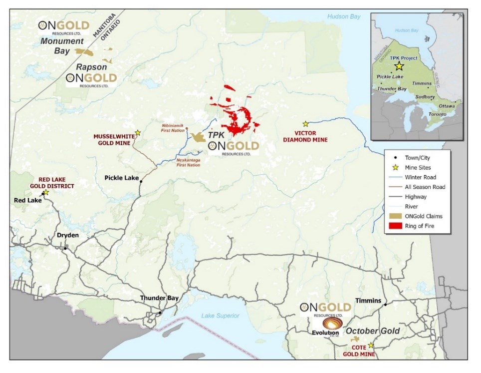
Figure 1: Location Map of the TPK Property in Northern Ontario
To view an enhanced version of this graphic, please visit:
https://images.newsfilecorp.com/files/10770/310917_bf48f4793424d9fc_001full.jpg
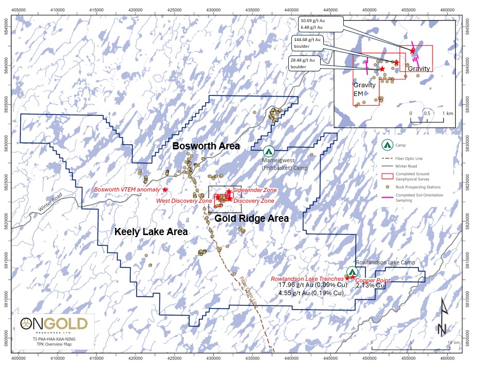
Figure 2: 2026 TPK Field Exploration Target Areas
To view an enhanced version of this graphic, please visit:
https://images.newsfilecorp.com/files/10770/310917_bf48f4793424d9fc_002full.jpg
Grab samples are selective by nature and may not be representative of mineralization on the TPK Project. Float boulders may have been transported from their original bedrock source, and the location, orientation and continuity of the source mineralization have not been established.
Table 1: Selected Assay Results from the Summer Exploration Program
| Prospect Area | Sample | Sample Type | Rock Type | Au (g/t) | Ag (ppm) | Cu (ppm); % Cu | Ni (ppm) | Co (ppm) | Zn (ppm) |
| Sidewinder | C1686314 | Outcrop | quartz vein in diorite | 10.69 | 2.10 | 542 | 34 | 35 | 21 |
| C1686339 | Outcrop | quartz diorite | 6.48 | 1.20 | 356 | 19 | 15 | 18 | |
| C1686306 | Outcrop | quartz diorite | 5.21 | 0.60 | 426 | 24 | 19 | 15 | |
| C1686318 | Outcrop | quartz vein in diorite | 3.40 | 0.90 | 85 | 15 | 7 | 37 | |
| C1686341 | Outcrop | quartz vein in quartz diorite | 3.10 | 1.20 | 263 | 18 | 17 | 5 | |
| C1686317 | Outcrop | diorite | 2.90 | 2.00 | 156 | 11 | 45 | 11 | |
| C1686338 | Outcrop | quartz diorite | 2.26 | 0.60 | 300 | 10 | 32 | 11 | |
| C1686315 | Outcrop | quartz diorite | 1.38 | 0.60 | 318 | 27 | 13 | 62 | |
| C1686316 | Outcrop | diorite | 1.08 | 1.10 | 234 | 17 | 8 | 17 | |
| C1686342 | Outcrop | quartz diorite | 0.89 | 0.60 | 275 | 23 | 19 | 19 | |
| Gold Ridge | C1686301 | Boulder | quartz vein | 144.68 | 1.70 | 138 | 85 | 1,140 | 6 |
| C1686313 | Boulder | quartz vein in diorite | 28.48 | >100 | 5 | 11 | 3 | 21 | |
| C1686307 | Boulder | diorite | 1.02 | 5.50 | 1,650; 0.17% | 68 | 56 | 79 | |
| Rowlandson Lake | C1686337 | Outcrop | quartz vein in gabbro | 17.96 | 0.25 | 865 | 109 | 103 | 277 |
| C1686404 | Outcrop | mafic volcanic | 4.55 | 0.25 | 1,910; 0.19% | 194 | 51 | 143 | |
| C1686403 | Outcrop | mafic volcanic | 2.64 | 0.25 | 544 | 89 | 32 | 80 | |
| Copper Point | C1686409 | Outcrop | gabbro | 0.172 | 2.90 | 19,600; 1.96% | 630 | 121 | 67 |
| C1686407 | Outcrop | mafic volcanic | 0.147 | 3.20 | 21,300; 2.13% | 810 | 203 | 129 | |
| C1686335 | Outcrop | gabbro | 0.101 | 2.40 | 13,700; 1.37% | 1,170 | 179 | 87 | |
| C1686336 | Outcrop | gabbro | 0.069 | 0.50 | 8,280; 0.83% | 2,030 | 286 | 94 | |
| C1686408 | Outcrop | gabbro | 0.034 | 0.25 | 5,020; 0.50% | 684 | 120 | 83 |
Gold Ridge
Discovery and Discovery West
The ground geophysics program identified a new EM target approximately 250 metres north, along the interpreted northwestern strike extension of the gold-bearing quartz-stockwork zone previously intersected by ONGold drill hole GR-25-012. Preliminary examination of the soil data indicates that elevated gold values in humus samples over the Discovery Zone appear to correlate with known gold intercepts in historical drill core and the newly identified EM anomaly.
Sidewinder Zone
The newly discovered Sidewinder Zone, identified through surface mapping and prospecting, is part of multiple subparallel gold-bearing shears and veins in the Discovery Zone area. Sidewinder is located approximately 250 metres north of the Discovery Zone, with two new subparallel zones located within 100 metres east of Sidewinder. Historical drilling in the area is shown in Figure 3. This northeast-trending, steeply dipping shear has been outlined for approximately 70 metres, is up to 0.5 m wide at surface and is open to the south. It is hosted in strongly sericite-altered, silicified and sheared quartz diorite and diorite with local quartz veinlets.
Mineralization consists of 5% to locally 10% medium-grained disseminated pyrite with minor chalcopyrite and returned gold values up to 10.69 g/t Au from grab sampling. Higher gold grades (>3.0 g/t Au) within the selected sample population were associated with quartz veining and copper mineralization. To date, Sidewinder has not been drill tested.
Goose Lake Prospect
A field inspection was completed at the Goose Lake Prospect in preparation for future drilling. Historical drill casings were located, but no outcrop was found in the area visited. Overburden depths in historical holes range from 2 to 19 metres in the immediate area. Historical drill intercepts of interest for future targeting include the following (Figure 4):
- TPK-10-004 intersected 25.87 g/t Au over a core length of 13.50 m (149.3 to 162.8 m), including 46.0 g/t Au over 0.50 m (153.0 to 153.5 m), 139.40 g/t Au over 1.7 m (156.8 to 158.5 m), including 749.0 g/t Au over 0.3 m (157.2 to 157.5 m), and 127.0 g/t Au over 0.7 m (162.0 to 162.7 m); and
- TPK-11-013 was drilled in the opposite direction and intersected 4.74 g/t Au over a core length of 6.84 m (186.96 to 193.8 m), including 15.52 g/t Au over 1.5 m (192.3 to 193.8 m) and 33.90 g/t Au over 0.5 m (192.3 to 192.8 m).
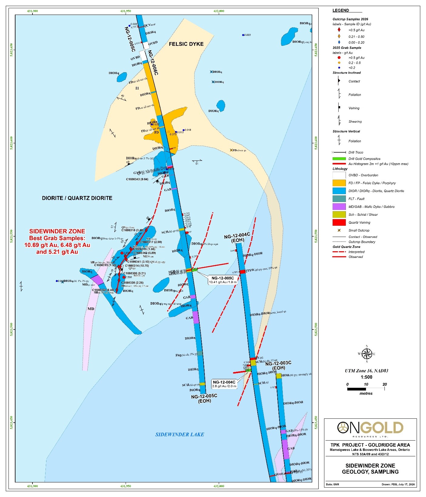
Figure 3: Sidewinder Zone at Gold Ridge; Up to 10.7 g/t Au in Grabs
To view an enhanced version of this graphic, please visit:
https://images.newsfilecorp.com/files/10770/310917_bf48f4793424d9fc_003full.jpg
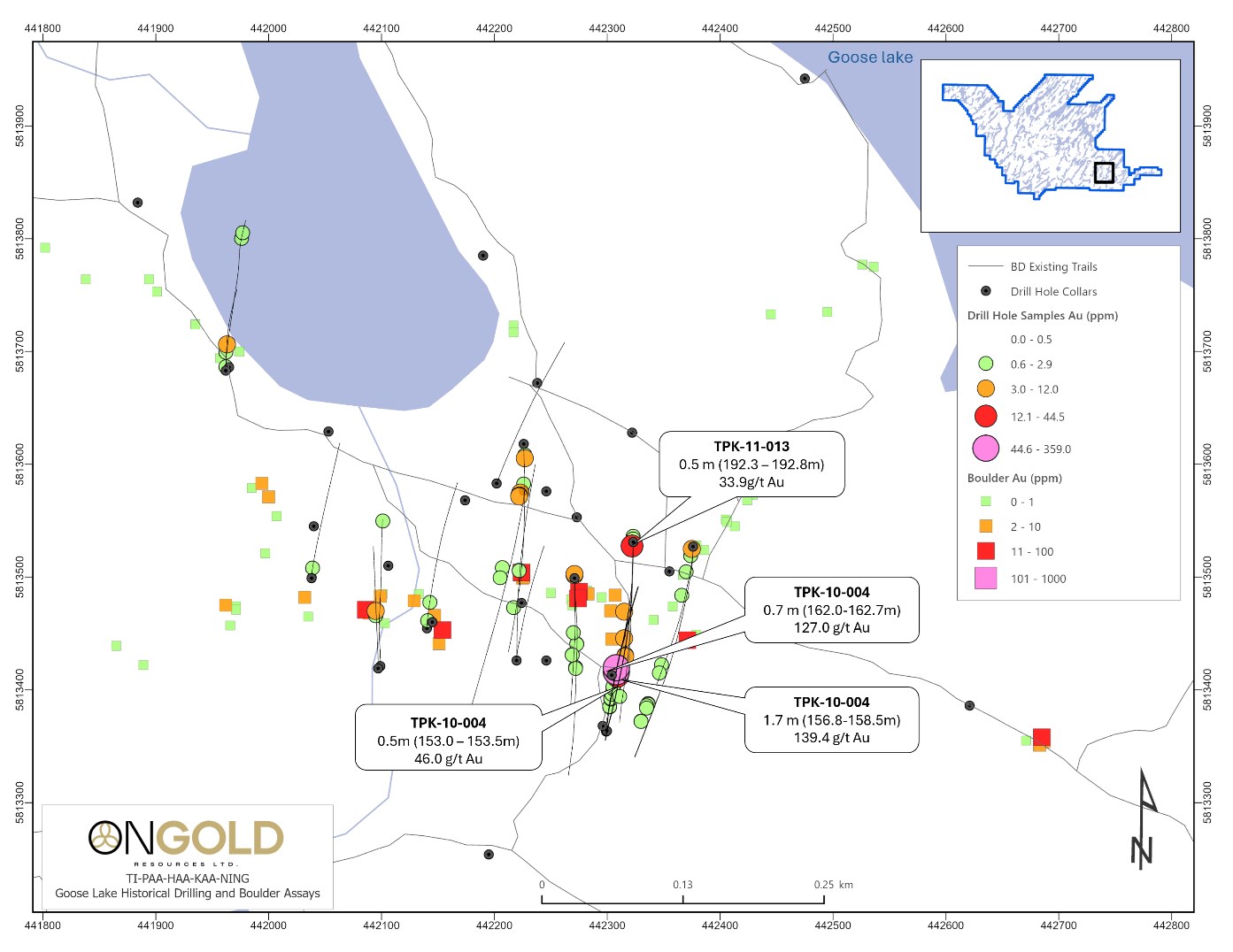
Figure 4: Historical Drilling and Boulder Sampling at the Goose Lake Prospect and Big Dam
To view an enhanced version of this graphic, please visit:
https://images.newsfilecorp.com/files/10770/310917_bf48f4793424d9fc_004full.jpg
The current interpretation of drilling in this area suggests that the zone may plunge to the southeast, where no historical drill testing was completed. The high-grade gold zone may represent an intersection between regional east-west and northwest-trending fault structures. Future drilling is expected to use oriented core to collect structural data and evaluate the plunge directions of gold-bearing veins and the potential to expand gold mineralization at this interpreted structural junction.
Crying Boy Lake
Field work was completed around Crying Boy Lake to investigate the source of the historical gold-in-till anomaly from reverse-circulation ("RC") till sampling and the gold-in-boulder anomaly southwest of the shoreline. Historical drill casings were located, but no outcrop was found in the area visited. Historical drill hole TPK-12-30, drilled to test an induced polarization anomaly, returned 59.6 g/t Au and 93.3 g/t Ag over a core length of 0.5 m (225.0 to 225.5 m). The Company interprets this result as potentially associated with a regional east-trending gold-silver-bearing structure that may be one of the principal sources, or one of multiple parallel sources, for gold in till located south, within and east of Crying Boy Lake. A potentially parallel structure was intersected by historical drill hole TPK-12-034, which returned 16.15 g/t Au over a core length of 1.5 m (66.3 to 67.8 m) in quartz-veined quartz monzonite with trace pyrite. Two historical boulder grab samples collected within 130 metres of the eastern shoreline returned 40.8 g/t Au and 27.0 g/t Au.
Rowlandson Lake
West of Copper Point, the historical Rowlandson Lake trenches were ground-truthed and six bedrock samples and one boulder sample were collected. Assay results returned 2.64 g/t Au to 17.96 g/t Au and elevated copper values. Historical drill testing returned 4.0 g/t Au over a core length of 0.4 m in hole CAN08-035 (74.5 to 74.9 m), hosted in diorite; 3.50 g/t Au over a core length of 1.3 m in hole FRI84-1 (10.8 to 12.1 m), hosted in intermediate volcanics; and 2.25 g/t Au over a core length of 1.5 m in hole RL03-03 (156.0 to 157.5 m), hosted in diorite. Historical trench sampling returned values up to 80.2 g/t Au.
Qualified Person and Data Verification
The scientific and technical information in this news release has been reviewed and approved by Paul Dunbar, P.Geo., Vice President Exploration of ONGold, a "Qualified Person" as defined in National Instrument 43-101 - Standards of Disclosure for Mineral Projects. Mr. Dunbar is not independent of the Company. The Qualified Person has verified the 2026 exploration results disclosed in this news release through a review of the applicable assay certificates, sampling records and quality assurance and quality control data. Historical exploration results have been reviewed against historical records available to the Company. The Qualified Person has not independently verified all historical sampling and drilling procedures or all underlying historical assay data, but considers the historical information sufficiently reliable for the limited purpose of guiding the Company's current exploration activities. All historical drill intervals reported in this news release are core lengths. True widths have not been determined.
QA/QC and Assay Procedures
Quality assurance and quality control ("QA/QC") procedures were implemented for the 2026 field program. Rock grab samples were placed in security-sealed bags for shipment, and approximately 5% of the rock samples were dispatched to a secondary laboratory for check assays. Commercially prepared certified reference material standards and blanks were inserted as part of the QA/QC program.
Samples were analyzed at Activation Laboratories ("Actlabs") facilities in Thunder Bay and Ancaster, Ontario, which are ISO 17025 and ISO 9001 certified. Samples were initially analyzed by 50-gram fire assay with an atomic absorption finish. Any sample assaying greater than 5 g/t Au was reassayed by fire assay with a gravimetric finish. Selected samples were analyzed using a screened-metallics method.
Geochemical analyses were performed by Actlabs and consisted of aqua regia digestion and analysis for 38 elements by inductively coupled plasma ("ICP") methods. Overlimit samples were reassayed for silver and copper by aqua regia digestion using inductively coupled plasma optical emission spectroscopy ("ICP-OES"), Actlabs method 8-AR-ICP-OES. A 0.5 g sample was digested in aqua regia and diluted volumetrically to 250 mL with 18-megaohm water. Certified reference materials for the appropriate elements were digested in the same manner and used as verification standards.
Soil and humus samples collected for the orientation soil program were placed in security-sealed bags for shipment to Actlabs in Thunder Bay for analysis. Field duplicate samples were collected every tenth sample. Samples were dried at 60°C and sieved to minus 80 mesh, then analyzed for gold by 30-gram fire assay with an atomic absorption finish. Multielement analyses were performed by Actlabs using aqua regia digestion and ICP-OES, Actlabs method 1E3.
Updated Collaboration Agreement
The Company is pleased to announce that ONGold and Nibinamik First Nation have entered into an updated collaboration agreement governing the Company's 2026 exploration activities at the TPK Project. The prior 2025 agreement between the Company and Nibinamik First Nation was updated and includes various provisions including the proposed issuance of common shares of the Company to Nibinamik First Nation, subject to TSX Venture Exchange approval and satisfaction of applicable securities law requirements.
About ONGold Resources Ltd.
ONGold Resources Ltd. owns significant exploration assets in Northern Ontario and Northern Manitoba, including the district-scale Monument Bay Gold and Tungsten Project, TPK Project, Domain Gold Project and October Gold Project. These projects represent a strategic footprint in one of Canada's most prolific gold-producing regions.
With its extensive technical expertise, strong commitment to social acceptability, mindful Indigenous engagement and partnerships, in addition to a proven track record of responsible exploration, ONGold's team is uniquely positioned to unlock the full potential of its portfolio of projects.
ONGold Resources Ltd. on behalf of the Board of Directors
Kyle Stanfield, Chief Executive Officer & Director
Contact Information
Kyle Stanfield
Chief Executive Officer
Telephone: 1-647-749-5836
Email: info@ongoldresources.com
Neither the TSX Venture Exchange nor its Regulation Services Provider (as that term is defined in the policies of the TSX Venture Exchange) accepts responsibility for the adequacy or accuracy of this release.
Cautionary Note Regarding Forward-Looking Information:
This news release contains "forward-looking information" within the meaning of applicable Canadian securities laws. Forward-looking information includes, but is not limited to, statements regarding the timing, scope and targets of the Company's planned fall 2026 drill program; the Company's geological and structural interpretations; the possible extension or continuity of mineralized structures; the significance of geophysical, geochemical and sampling results; planned follow-up work and future drilling at the Discovery Zone, Discovery West, Sidewinder, Goose Lake, Crying Boy Lake and Rowlandson Lake; the proposed use of oriented drill core; future verification of historical information; and the proposed issuance of common shares to Nibinamik First Nation and receipt of TSX Venture Exchange approval. Generally, forward-looking information can be identified by the use of forward-looking terminology such as "plans," "expects," "is expected," "intends," "anticipates," "believes," "may," "could," "would," "might" or "will."
Forward-looking information is based on management's reasonable assumptions, estimates and expectations as of the date of this news release, including assumptions regarding access to the TPK Project; weather, wildfire and seasonal conditions; the availability of personnel, contractors and equipment; the performance of third-party service providers; the timing and receipt of permits, approvals and consents; the reliability of available historical information for exploration targeting; community engagement; and receipt of TSX Venture Exchange approval for the proposed share issuance.
Forward-looking information is subject to known and unknown risks, uncertainties and other factors that may cause actual results to differ materially from those expressed or implied. These risks and uncertainties include risks inherent in mineral exploration; geological and interpretation risk; the selective nature of grab samples and uncertainty regarding the source of float boulders; the possibility that follow-up work will not confirm the Company's interpretations; operational and logistical risks, including access, wildfire conditions, contractor and equipment availability and supply constraints; permitting and regulatory delays; failure to obtain TSX Venture Exchange approval; environmental and community-engagement risks; laboratory and analytical delays; commodity-price volatility; and general business, economic, competitive and market conditions.
Readers are cautioned not to place undue reliance on forward-looking information. The Company undertakes no obligation to update or revise forward-looking information, whether as a result of new information, future events or otherwise, except as required by applicable law.

To view the source version of this press release, please visit https://www.newsfilecorp.com/release/310917