The drill is back at VR's Reveille property in Nevada to test the jasperoid breccia-pipe gold target named G1
VANCOUVER, British Columbia, April 14, 2021 (GLOBE NEWSWIRE) -- VR Resources Ltd. (TSX.V: VRR, FSE: 5VR; OTCBB: VRRCF), the "Company,” or “VR,” is pleased to confirm that the drill is back on site and turning at its Reveille property in Nevada.
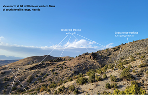
VR was able to secure a track-mounted diamond drill rig on route to a nearby project in order to complete a core hole on the jasperoid breccia-pipe gold target at Reveille named G1. As shown in the field photograph from yesterday in Photo 1, the drill hole is located on a ridge of structurally-controlled, gold-bearing jasperoid breccia related to a rhyolite intrusion which has replaced the host limestone stratigraphy along a fold hinge fault zone, with high-grade silver and copper in breccia zones to the northeast of G1 along the same structure.
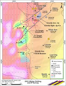
As shown on the drill hole plan map in Figure 1, and as summarized in the News Release dated March 17, 2021, VR completed four RC (reverse circulation) holes in February for a total of f 4,347 feet by a truck-mounted TH75 rig, each hole between 1,000 and 1,200 ft long, and each hole on a different target based on integrated data from structural mapping and rock geochemistry, and gravity, EM and magnetic geophysical surveys. The G1 gravity target was not tested because the drill road and pad were not amenable to the truck mounted RC rig.
Soil Anomaly
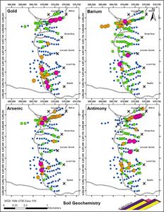
While drilling the first four RC holes in February, the Company received the geochemical data from a soil sample grid covering the entire western flank of the range and the western third of the property. The data set is robust, consisting of 287 samples on a 50 - 150 m spacing. As shown in Figure 2, the strongest gold anomaly on the entire Reveille property occurs at G1, in association with the ridge spur of jasperoid breccia, and strongly correlated with arsenic-antimony-mercury and barium.
Gravity Anomaly
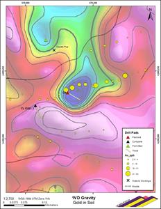
As shown in Figure 3, the G1 drill hole itself is collared specifically on a high contrast and sharply defined gravity low anomaly and coincident multi-element soil anomaly in gold-arsenic-antimony-mercury-barium associated with extensive outcrops of jasperoid breccia on the ridge. The G1 drill hole will test if the gravity anomaly is a decalcified, and therefore low density, gold-bearing jasperoid breccia-pipe developed in the host limestone. The contours of the gravity indicate a sub-vertical, pipe-like geometry for the body, with a strong structural control.
The geochemical attributes of the jasperoid and the soil anomaly are characteristic of a Carlin-style fluid system. It developed on the same overall regional fault complex and caldera margin setting which accommodated the silver-copper CRD fluid system that was responsible for the historic workings in the hills to the east of G1 (Photo 1). That is, the silver-copper and gold fluid systems are superimposed, which speaks to the strength of both the system driver and the host structure at Reveille.
Context
VR is exploring the covered valley on the western flank of the range because it has never been previously explored or drilled as the potential source and overall driver of the high-grade silver-copper mineralization at Reveille during the past 140 years of prospecting which has focused on the high-grade showings exposed in the hills of the Reveille range to the east.
VR is focused squarely on targets for proximal, high temperature mineralization that represents the core to the overall CRD mineral system and source to the showings in the hills at Reveille, and the superimposed gold-
arsenic-antimony-mercury-barium jasperoid anomaly, based on an array of new geochemical data and element ratio vectors which point to the western range flank and covered valley as the source area.
Comment
From VR’s CEO Dr. Michael Gunning, “Committing to the diamond drill rig you see in Photo 1 at the G1 pad as it was on it’s way north to another job speaks to our conviction on both the definition and the amplitude of the gravity and multi-element geochemical anomaly, and to the upside potential of this jasperoid breccia body to our shareholders.
Obtaining drill core as opposed to RC chips will give us stronger geological logs, better data from hyperspectral scanning for mineral alteration, valuable high definition photography of the entire hole, and stronger control for geochemical sampling and interpretation of data in the context of detailed geological logs.
Hyperspectral scanning on the first four RC holes completed last month is nearly complete now, and more than 800 geochemical samples from continuous sampling of each of the first four holes in their entirety are through the preparation lab and are in the queue for final analysis. Overall, we hope to have all geochemical data from the initial 4 holes by earliest May.
To be clear, our intent is to lay out a Phase II drill program at Reveille using the new geochemical data from the first five holes, in addition to the final inversion models from the 3D-array DCIP geophysical survey that was also completed in February, and for which we have seen preliminary results.
We look forward to providing further updates as our data come in and our drilling advances at Reveille this spring and summer.”
Technical Information
Summary technical and geological information for the Company’s various exploration properties is available at the Company’s website at www.vrr.ca.
VR has submitted RC chip samples collected from this drill program for geochemical analysis to the Bureau Veritas Minerals (“BV”) laboratory in Sparks, Nevada, where sample preparation is completed. Analytical work completed at the BV laboratories located in Vancouver, BC., includes ICP-MS analyses for base metals and trace elements, while gold determination is done at the Sparks, NV lab by fire assay atomic absorption spectrometry. Analytical results are subject to industry-standard and NI 43-101 compliant QAQC sample procedures at the laboratory, as described by BV, and with standard, duplicate and blank samples inserted internally by the company.
Technical information for this news release has been prepared in accordance with the Canadian regulatory requirements set out in National Instrument 43-101. Justin Daley, P.Geo., Exploration Manager & Chief Geologist at VR and a non-independent Qualified Person oversees and/or participates in all aspects of the Company’s mineral exploration projects and has reviewed the content of this news release. The Company’s CEO, Dr. Michael Gunning, P.Geo., is also a non-independent Qualified Person.
About the Reveille Property
The Reveille property is located approximately 90 km’s east of Tonopah, Nevada. Access is via Highway 6, with local roads and trails in and around the property itself.
The Reveille property consists of 66 mineral claims in one contiguous block covering 1,344 acres (544 hectares) over an area of approximately 2 x 3 km’s. The property is on federal land administered by the BLM, and are outside of the BLM’s broadly defined area of sage grouse protection. There are no underlying annual lease payments on the property, nor are there any joint venture or carried interests on the property. There is an industry-standard royalty attached to the property, with a standard buy-back provision to VR.
About VR Resources
VR is an established junior exploration company focused on greenfields opportunities in copper and precious metals (TSX.V: VRR; Frankfurt: 5VR; OTCBB: VRRCF). VR is the continuance of 4 years of active exploration in Nevada by a Vancouver-based private company. The diverse experience and proven track record of its Board in early-stage exploration, discovery and M&A is the foundation of VR. The Company focuses on underexplored, large-footprint mineral systems in the western United States and Canada, and is well financed for its exploration strategies and corporate obligations. VR owns its properties outright, and evaluates new opportunities on an ongoing basis, whether by staking or acquisition.
The Company continues its normal course of business in 2021 within the framework of modified exploration programs in response to the COVID-19 pandemic, with the goal of ensuring the health and safety of staff and project personnel.
ON BEHALF OF THE BOARD OF DIRECTORS:
“Michael H. Gunning”
____________________________
Dr. Michael H. Gunning, PhD, PGeo
President & CEO
For general information please use the following:
| Website: | www.vrr.ca |
| Email: | info@vrr.ca |
| Phone: | 604-262-1104 |
Forward Looking Statements
This press release contains forward-looking statements. Forward-looking statements are typically identified by words such as: believe, expect, anticipate, intend, estimate, postulate and similar expressions or are those which, by their nature, refer to future events. Forward looking statements in this release include “VR is focused squarely on targets for proximal, high temperature mineralization that represents the core to the overall CRD mineral system and source to the showings in the hills at Reveille.”, and “VR evaluates new opportunities on an ongoing basis, whether by staking or acquisition.”
This news release contains statements and/or information with respect to mineral properties and/or deposits which are adjacent to and/or potentially similar to the Company’s mineral properties, but which the Company has no interest in nor rights to explore. Readers are cautioned that mineral deposits on adjacent or similar properties are not necessarily indicative of mineral deposits on the Company’s properties.
Although the Company believes that the use of such statements is reasonable, there can be no assurance that such statements will prove to be accurate, and actual results and future events could differ materially from those anticipated in such statements. The Company cautions investors that any forward-looking statements by the Company are not guarantees of future performance, and that actual results may differ materially from those in forward-looking statements. Trading in the securities of the Company should be considered highly speculative. Readers are urged to review all of the Company’s public disclosure filings available at www.sedar.com.
Neither the TSX Venture Exchange nor its Regulation Services Provider (as that term is defined in Policies of the
TSX Venture Exchange) accepts responsibility for the adequacy or accuracy of this release
Photo 1 accompanying this announcement is available at https://www.globenewswire.com/NewsRoom/AttachmentNg/ecaf877d-6df0-4fda-b036-be8bd832990b
Figure 1 accompanying this announcement is available at https://www.globenewswire.com/NewsRoom/AttachmentNg/03d72e8a-9342-4c31-8c0b-d8595997736d
Figure 2 accompanying this announcement is available at https://www.globenewswire.com/NewsRoom/AttachmentNg/b9774d61-5ef7-4f92-9809-3a5b0a8c09f6
Figure 3 accompanying this announcement is available at https://www.globenewswire.com/NewsRoom/AttachmentNg/0e5389da-46ff-40ef-9aac-34c127268139


