Trenching Extends Mineralization in Two Zones at Las Conchitas
(TheNewswire)
TheNewswire / Golden Reign Resources Ltd. (TSX-V: GRR) (the “Company” or “Golden Reign”) announces recently received trenching results from the Las Conchitas area of its wholly-owned San Albino-Murra Property (the “Property”) in Nueva Segovia, Nicaragua.
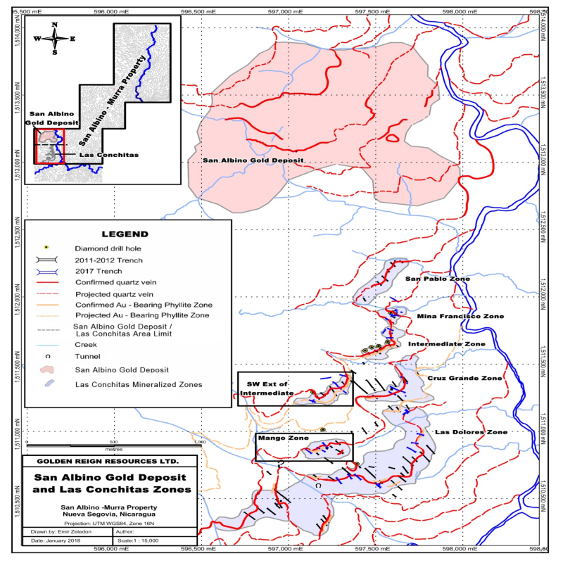
Recent trenching has extended two known mineralized zones. A 250 metre long zone named the “SW Extension” appears to be a continuation of the Intermediate Zone to the southwest, for a total strike length of 600 metres, after a 125 metre break in sampling. The Mango Zone has been extended 150 metres to the southwest.
The Intermediate and Mango zones are two of seven parallel mineralized zones within the Las Conchitas area targeted by the Company’s 2017 trenching program. The Las Conchitas area covers a total area of approximately 4 km2, or roughly twice the size of the San Albino Gold Deposit being advanced towards production by Golden Reign.
Intermediate Zone - SW Extension
In 2011, the Company conducted its initial trenching campaign in the Las Conchitas area, identifying the highly mineralized Intermediate Zone.
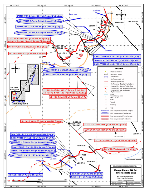
During 2017, closely spaced trenching of the SW Extension of the Intermediate Zone was completed in order to further define near-surface high-grade mineralization within the zone and improve confidence in the grade and continuity of these shallow dipping structures. The SW Extension and Intermediate Zone now have a combined strike length of approximately 600 metres, but remain separated by 125 metres still to be tested (please see maps San Albino Gold Deposit and Las Conchitas Zones and Mango Zone – SW Ext Intermediate Zone).
The surface exposure of the SW Extension has been confirmed for a strike length of at least 250 metres, using trench spacing of 50 metres or less. Sampling of the mineralized zone within trench SAM17-TR 07 returned values of:
---------------------------------------------------------- |- 8.7 m of 8.50 g/t gold and 11.5 g/t silver (along dip)| |--------------------------------------------------------| |- 0.5 m of 25.40 g/t gold and 24.6 g/t silver (vertical)| ----------------------------------------------------------More significantly, trenching and comprehensive sampling of the country rock (phyllites) has established a separate mineralized horizon lying below the vein mineralization and confirmed that gold is not restricted solely to the quartz veins but is also distributed within the host rock. Highlights of the mineralized country rock horizon within the trench SAM17-TR07 are as follows:
----------------------------------------------------------- |- 10.0 m of 9.64 g/t gold and 13.8 g/t silver (along dip)| |---------------------------------------------------------| |- 0.7 m of 9.90 g/t gold and 9.05 g/t silver (vertical) | |---------------------------------------------------------| |- 1.9 m of 5.43 g/t gold and 4.8 g/t silver (vertical) | -----------------------------------------------------------Trenches SAM17-TR11 and SAM17-TR12 have also revealed historical surface workings and mine dumps. The highest gold values within those dumps are as follow:
---------------------------------------------------------------------- |-|SAM17-TR07 |2.2 m of 13.35 g/t gold and 20.3 g/t silver (vertical)| |--------------------------------------------------------------------| |-|SAM17-TR11 |0.8 m of 27.60 g/t gold and 17.4 g/t silver (vertical)| |--------------------------------------------------------------------| |-|SAM17-TR11 |1.9 m of 4.81 g/t gold and 6.9 g/t silver (vertical) | |--------------------------------------------------------------------| |-|SAM17-TR11 |0.6 m of 23.40 g/t gold and 27.4 g/t silver (vertical)| |--------------------------------------------------------------------| |-|SAM17-TR12 |2.0 m of 8.65 g/t gold and 6.0 g/t silver (vertical) | |--------------------------------------------------------------------| |-|SAM17-TR12 |2.0 m of 4.42 g/t gold and 6.2 g/t silver (vertical) | ----------------------------------------------------------------------Trenches SAM17-TR08, SAM17-TR09 and SAM17-TR10 were designed to test small geochemical soil anomalies along the dip of the zone; however, sampling has returned gold values below a cut-off grade of 1.0 g/t of gold.
Mango Zone
Three trenches completed at the Mango zone have confirmed the 150 metre south-westerly extension of the mineralized structure, previously tested only by drilling at depth and exposed by a single trench LC11-TR 01 (2.0 metre of 26.27 g/t gold and 17.4 g/t silver (along dip), see news release February 25, 2013). Highlights are as follow:
---------------------------------------------------------------------- |-|SAM17-TR15 |1.1 m of 11.23 g/t gold and | | | |65.2 g/t silver (along dip) | |--------------------------------------------------------------------| |-|SAM17-TR16 |2.5 m of 6.74 g/t gold and 2.5 g/t silver (vertical) | |--------------------------------------------------------------------| |-|SAM17-TR20 |1.8 m of 13.00 g/t gold and 11.1 g/t silver (vertical)| ----------------------------------------------------------------------Further trenching is required to test the continuity of this highly prospective mineralized structure, which remains open in along strike and down dip (please see maps San Albino Gold Deposit and Las Conchitas Zones and Mango Zone – SW Ext Intermediate Zone).
The down dip extent of the Mango zone was tested in 2011 by five drill holes (see news release February 25, 2013), demonstrating that the high-grades of ≥ 1 m in width continue to a depth of at least 400 metres:
--------------------------------------------------------- |-|LC11-01 |3.0 m of 62.96 g/t | | | |gold and 61.7 g/t | | | |silver | |-------------------------------------------------------| |-|LC11-02 |1.2 m of 29.80 g/t | | | |gold and 31.7 g/t | | | |silver | |-------------------------------------------------------| |-|LC11-03 |1.0 m of 36.50 g/t | | | |gold and 60.6 g/t | | | |silver | |-------------------------------------------------------| |-|LC11-04 |1.5 m of 9.44 g/t gold and 17.3 g/t silver| |-------------------------------------------------------| |-| |0.6 m of 20.64 g/t | | | |gold and 37.0 g/t | | | including|silver | |-------------------------------------------------------| |-|LC11-05 |5.0 m 8.63 g/t gold and 3.5 g/t silver | |-------------------------------------------------------| |-| |1.0 m of 35.70 g/t gold and 2.0 g/t silver| | | | | | | including| | ---------------------------------------------------------Trenching of the Mango zone revealed a historical mine dump (40m x 30m x 3m) produced from historical artisanal workings. This mining was conducted informally by local residents in the early 1900’s, as a supplement to agricultural income.
Previous sampling and testing of historical workings indicates that frequently a small exposed portion of the mineralized structure had been removed but the majority of the structure remains intact. The best values returned from sampling of the mine dump material in trench SAM17-TR15, utilizing a cut-off grade of 1.0 g/t Au, are shown below:
-------------------------------------------------------- |-|3.0 m of 2.42 g/t gold and 1.9 g/t silver (parallel)| |------------------------------------------------------| |-|2.0 m of 2.18 g/t gold and 4.9 g/t silver (vertical)| |------------------------------------------------------| |-|3.1 m of 1.46 g/t gold and 2.7 g/t silver (vertical)| |------------------------------------------------------| |-|1.0 m of 5.82 g/t gold and 6.7 g/t silver (vertical)| --------------------------------------------------------For a complete list of trenching results, please see the table titled “2017 Las Conchitas Trenching Results” available on our website at www.goldenreignresources.com.
The southern Las Conchitas area hosts a significant emerging cluster of gold targets. This latest work has shown that some of these may join up. Las Conchitas is situated immediately south of the San Albino Gold Deposit at the southwest end of Corona de Oro Gold Belt which, at 3 kilometres wide and 20 kilometres long, is spanned by the Company’s landholdings.
The mineralized intervals shown above utilize a 1.0 g/t gold cut-off grade. The results presented above are preliminary in nature. There has been insufficient exploration to date to estimate a “Mineral Resource”, as such term is defined in National Instrument 43-101 “Standards of Disclosure for Mineral Projects”. There is no certainty that further exploration will result in the identification of Mineral Resources.
QA&QC Procedures
The Company follows industry standards in its QA&QC procedures. A certified standard sample, or a blank or a field duplicate sample is inserted every 10 samples before the set of samples are sent to the Laboratory. This procedure is applied to all drill and trench samples.
Qualified Person
John M. Kowalchuk, P.Geo, a geologist and qualified person (as defined under NI 43-101) has read and approved the technical information contained in this news release. Mr. Kowalchuk is a senior geologist consulting to the Company.
On behalf of the Board,
“Kevin Bullock”
CEO
About Golden Reign:
Golden Reign Resources Ltd. is a publicly listed (TSX-V: GRR) mineral exploration company engaged in exploring the San Albino-Murra Property and the El Jicaro Property, both of which are located in Nueva Segovia, Nicaragua.
The Company’s prime objective is to bring its San Albino Gold Deposit into production quickly and efficiently, building cash flow to further advance a number of its other prospective exploration targets.
The Company’s land package comprises 13,771 hectares (138 km2) of prospective ground for gold and silver mineralization. Hundreds of historical mines and workings exist within the Corona de Oro Gold Belt, which is approximately 3 kilometres wide by 20 kilometres long and is spanned by the Company’s land package.
For additional information please visit our website at www.goldenreign.com and SEDAR www.sedar.com.
Forward-Looking Statements: Some of the statements contained herein may be considered “forward-looking information” within the meaning of applicable securities laws. Forward-looking information is based on certain expectations and assumptions, including the assumption that the Company’s exploration program will be successfully completed, and are subject to known and unknown risks and uncertainties. Such forward-looking information is subject to a variety of risks and uncertainties which could cause actual events or results to differ materially from those reflected in the forward-looking information, including, without limitation, the risk that satisfactory exploration results will not be obtained, the risk that exploration results will not translate into the discovery of an economically viable deposit, risks and uncertainties relating to political risks involving the Company’s exploration and development of mineral properties interests, the inherent uncertainty of cost estimates and the potential for unexpected costs and expenses, commodity price fluctuations, the inability or failure to obtain adequate financing on a timely basis and other risks and uncertainties. Such information contained herein represents management’s best judgment as of the date hereof, based on information currently available.
Neither the TSX Venture Exchange nor its Regulation Services Provider (as that term is defined in the policies of the TSX Venture Exchange) accepts responsibility for the adequacy or accuracy of this release.
Copyright (c) 2018 TheNewswire - All rights reserved.

