VR reports new gold and silver mineralization at the G1 and Kawich targets at its Reveille project in Nevada, stakes additional ground and plans follow-up exploration
VANCOUVER, British Columbia, Oct. 06, 2021 (GLOBE NEWSWIRE) -- VR Resources Ltd. (TSX.V: VRR, FSE: 5VR; OTCQB: VRRCF), the "Company,” or “VR,” is pleased to report that is has received all of the rock and mineral chemistry data from drilling this summer on its Reveille silver-copper project in west-central Nevada.
- silver is confirmed in the large G1 breccia pipe, up to 97.9 g/t;
- gold is confirmed over a 40m interval within the broad, 150 m pyrite intersections at Kawich;
- Kawich is confirmed as the potential porphyry center driving Reveille based on a clear, high temperature, copper-moly-tungsten-antimony geochemical signature of the gold-bearing pyrite alteration zone;
- the property has been expanded westward to cover the entirety of the Kawich target area, and eastward to cover an EM conductor not previously explored and targeted for a covered copper-silver manto.
From VR’s CEO, Dr. Michael Gunning, “We are pleased to have the first-pass drilling of our primary targets at Reveille completed. Both G1 and Kawich are new discoveries; they expand the breadth of the Reveille system westward from the exposed range where the historic workings are located, and they confirm the presence of a hydrothermal gold overprint in the district. But perhaps most importantly, there is a high temperature, base metal signature for the broad, gold-bearing pyrite alteration facies at Kawich which demonstrates its potential as a large-scale porphyry center and driver for Reveille, which is what we came to this historic district to explore for.
The figures and photos which follow in the body of this news release will illustrate for you the key findings from the first-pass drilling completed so far at Reveille, and also the lay of the land with regard to our expansion of the property to cover more of the polymetallic and high temperature mineral system at Reveille.
We will take the next few months to fully integrate and fully interpret an extremely large data set from the continuous geochemical sampling and hyperspectral scanning of all nine drill holes completed this year in order to formulate the right follow-up plan for 2022. We anticipate the focus to be on the large, gold-bearing pyrite alteration system at Kawich given its sheer size, and the clarity of the high-temperature geochemical and hyperspectral mineral vectors towards Kawich which are already evident from the first-pass analysis of the data.
In the meantime, we are back on the ground completing reconnaissance soil sampling and prospecting on the newly staked, buried conductor named “Big Apple” on the east side of the range that was discovered by our high resolution airborne EM survey completed last year. There is no previous exploration in the area of Tertiary volcanic cover. The silver-bearing breccia body at G1 was discovered as the result of integrating a wide array of data from airborne and ground geophysics, soil and rock geochemistry and stratigraphic and structural relationships from mapping. In isolation, however, the new Big Apple target on the east side of the range is the single-strongest conductive feature in the entire survey block from 2020. With that, we will integrate data from mapping and rock and soil sampling completed this month to refine the targeting around the Big Apple conductor and include it in our prioritization of work for next year on Kawich and G1.
On a broader note, the Company continues with its core strategy for 2021 to complete drill programs on its three highest priority properties and targets, namely Reveille and Amsel in Nevada and Hecla-Kilmer (“H-K”) in northern Ontario. The drill is currently turning on the copper-gold hydrothermal breccia target at H-K, and we continue to plan for a drill program later this fall on our Amsel gold property in Nevada, pending receipt of our drill permit. We look forward to providing further updates as our exploration continues towards realizing for our shareholders the upside potential of blue-sky discovery on any number of these properties.”
Reveille Drilling Summary and Results
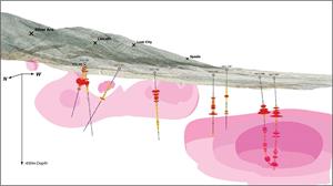
Figure 1. Eight RC drill holes and one diamond drill hole were completed on and around the G1 and Kawich targets on the covered, western flank of the Reveille range in 2021, for a total of 2,987 metres. Continuous geochemical sampling was completed on each hole, for a total of 2,187 samples. The Company has data for gold by fire assay, and for 62 elements by ICP-MS.
- Diamond drill hole RVD21-001 intersected continuous broken ground over 110m through a diatreme-like breccia body. The hole did not determine the bottom; it ended in breccia due to difficult drilling.
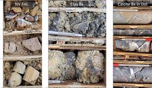
- Photo 1 shows the variety of breccia textures at G1, which overprint all lithologic units.
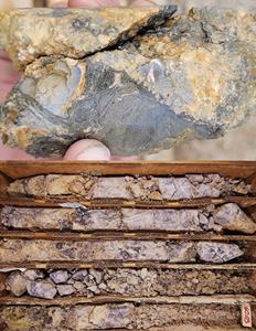
- The drill hole contains 2.4m @ 30.7 g/t silver, including 0.61 m @ 97.9 g/t silver.
- Photo 2 shows the breccia recovered in the core rubble through the silver-bearing interval.
- The hole was terminated in breccia, with 0.61 m @ 11.75 g/t silver at the bottom.
- Figure 2 shows the strong correlation of silver to the high temperature base metal signature of copper-moly-tungsten at G1, and also the correlation to the sulfide alteration signature of arsenic-antimony.
- Figure 2 also shows the introduction of hydrothermal gold into the G1 breccia over a length of 42 m; it correlates with, but overprints and extends beyond the polymetallic interval with silver.
- Introduction of hydrothermal gold is also evident over a 90m interval in the RC hole RV20-006, with a maximum of 176 ppb gold over 5ft, and above detection limit in nearly the entire hole.
- Hole 006 targeted the roots of the G1 breccia body approximately 130 m to the west of diamond drill hole RVD21-001 located on the ridge.
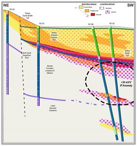
- Figure 3 shows the stratigraphic and structural control of brecciation and mineralization at G1.
- Figure 4 shows the breadth of the gold anomaly at Kawich. Hydrothermal gold is introduced over approximately 40 m of core in RC drill hole RV20-007, from 167 to 301 m, with up to 28 ppb Au. It is associated with secondary pyrite alteration hosted in dark grey, decalcified lime mudstone. Gold also occurs in the basal part of overlying Tertiary volcanic cover, which served as a fluid cap to the fluid system and is thus pervasively altered.
Figure 5 shows the high temperature vector in geochemical data, for example, molybdenum, which increases from the western flank of the range towards the Kawich anomaly in the covered valley. The same vector is evident in alteration mineral data obtained from the continuous hyperspectral scanning of each drill hole, in its entirety. For example, Figure 6 shows the vector of increasing high temperature potassium clay minerals from the western flank of the range towards Kawich.
Kawich was not explored during the previous 140 year history of prospecting in the district, yet this drilling confirms its potential as a porphyry center and overall driver of the polymetallic mineral system at Reveille.
Technical Information
Summary technical and geological information for the Company’s various exploration properties is available at the Company’s website at www.vrr.ca.
VR submits all surface grab samples and/or drill samples collected from Nevada-based exploration projects for geochemical analysis to the ALS Global (“ALS”) laboratory in Reno, Nevada. Sample preparation is completed in Reno. Analytical work includes ICP-MS analyses for base metals and trace elements completed at the ALS laboratories located in Vancouver, BC., and gold determination by fire assay atomic absorption spectrometry completed at facilities in Reno, Nevada. Analytical results are subject to industry-standard and NI 43-101
compliant QAQC sample procedures at the laboratory, as described by ALS, and with standard, duplicate and blank samples inserted internally by VR.
Technical information for this news release has been prepared in accordance with the Canadian regulatory requirements set out in National Instrument 43-101. Justin Daley, P.Geo., Exploration Manager & Chief Geologist at VR and a non-independent Qualified Person oversees and/or participates in all aspects of the Company’s mineral exploration projects and has reviewed the content of this news release. The Company’s CEO, Dr. Michael Gunning, P.Geo., is also a non-independent Qualified Person.
About the Reveille Property
The Reveille property is located approximately 90 km east of Tonopah, Nevada. Access is via Highway 6, with local roads and trails in and around the property itself.
The Reveille property now consists of 128 mineral claims in one contiguous block covering 2,619 acres (1,059 hectares) over an area of approximately 2 x 5.5 km. The property is on federal land administered by the BLM, and is outside of the BLM’s broadly defined area of sage grouse protection. There are no underlying annual lease payments on the property, nor are there any joint venture or carried interests on the property. There is an industry-standard royalty attached to the property, with a standard buy-back provision to VR.
About VR Resources
VR is an established junior exploration company focused on greenfields opportunities in copper and precious metals (TSX.V: VRR; Frankfurt: 5VR; OTCQB: VRRCF). VR is the continuance of 4 years of active exploration in Nevada by a Vancouver-based private company. The diverse experience and proven track record of its Board in early-stage exploration, discovery and M&A is the foundation of VR. The Company focuses on underexplored, large-footprint mineral systems in the western United States and Canada, and is well financed for its exploration strategies and corporate obligations. VR owns its properties outright, and evaluates new opportunities on an ongoing basis, whether by staking or acquisition.
The Company continues its normal course of business in 2021 within the framework of modified exploration programs in response to the COVID-19 pandemic, with the goal of ensuring the health and safety of staff and project personnel.
ON BEHALF OF THE BOARD OF DIRECTORS:
“Michael H. Gunning”
____________________________
Dr. Michael H. Gunning, PhD, PGeo
President & CEO
For general information please use the following:
| Website: | www.vrr.ca |
| Email: | info@vrr.ca |
| Phone: | 604-262-1104 |
Forward Looking Statements
This press release contains forward-looking statements. Forward-looking statements are typically identified by words such as: believe, expect, anticipate, intend, estimate, postulate and similar expressions or are those which, by their nature, refer to future events. Forward looking statements in this release include “In the meantime, we are already back on the ground completing reconnaissance work on the newly staked, buried conductor named “Big Apple” on the east side of the range …”, “follow-up work in 2022 will continue to evaluate targets in this area as the potential central driver and proximal source of the overall polymetallic mineral system at Reveille…”, and “VR evaluates new opportunities on an ongoing basis, whether by staking or acquisition.”
This news release contains statements and/or information with respect to mineral properties and/or deposits which are adjacent to and/or potentially similar to the Company’s mineral properties, but which the Company has no interest in nor rights to explore. Readers are cautioned that mineral deposits on adjacent or similar properties are not necessarily indicative of mineral deposits on the Company’s properties.
Although the Company believes that the use of such statements is reasonable, there can be no assurance that such statements will prove to be accurate, and actual results and future events could differ materially from those anticipated in such statements. The Company cautions investors that any forward-looking statements by the Company are not guarantees of future performance, and that actual results may differ materially from those in forward-looking statements. Trading in the securities of the Company should be considered highly speculative. Readers should review all of the Company’s public disclosure filings available at www.sedar.com.
Neither the TSX Venture Exchange nor its Regulation Services Provider (as that term is defined in Policies of the
TSX Venture Exchange) accepts responsibility for the adequacy or accuracy of this release
Graphics accompanying this announcement are available at
https://www.globenewswire.com/NewsRoom/AttachmentNg/49a98fac-369b-4b37-8982-00a1b5e5f55c
https://www.globenewswire.com/NewsRoom/AttachmentNg/0cb1372e-0e47-4ac9-9963-b4bab86dbd82
https://www.globenewswire.com/NewsRoom/AttachmentNg/b17783ac-4ba7-4fa3-8f55-c7880a3aba2d
https://www.globenewswire.com/NewsRoom/AttachmentNg/98c51a53-4e7c-4e39-b4a4-09ecd1030d5c
https://www.globenewswire.com/NewsRoom/AttachmentNg/af3612ae-4582-46ae-823f-569ff3431529
https://www.globenewswire.com/NewsRoom/AttachmentNg/6ee708eb-60ed-417f-b562-41eade6a7c09
https://www.globenewswire.com/NewsRoom/AttachmentNg/aa7ac9b2-1ba1-4ecc-b6f4-6ac8ce0ae104
https://www.globenewswire.com/NewsRoom/AttachmentNg/b4ced557-7565-40b0-809b-6c95528c8f9d


