Westward Gold Defines New Carlin-Type Gold Targets at Toiyabe Hills
(TheNewswire)
 | |||||||||
 |  |  |  |  | |||||
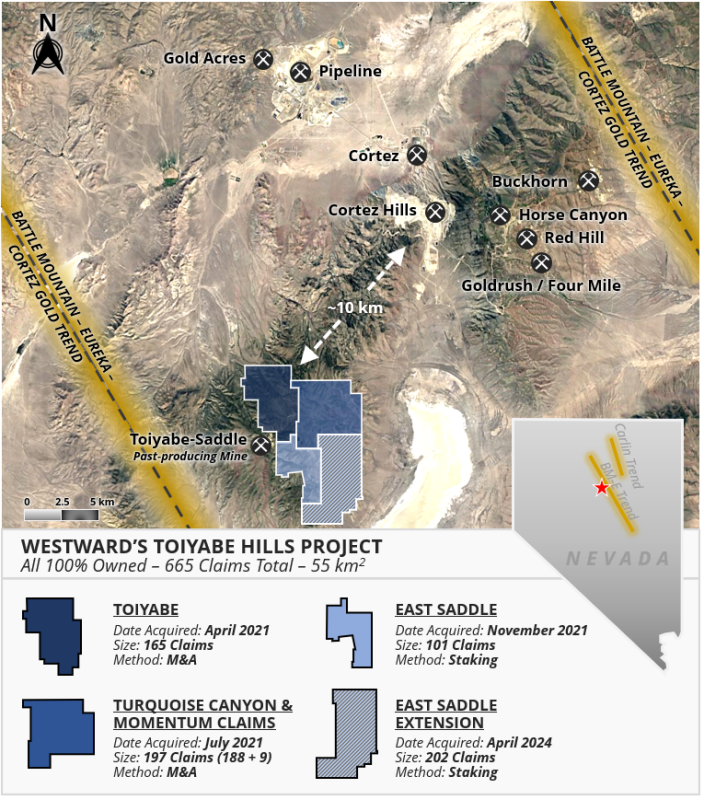
Vancouver, British Columbia, November 13, 2024 – TheNewswire – Westward Gold Inc. (CSE: WG, OTCQB: WGLIF, FSE: IM50) (“Westward” or the “Company”) is pleased to provide an update on its 2024 systematic field programs, which included 18 square kilometres of Anaconda-style geological mapping, the collection of 264 surface rock samples, a property-wide gravity survey at 200-metre station spacings, and a reinterpretation of legacy ZTEM data (Z-Tipper Axis Electromagnetic) at its flagship Toiyabe Hills Project (“Toiyabe Hills”, or the “Project”), situated along the Cortez Trend in Lander County, Nevada (see Figure 1 below). Multiple new high-priority zones are emerging at the Project; the Company is targeting favourable lower-plate carbonate rocks preserved under upper-plate cover rocks at reasonable drilling depths, notably within the Wenban, Horse Canyon and Roberts Mountains Formations – key hosts at all the multi-million-ounce gold deposits in the district. In addition to providing summary interpretations from this year’s exploration activities, this press release will focus on introducing one of Westward’s most prospective untested drill targets: the Campfire Target.
Westward Strategic Advisor Kelly Cluer commented: “Patient, persistent and multi-disciplinary systematic exploration programs on the big Nevada gold trends always bear fruit. We never set out to find more small gold deposits. Our vision is to identify gold systems and settings that will support company-making discoveries. I am thrilled that our laser-focused groundwork at Toiyabe Hills has exceeded expectations, and I am proud of this small but dynamic team for getting the foundational work done, and pulling this story together. The overall architecture and scale of the newly-recognized Campfire Target – including geologic framework, geophysical setting and geochemical footprint – are very similar to the environment around several of Nevada’s largest gold mines. Previously-identified near-surface gold mineralization at both Toiyabe Hills and the past-producing Toiyabe-Saddle Mine is now interpreted as a portion of the geochemical plume, with the Campfire Target zone potentially representing the ultimate feeder source for much of the known gold endowment. Situated near the intersection of old property boundaries, fragmented control of the district allowed it to slip through the cracks until Westward executed its unrelenting land consolidation. Now the proof of concept will be in the drilling.”
The 2024 Toiyabe Hills field program was designed to achieve the following goals: 1) expand the 1:5000 Anaconda-style geological mapping to improve Westward’s understanding of the Carlin-type hydrothermal alteration footprint and the structural architecture of the district; 2) increase the density of surface rock samples in emerging target areas and initiate coverage in previously-unsampled portions of the Project; 3) re-evaluate a 2011 ZTEM survey and integrate new interpretations with a property-wide gravity survey (refer to Westward’s press release dated September 26, 2024, for additional information); and 4) identify new drill targets within the Toiyabe Hills District. These goals were successfully accomplished and have resulted in the identification of several new and emerging high-value targets. Key highlights and interpretations are summarized below.
Figure 1: Westward’s Toiyabe Hills Project
Anaconda-Style Geological Mapping
-
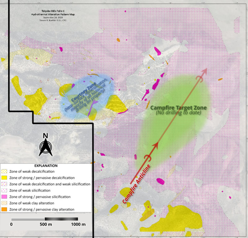
Carlin-type hydrothermal alteration was observed in lower-plate and upper-plate rocks over 11 of the 18 square kilometres mapped in 2024. Alteration remains open in multiple directions. Please click the following link to view the recently-completed geological interpretation and hydrothermal alteration pattern maps in full: https://westwardgold.com/projects/nevada-properties/geological-maps/
-
Confirmation of the Horse Canyon and Wenban Formations exposed at surface and generally dipping to the northeast – these favorable lower-plate strata host the nearby Pipeline and Cortez Hills deposits.
-
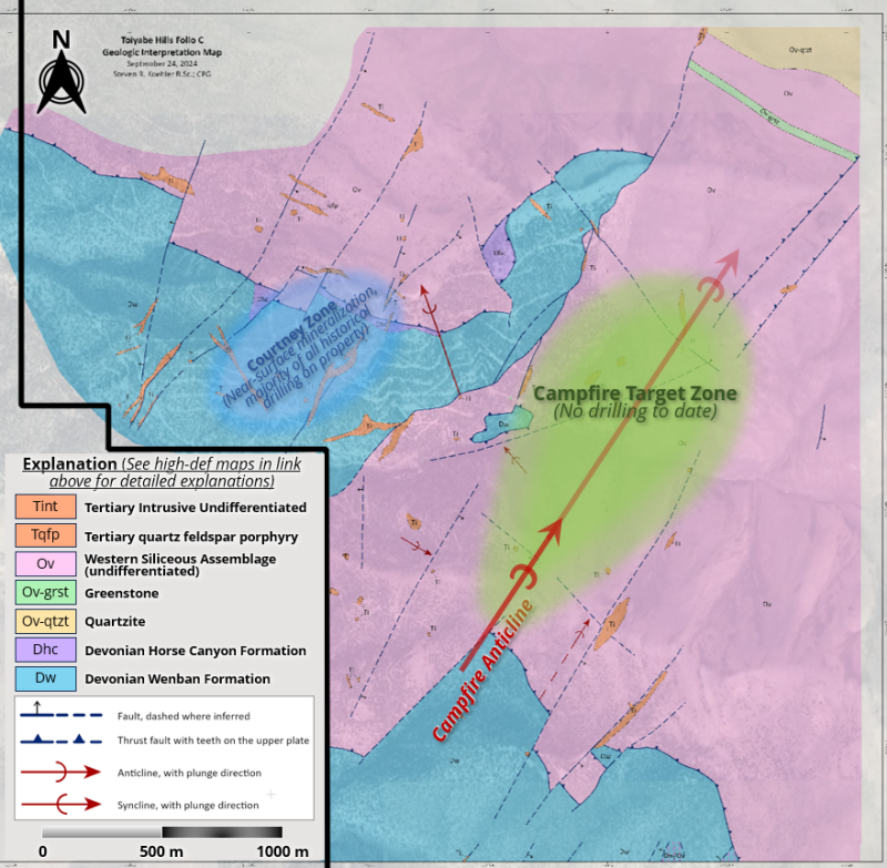
Identification of a 6-kilometre-wide corridor of igneous dike-filled, northeast-striking faults. Dikes range in composition from felsic to mafic and include quartz feldspar porphyry, diorite, and lamprophyre. Dike-filled fault corridors at Cortez and Carlin are well-documented features that are intimately associated with gold mineralization (see Figure 2 below).
-
Identification of two and perhaps as many as three district-scale compressional events, which produced thrust faults, imbricate zones, and folds – notably anticlines – in both upper and lower-plate rocks. Where exposed at surface, the northeast-plunging Campfire Anticline is host to punky decalcified lower-plate carbonate rocks that are cut by northeast-striking igneous dikes (see Figure 2 below). Anticlines developed in lower-plate carbonate rocks are key, well-documented gold controls in Carlin-type deposits.
-
Mapping continues to demonstrate that geological, structural, and hydrothermal alteration patterns of the Toiyabe District are consistent with, and reminiscent of, documented patterns associated with gold deposits in the Cortez and Carlin Districts.
Figure 2: Interpretive Geology – Mapping Folio C (Area Covering Campfire Target)
Figure 3: Hydrothermal Alteration Pattern – Mapping Folio C (Area Covering Campfire Target)
Rock Geochemistry
-
The 2024 rock samples ranged from <0.005 to 0.685 ppb gold (Au), 2 to 5754 ppm arsenic (As), and <0.1 to 434 ppm antimony (Sb).
-
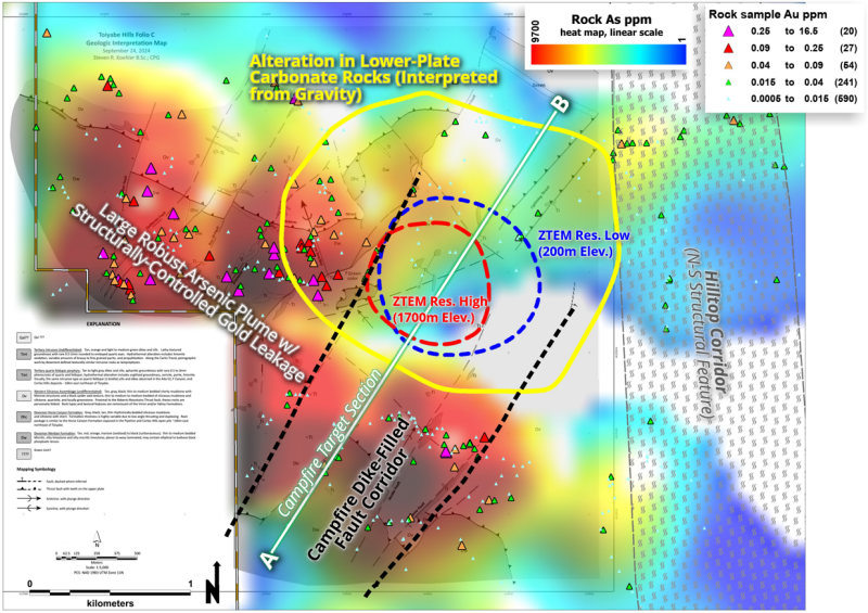
Geochemical heat maps (see Figure 6 below) generated from the complete property-wide rock geochemical database of 932 rock samples confirms an extensive Carlin-type geochemical footprint originally identified by gridded soil geochemistry.
ZTEM Survey Reinterpretation, 2024 Gravity Survey, and Combined Datasets
Based on the 2024 gravity survey interpretations (refer to Westward’s press release dated September 26, 2024, for additional information), the Company launched a re-examination of a legacy 2011 ZTEM survey. This information, examined now with the benefit of integration with other datasets unavailable at the time, led to five key takeaways, including:
-
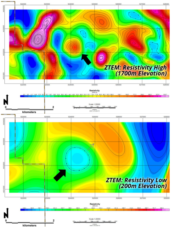
A pronounced circular resistivity high at approximately 1,700m elevation (see Figure 4 below).
-
A circular resistivity low at approximately 200m elevation (see Figure 4 below).
-
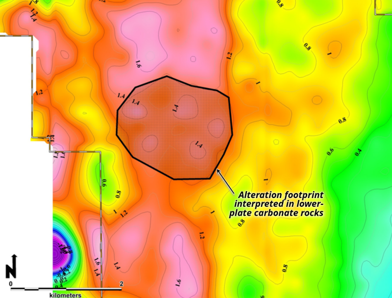
The circular resistivity high and resistivity low are within a 2km-diameter circular gravity feature interpreted as a zone of hydrothermal alteration and structural disruption in favorable lower-plate carbonate rocks (see Figure 5 below).
-
The resistivity and gravity anomalies are along the down-plunge projection of the igneous dike-filled Campfire Anticline (see Figure 6 below).
-
A distinct gold-arsenic geochemical plume is developed along the west and south margins of the circular geophysical features (see Figure 6 below).
Figure 4: Legacy ZTEM Data Highlighting Circular Feature
Figure 5: Residual Gravity (2024 Survey)
Figure 6: Combining Surface Mapping, Geochemical & Geophysical Datasets
The Campfire Target
The new Campfire Target was historically at the boundary of three independently-controlled claim blocks and essentially untestable. Westward’s persistence with district-scale land consolidation makes the Campfire Target a readily-accessible, high-value opportunity and the supporting technical details are compelling:
-
A large-scale target is indicated by the dimensions of alteration imaged at depth combined with the geochemical footprint associated with high-level Carlin-type alteration. The target area is approximately 1.5 km wide by 3.0 km long.
-
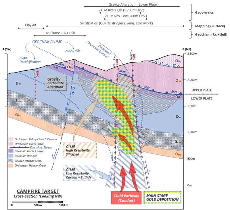
The Campfire Anticline is a northeast-plunging, dike-filled fold that is developed in lower-plate carbonate rocks. The down-plunge projection of the fold leads directly to the nexus of gravity (refer to Westward’s press release dated September 26, 2024, for additional information) and ZTEM-imaged alteration features (Figures 4 and 6 above). These patterns are typical of Carlin-type gold system feeder zones.
-
The Carlin-type geochemical plume mapped by extensive soil grid and rock sample surveys indicates a robust arsenic anomaly with gold and antimony, immediately up-plunge (to the west and south) from the gravity and ZTEM geophysical features, as expected for a main-stage fluid conduit in Carlin-type gold systems. Near-surface gold mineralization at the Courtney Zone, and in other adjacent mineralized zones, is interpreted as a portion of the geochemical plume. This structural, geochemical and geophysical nexus may represent the ultimate source for most of the known gold endowment at Toiyabe Hills.
-
Lower-plate carbonate target depths range from as little as 150m, in the southwest where the Campfire anticline crops out at surface, to 1.5km, in the northeast portion of the target area.
Figure 7: Campfire Target Cross-Section (AB) – Southwest to Northeast, Northwest-Viewing Schematic Section
Sampling Methodology, Chain of Custody, Quality Control and Quality Assurance (“QA/QC”)
All surface rock sampling was conducted under the supervision of the Company’s Vice President of Exploration or Technical Advisors. The chain of custody from the project to the sample preparation facility was continuously monitored. Certified reference materials or blanks were inserted approximately every thirty samples. The samples were delivered to Bureau Veritas Mineral Laboratories USA preparation facility in Sparks, NV where they were crushed and pulverized. Pulps were digested and analyzed for gold using fire assay fusion (FA430) and an atomic absorption spectroscopy (AAS) finish on a 30-gram split. All other elements were determined by ICP analysis (AQ200). Data verification of the analytical results included a statistical analysis of the standards and blanks that must pass certain parameters for acceptance to insure accurate and verifiable results. Bureau Veritas Mineral Laboratories USA is independent of Westward.
Qualified Person
The technical information contained in this news release was reviewed and approved by Robert Edie, Vice President Exploration of the Company, who is a Qualified Person under National Instrument 43-101 – Standards of Disclosure for Mineral Projects. Mr. Edie is a Certified Professional Geologist (CPG) through the American Institute of Professional Geologists (AIPG).
About Westward Gold
Westward Gold is a mineral exploration company focused on developing the Toiyabe Hills Project located in the Cortez Hills area of Lander County, Nevada, and the Coyote and Rossi Projects located along the Carlin Trend in Elko County, Nevada. From time to time, the Company may also evaluate the acquisition of other mineral exploration assets and opportunities.
For further information contact:
Andrew Nelson
Chief Financial Officer
Westward Gold Inc.
+1 (604) 828-7027
andrew@westwardgold.com
www.westwardgold.com
The Canadian Securities Exchange has neither approved nor disapproved the contents of this news release. The Canadian Securities Exchange does not accept responsibility for the adequacy or accuracy of this news release.
This news release contains or incorporates by reference “forward-looking statements” and “forward-looking information” as defined under applicable Canadian securities legislation. All statements, other than statements of historical fact, which address events, results, outcomes, or developments that the Company expects to occur are, or may be deemed, to be, forward-looking statements. Forward-looking statements are generally, but not always, identified by the use of forward-looking terminology such as "expect", "believe", "anticipate", "intend", "estimate”, “potential”, “on track”, “forecast", "budget", “target”, “outlook”, “continue”, “plan” or variations of such words and phrases and similar expressions or statements that certain actions, events or results “may”, “could”, “would”, “might” or “will” be taken, occur or be achieved or the negative connotation of such terms.
Such statements include, but may not be limited to, information as to strategy, plans or future financial or operating performance, such as the Company’s expansion plans, project timelines, expected drilling targets, and other statements that express management’s expectations or estimates of future plans and performance.
Forward-looking statements or information are subject to a variety of known and unknown risks, uncertainties and other factors that could cause actual events or results to differ from those reflected in the forward-looking statements or information, including, without limitation, the need for additional capital by the Company through financings, and the risk that such funds may not be raised; the speculative nature of exploration and the stages of the Company’s properties; the effect of changes in commodity prices; regulatory risks that development of the Company’s material properties will not be acceptable for social, environmental or other reasons, availability of equipment (including drills) and personnel to carry out work programs, that each stage of work will be completed within expected time frames, that current geological models and interpretations prove correct, the results of ongoing work programs may lead to a change of exploration priorities, and the efforts and abilities of the senior management team. This list is not exhaustive of the factors that may affect any of the Company’s forward-looking statements or information. These and other factors may cause the Company to change its exploration and work programs, not proceed with work programs, or change the timing or order of planned work programs. Additional risk factors and details with respect to risk factors that may affect the Company’s ability to achieve the expectations set forth in the forward-looking statements contained in this news release are set out in the Company’s latest management discussion and analysis under “Risks and Uncertainties”, which is available under the Company’s SEDAR+ profile at www.sedarplus.ca. Although the Company has attempted to identify important factors that could cause actual results to differ materially, there may be other factors that cause results not to be as anticipated, estimated, described or intended. Accordingly, readers should not place undue reliance on forward-looking statements or information. The Company’s forward-looking statements and information are based on the assumptions, beliefs, expectations, and opinions of management as of the date of this press release, and other than as required by applicable securities laws, the Company does not assume any obligation to update forward-looking statements and information if circumstances or management’s assumptions, beliefs, expectations or opinions should change, or changes in any other events affecting such statements or information.
Copyright (c) 2024 TheNewswire - All rights reserved.
