Westward Gold Releases Results from Inaugural Drill Campaign at Toiyabe; Step-Out Drilling Expands Mineralization from Historical Resource by 250 Meters
(TheNewswire)
 | |||||||||
 |  |  |  |  | |||||
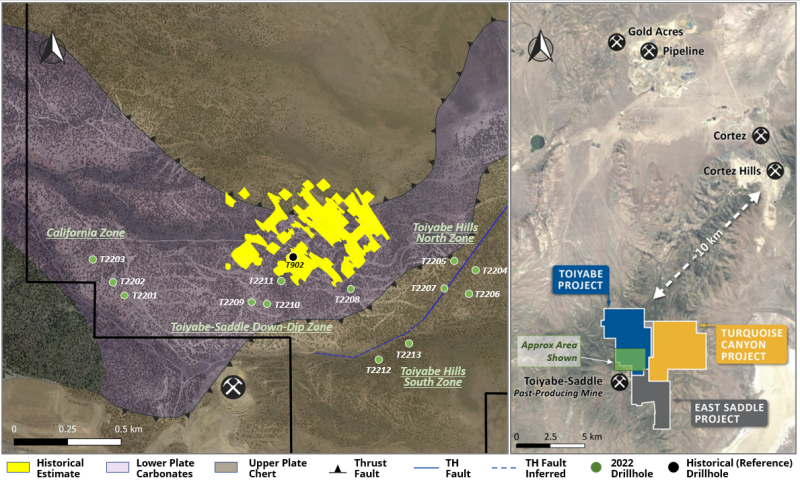
Vancouver, British Columbia – TheNewswire - October 18, 2022 – Westward Gold Inc. (CSE:WG), (OTC:WGLIF), (FSE:IM50) (“Westward” or the “Company”) is pleased to announce results from the Company’s inaugural drilling campaign at its flagship Toiyabe Project in Lander County, Nevada (“Toiyabe”). In total, the Company completed ~3,850 meters of reverse-circulation (“RC”) drilling across 13 vertical holes and 3 main target zones, all of which were outside of the footprint of the historical resource estimate at Toiyabe (~173 koz at 1.2 g Au/t)(1) (the “Historical Estimate”). See Figure 1 below for collar locations of all the drillholes completed in Westward’s 2022 campaign.
Key Highlights
Hole T2210 – a 250-meter southwesterly step-out from legacy drillhole(2) T902 (42.7 meters of 1.37 g Au/t) – intersected a vertically-continuous mineralized zone consisting of 50.3 meters of 0.34 g Au/t (including 3.1 meters of 1.57 g Au/t), confirming the discovery of an important gold-bearing structural horizon at Toiyabe.
-
With T2210, seven drillholes now define a zone of gold mineralization that is ~150 meters by ~410 meters laterally, and up to ~50 meters thick (the “SSD Zone”)
-
Mineralization is hosted within a favorable stratigraphic sequence known as the Wenban Formation – a key gold host at the nearby Pipeline and Cortez Hills deposits – and is associated with a blind thrust fault, a duplex zone, and an igneous dike / sill corridor
-
Westward believes the SSD Zone represents a new, emerging gold discovery that is open for expansion in multiple directions, with minimal drilling to-date
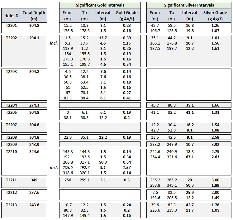
Additional Highlights (See Figure 2 for Results Table)
-
8 of the 13 drillholes (62%) encountered significant gold (defined as 1.5+ meters / 5+ feet of 0.14+ g Au/t), with 4 of those 8 having reportable intervals of 12.2+ meters (40+ feet)
-
At the California Target (~850-meter westerly step-out from Historical Estimate), drillhole T2202 intersected 13.7 meters of 0.59 g Au/t (including 4.6 meters of 1.15 g Au/t); shallow, near-surface gold mineralization is open in multiple directions
-
11 of the 13 drillholes (85%) encountered significant silver (defined as 9.1+ meters / 20+ feet of 1.0+ g Ag/t), with 6 of those 11 having reportable intervals of 25.9+ meters (85+ feet)
-
Widespread presence of silver indicates potential system extent and hydrothermal activity
-
Gold mineralization typically encountered within a broader “halo” of silver
-
-
For a video discussion of the results with CEO Colin Moore, VP Exploration Dave Browning, and Technical Advisor Steven Koehler, please see the following link: https://www.youtube.com/watch?v=MpRDcz0tHsE
Dave Browning, Westward’s Vice-President Exploration, noted: “Our drill location selection for this campaign was ambitious and included significant step-outs, testing blind targets. Confirmation and expansion of the SSD Zone represents a measurable improvement of our understanding of mineralization at the property, and opens up an abundance of near-term follow-up targets. The vast majority of legacy drilling was shallow, and this thick zone of mineralized material was only encountered in six previous holes.”
Steven Koehler, Technical Advisor to the Company, added: “Significant Carlin-type gold discoveries that I’ve been involved with – including Leeville, Pete Bajo, Turf, and Rita K – have often been preceded by the drilling of thick, lower-grade gold zones. This “smoke”, exemplified by T2210, is a common characteristic of larger gold systems. Westward has taken a systematic approach to early-stage exploration, and as the database of geological knowledge continues to grow, so does the potential to vector into a meaningful deposit.”
Figure 1: 2022 Drill Campaign at Toiyabe – Hole Locations
Figure 2: Significant Gold & Silver Intervals

Note: Gold intervals reported in Figure 2 were calculated using a 0.14 g Au/t cut-off; silver intervals reported were calculated using a 1.00 g Ag/t cut-off. Weighted averaging was used to calculate all reported intervals. True widths are estimated at 70-90% of drilled thicknesses.
Toiyabe-Saddle Down-Dip Target (“TSD Target”)
Prior to the Company’s inaugural drill campaign, legacy data review identified 6 historical drillholes (5 core, 1 RC) which intersected a broad zone of gold mineralization and alteration ~250 meters beneath, and separate from, the Historical Estimate at Toiyabe. The Westward technical team recognized the unique geologic characteristics of this horizon, and began referring to it as the SSD Zone.
Hyperspectral analysis indicated the potential for a northeast-trending tabular zone of mineralization and clay alteration; this was a new revelation which ran counter to many historical cross-sectional interpretations of the property. The TSD Target was chosen (3 drillholes, T2209-T2211) to begin to fill in a 600-meter strike length – between the Historical Estimate and the past-producing Toiyabe-Saddle Mine to the southwest – with no prior drilling.
Legacy diamond drillholes which intersected +1.00 g Au/t material in the SSD Zone included:
-
T1002: 33.8 meters of 1.16 g Au/t from 292.4 meters
-
T1601: 25.9 meters of 1.01 g Au/t from 278.4 meters
-
T902: 42.7 meters of 1.37 g Au/t from 266.7 meters
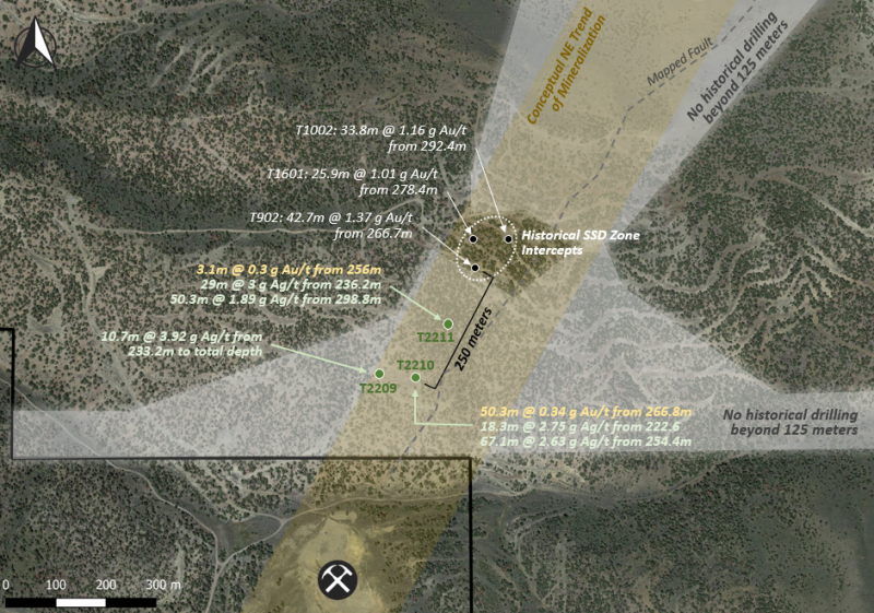
Figure 3: TSD Target Holes – Testing the SSD Zone
Gold mineralization observed in prior drilling typically occurs within larger structural zones of broken rock, gouge, oxidation, igneous sills and dikes, and two dominant structural fabrics at 30-50 and 70-80 degrees to the core axis. Structural features are consistent with a compressional environment; thrusts, ramps, and duplexes are present in both historical and 2022 drilling.
Observations from the three 2022 RC drillholes at the TSD Target include:
-
T2209: 10.7 meters of 3.92 g Ag/t from 233.2 meters to total depth (243.9 meters)
-
This hole was significantly shallower than both 2210 (324.6 meters) and 2211 (349.0 meters)
-
Presence of silver mineralization leading up to total depth indicates the hole ended before reaching the gold-bearing portion of the SSD Zone; in other holes, silver was observed both above and below gold intervals
-
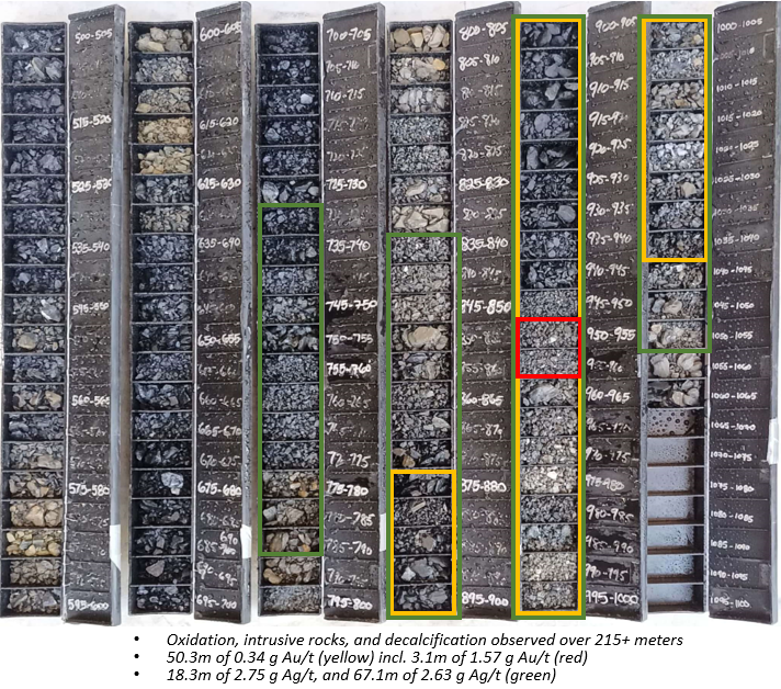
T2210: 50.3 meters of 0.34 g Au/t from 266.8 meters (including 3.1 meters of 1.57 g Au/t from 289.6 meters); 18.3 meters of 2.75 g Ag/t from 222.6 meters; 67.1 meters of 2.63 g Ag/t from 254.4 meters; see Figure 3 above and Figure 4 below
-
-
T2211: 3.1 meters of 0.3 g Au/t from 256 meters; 29 meters of 3.00 g Ag/t from 236.2 meters; 50.3 meters of 1.89 g Ag/t from 298.8 meters
Combining Westward’s datasets and knowledge to-date, the following observations may offer important guidance for follow-up campaigns:
-
The SSD Zone remains largely untested, with almost no drilling within a large corridor to the southwest and northeast of historical intervals (see Figure 3 above; grey shaded area represents areas with no prior drilling beyond 125 meters)
-
Areas beneath the Historical Estimate footprint have also seen no meaningful exploration
-
Mineralization is open to the northeast; the limited data to-date suggests gold grades strengthen in that direction along strike; more drilling is required to prove this out
Figure 4: Hole T2210 – RC Chip Trays

Note: Sample depths shown in Figure 4 above were recorded in 5-foot intervals.
California Target
Three drillholes (T2201-T2203) were completed with an average step-out distance of ~865 meters west of the reference hole within the Historical Estimate footprint. Both shallow and deep intervals of anomalous gold and silver were encountered in all three holes. The drillholes targeted strong gold- and arsenic-in-soil anomalies proximal to a northeast-striking dike swarm. T2202 intersected 13.7 meters of 0.59 g Au/t, including 4.6 meters of 1.15 g Au/t. Mineralization begins near the current topographic surface and is open in multiple directions.
Figure 5: Oxidation Observed in Hole T2202

Note: Sample depths shown in Figure 5 above were recorded in 5-foot intervals. Yellow: 13.7 meters of 0.59 g Au/t (including 4.6 meters of 1.15 g Au/t).
Toiyabe Hills Fault (“TH Fault”) Target
The TH Fault is a newly-identified structure, first discovered in late 2021 and later expanded upon through detailed field mapping conducted in 2022. It lies to the east and southeast of the Historical Estimate, striking northeast out of the past-producing Toiyabe-Saddle Mine and towards the Company’s Turquoise Canyon Project. Six holes were drilled along the fault trace, with four towards the northern end (T2204-T2208) and two at the southern end (T2212 and T2213); based on available data, the TH Fault had never been tested in any previous campaigns.
Three of the six holes intersected reportable gold, highlighted by T2205 with 12.2 meters of 0.40 g Au/t from 38.1 meters. Five of the six holes encountered significant silver with intervals of at least 18.2 meters (60 feet).
The TH Fault drillholes are characterized by thick zones of decalcification and brecciation in the Wenban Formation (up to 55 meters in multiple holes), abundant intrusive rocks, elevated silver and zinc, oxidation, and repetition of stratigraphy (duplexing); breccia zones are directly associated with elevated gold and silver. Strong decalcification was also observed within the duplex zones. These features indicate that the TH Fault is a hydrothermal and magmatic pathway, and additional drill targets remain along strike to the northeast of 2022 drilling.
Next Steps
The Company will undertake important follow-on analyses over the coming months, in preparation for the next stage of exploration targeting. Future campaigns will incorporate RC and diamond drillholes to test high-priority targets with near-term expansion potential, including the SSD Zone.
Data review is currently ongoing to further the Company’s knowledge of the new discovery:
-
Compilation and modeling of all significant silver intervals from legacy drilling (including a grade-thickness map) to better understand system extent; silver has a demonstrated ability to be a pathfinder to gold mineralization
-
Creation of multiple grade-thickness maps at various depth horizons to better understand the nature of stacked mineralization and target the blind SSD Zone
-
Correlation of multielement geochemistry to metal presence (2022 campaign is the first to test a full suite of elements)
-
Identification of priority historical drillholes to have composite pulps analyzed for multi-element geochemistry
-
Relogging of legacy RC holes across priority areas
-
Continued development of a tectonostratigraphic column
-
Hyperspectral imaging of 2022 RC chip trays
-
Continuation of 1:5000 detailed Anaconda-style geological mapping to the north and east of Historical Estimate, i.e., potential SSD Zone extent
-
Additional geophysics (fill-in gravity and CSAMT surveys) to identify SSD Zone expansion drill targets
Quality Assurance / Quality Control (“QA/QC”)
The Company implemented a best-practices QA/QC program during the 2022 drilling campaign. All sampling was conducted under the supervision of the Company’s Vice President Exploration or Project Geologist and the chain of custody from the project to the sample preparation facility was continuously monitored. Samples were transported directly from site to the ALS Ltd. (“ALS”) Sample Prep Facility in Elko, Nevada, and either prepped there or in Chihuahua, MX. Prepared sample pulps were then transported by ALS to their analytical laboratories in either Reno, Nevada, Vancouver, BC, or Lima, Peru.
RC samples were collected every five feet. Certified standards, rig duplicates, or blanks were inserted every 50 feet / 10 samples. All samples were analyzed for gold, silver, copper, and 46 additional elements. Assays consisted of fire assay / ICP (Au – ICP21) for gold, and four acid / ICP-MS (ME-MS61) for geochemistry.
Drill hole deviation for all 13 holes was measured by gyroscopic down-hole surveys with tooling provided by REFLEX of Elko, NV. The deviation surveys provided accurate data about the true inclination and azimuth of the holes. Obtaining an accurate survey of the drillholes leads to a better contextual understanding of the RC samples, and a more robust 3D geological model.
(1) Source: NI 43-101 Technical Report, American Consolidated Minerals Corporation, Prepared by Paul D. Noland, P. Geo., May 27, 2009 (the “2009 Technical Report”). A qualified person has not done sufficient work to classify the Historical Estimate at Toiyabe as current mineral resources and Westward is not treating the Historical Estimate on Toiyabe as a current mineral resource, as defined in National Instrument 43-101 – Standards of Disclosure for Mineral Projects (“NI 43-101”). The Historical Estimate was calculated using mining industry standard practices for estimating Mineral Resource and Mineral Reserves (2005) which was prior to the implementation of the current CIM standards for mineral resource estimation (as defined by the CIM Definition Standard on Mineral Resources and Ore Reserves dated May 10, 2014). The key assumptions, parameters and methods used to prepare the Historical Estimate on Toiyabe are described in the 2009 Technical Report. While Westward considers the Historical Estimate on Toiyabe disclosed in this news release to be relevant to investors, it cautions readers that it should not be unduly relied upon in drawing inferences on the mineralization on Toiyabe, as additional work is required to upgrade or verify the Historical Estimate as a current mineral resource. This additional work includes (but may not be limited to): re-sampling and re-assaying of available core and/or pulps, verification of assay certificates and digital assay data, verification of select drill hole collars, review and verification of drill hole geologic logs versus the preserved core and RC cuttings, incorporation of AuCN assays to provide a general understanding of metallurgical characteristics, review and verification of mineralization controls and modelling techniques.
(2) Sources: NI 43-101 Technical Report, IM Exploration Inc., Prepared by Donald E. Cameron, P.Geo., August 5, 2021; Toiyabe data room and drill log files inherited from previous operators. The Company and its qualified person have relied on third-party data during its review of the information presented herein, and while it believes the information to be relevant to investors, it cautions readers that it should not be unduly relied upon in drawing inferences on the mineralization at Toiyabe, as additional work is required to confirm drill intercepts and/or soil samples, including (but not limited to): re-sampling and re-assaying of available core and/or pulps, verification of assay certificates where available, review and verification of drillhole geologic logs versus the preserved core and RC cuttings.
Qualified Person
The technical information contained in this news release was reviewed and approved by Steven R. Koehler, Technical Advisor to the Company, who is a Qualified Person under National Instrument 43-101 – Standards of Disclosure for Mineral Projects. Mr. Koehler is a Certified Professional Geologist (CPG) through the American Institute of Professional Geologists (AIPG). The Qualified Person has verified the data disclosed in this news release.
About Westward Gold
Westward Gold is a mineral exploration company focused on developing the Toiyabe, Turquoise Canyon, and East Saddle Projects located in the Cortez Hills area of Lander County, Nevada. From time to time, the Company may also evaluate the acquisition of other mineral exploration assets and opportunities.
For further information contact:
Colin Moore
President, CEO & Director
Westward Gold Inc.
colin@westwardgold.com
www.westwardgold.com
The Canadian Securities Exchange has neither approved nor disapproved the contents of this news release. The Canadian Securities Exchange does not accept responsibility for the adequacy or accuracy of this news release.
This news release contains or incorporates by reference “forward-looking statements” and “forward-looking information” as defined under applicable Canadian securities legislation. All statements, other than statements of historical fact, which address events, results, outcomes, or developments that the Company expects to occur are, or may be deemed, to be, forward-looking statements. Forward-looking statements are generally, but not always, identified by the use of forward-looking terminology such as "expect", "believe", "anticipate", "intend", "estimate”, “potential”, “on track”, “forecast", "budget", “target”, “outlook”, “continue”, “plan” or variations of such words and phrases and similar expressions or statements that certain actions, events or results “may”, “could”, “would”, “might” or “will” be taken, occur or be achieved or the negative connotation of such terms.
Such statements include, but may not be limited to, information as to strategy, plans or future financial or operating performance, such as the Company’s expansion plans, project timelines, expected drilling targets, and other statements that express management’s expectations or estimates of future plans and performance.
Forward-looking statements or information are subject to a variety of known and unknown risks, uncertainties and other factors that could cause actual events or results to differ from those reflected in the forward-looking statements or information, including, without limitation, the need for additional capital by the Company through financings, and the risk that such funds may not be raised; the speculative nature of exploration and the stages of the Company’s properties; the effect of changes in commodity prices; regulatory risks that development of the Company’s material properties will not be acceptable for social, environmental or other reasons, availability of equipment (including drills) and personnel to carry out work programs, that each stage of work will be completed within expected time frames, that current geological models and interpretations prove correct, the results of ongoing work programs may lead to a change of exploration priorities, and the efforts and abilities of the senior management team. This list is not exhaustive of the factors that may affect any of the Company’s forward-looking statements or information. These and other factors may cause the Company to change its exploration and work programs, not proceed with work programs, or change the timing or order of planned work programs. Additional risk factors and details with respect to risk factors that may affect the Company’s ability to achieve the expectations set forth in the forward-looking statements contained in this news release are set out in the Company’s latest management discussion and analysis under “Risks and Uncertainties”, which is available under the Company’s SEDAR profile at www.sedar.com. Although the Company has attempted to identify important factors that could cause actual results to differ materially, there may be other factors that cause results not to be as anticipated, estimated, described or intended. Accordingly, readers should not place undue reliance on forward-looking statements or information. The Company’s forward-looking statements and information are based on the assumptions, beliefs, expectations, and opinions of management as of the date of this press release, and other than as required by applicable securities laws, the Company does not assume any obligation to update forward-looking statements and information if circumstances or management’s assumptions, beliefs, expectations or opinions should change, or changes in any other events affecting such statements or information.
Copyright (c) 2022 TheNewswire - All rights reserved.

