Northern Vancouver Island's mineral potential to be surveyed
Non-profit organization Geoscience BC is planning a new airborne survey to help identify mineral potential on northern Vancouver Island, in the western Canadian province of British Columbia.
According to the NGO, every time its team runs projects like this one, new investment comes into the region at hand as the data is used to inform mineral exploration and development decisions by the mining sector, government, communities, and Indigenous groups.
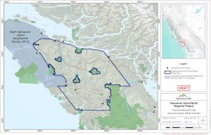
In a press release, Geoscience BC explained that the new airborne survey will use helicopters equipped with sensitive instruments that measure the properties of bedrock to help identify potential mineral deposits across Port McNeill and Sayward in the north and Zeballos, Tahsis and Gold River to the south of the island.


Map of the area to be surveyed.
A little bit of activity is already taking place in some of these areas with, for example, Troubadour Resources' (TSXV: TR) interest in developing the Surespan gold property, where the historic Zeballos high-grade gold mining camp lies.
But in the view of Geoscience's incoming Vice President for the Minerals division, Christa Pellett, more can be done. "We have heard from experts that even with its strong mining history, this part of northern Vancouver Island is likely to have understated mineral potential," Pellett said in the media brief.
Pellet also said that, before the survey starts, they would like to gather some information from locals to address any concerns and to make sure the data produced is the best, as it will be made public.
This is not the first time Geoscience BC goes up north on Vancouver Island. Back in 2013, the organization published the results from a survey carried out the year before and, according to its reports, just a couple of months after the data was released, over 16,000 hectares of new mineral exploration claims had been staked in the area.